Article

Seasonally Variant Stable Isotope Baseline Characterisation of Malawi’s Shire River Basin to Support Integrated Water Resources Management

1
Ministry of Irrigation and Water Development, Tikwere House, Private Bag 390, Lilongwe 3, Malawi
2
Department of Civil & Environmental Engineering, University of Strathclyde, Glasgow G1 1XJ, UK
3
Departments of Civil Engineering and Land Surveying, University of Malawi—The Polytechnic, Private Bag 303, Blantyre 3, Malawi
4
BASEflow, P.O. Box 30467, Blantyre, Malawi
*
Author to whom correspondence should be addressed.
Water 2020, 12(5), 1410; https://doi.org/10.3390/w12051410
Submission received: 28 February 2020 / Revised: 6 May 2020 / Accepted: 8 May 2020 / Published: 15 May 2020

Abstract

:
Integrated Water Resources Management (IWRM) is vital to the future of Malawi and motivates this study’s provision of the first stable isotope baseline characterization of the Shire River Basin (SRB). The SRB drains much of Southern Malawi and receives the sole outflow of Lake Malawi whose catchment extends over much of Central and Northern Malawi (and Tanzania and Mozambique). Stable isotope (283) and hydrochemical (150) samples were collected in 2017–2018 and analysed at Malawi’s recently commissioned National Isotopes Laboratory. Distinct surface water dry-season isotope enrichment and wet-season depletion are shown with minor retention of enriched signatures ascribed to Lake Malawi influences. Isotopic signatures corroborate that wet-season river flows mostly arise from local precipitation, with dry-season flows supported by increased groundwater contributions. Groundwater signatures follow a local meteoric water line of limited spread suggesting recharge by local precipitation predominantly during the peak months of the wet-season. Relatively few dry-season groundwater samples displayed evaporative enrichment, although isotopic seasonality was more pronounced in the lowlands compared to uplands ascribed to amplified climatic effects. These signatures serve as isotopic diagnostic tools that valuably informed a basin conceptual model build and, going forward, may inform key identified Malawian IWRM concerns. The isotopic baseline establishes a benchmark against which future influences from land use, climate change and water mixing often inherent to IWRM schemes may be forensically assessed. It thereby enables both source-water protection and achievement of Sustainable Development Goal 6.

Graphical Abstract

1. Introduction

A plethora of factors ranging from rapid human population growth, urbanization, change in life style to unreliable rainfall, increased agricultural demands, degradation of water resources and catchment areas, decline in groundwater quantity and quality, climate change, call for an integrated approach to the formulation of policies pertinent to Integrated Water Resources Management (IWRM) [1]. This poses a big challenge in developing countries. In Malawi and other countries across Africa, Sustainable Development Goal 6 is focused on the large populations who still lack access to safe water and sanitation services [2]. Integrated efficiency in the conjunctive management of water resources is required to balance competing societal demands and increasing water stress and allow development of cost-effective measures to sustainably manage water resources. Use of advanced technologies and tools to support such efforts is often limited in the developing countries.
Isotope hydrology has the potential to shed light on surface water and groundwater dynamics and interdependencies that underpin IWRM [3]. The value of isotope hydrology in IWRM is well known for enhancing understanding of the behaviour and interdependencies of groundwater and surface water and allowing more informed decision making by water managers and policy makers [4,5,6,7]. The potential of isotopes, often regarded as research tools, needs to be better realized and made more readily available to developing countries to support complex IWRM needs often amidst rapid resource development [8].
This is not to say isotope hydrology tools use has not been used across Africa, far from it. Their use though is often restricted to international research studies with sample analysis undertaken abroad, failing to develop in-house capacity. The range in application of isotope tools across Africa is impressive; covering, source provenance and climate controls [9,10,11] modern recharge [12,13,14], historic recharge and paleoclimate [15,16], flow regime and water [17,18,19], deep groundwater discharge to surface water [20], groundwater–surface-water interaction [16,21,22], seasonal influence [10,23], system stress (e.g., drought, flood and irrigation) [24,25,26] and contamination concerns (e.g., salinity) [27,28]. Such wide and increasing coverage of topic areas relevant to IWRM provides impetus to further widen developing-country access to isotope tools, especially access to in-house national (or locally shared international) laboratory facilities that facilitate isotope tool transition from one-off research studies to everyday management decision support.
Malawi has recently made strides in achieving this transition through the establishment of a national isotope hydrology facility and initiating stable-isotope baseline characterisation of key catchments [29]. Prior to this, use of isotope tools supporting IWRM was limited in Malawi with samples exported abroad [30,31,32,33,34,35,36,37]. The International Atomic Energy Agency (IAEA) has been promoting the use of isotope hydrology in IWRM in Malawi since 2012. With funding from IAEA and the Scottish Government supported Climate Justice Fund (CJF)—Water Futures Programme, Malawi has built technical capacity in both basic and advanced isotope techniques for its personnel in the Ministry of Irrigation and Water Development (MoIWD). The IAEA supported the MoIWD in establishing an Isotope Hydrology laboratory at the Central Water Laboratory (CWL) in Lilongwe with catchment baseline characterisation studies undertaken by CJF led by the University of Strathclyde. These initiatives support Government efforts in attaining Sustainable Development Goal (SDG) 6, which focuses on ensuring availability and sustainable management of water and sanitation for all people.
Our overarching goal for this research was to characterise the seasonally variant stable isotope—hydrochemical baseline of the Shire River Basin (SRB) catchment that drains from Lake Malawi into the Zambezi system in neighbouring Mozambique. Basin-wide isotopic characterisation has not been previously undertaken, although isotopic data have been obtained for some SRB sub-catchments [32,33,36]. The SRB covers much of the southern part of Malawi, and is the largest of several catchment studies initiated that include the Linthipe catchment draining to Lake Malawi to the north [29], the Phalombe catchment draining to Lake Chilwa, a follow-on SRB—Mozambique transboundary study and a Malawi-wide precipitation study.
Objectives identified to meet this goal were: to provide stable isotope–hydrochemical baseline characterisation of the SRB comprehensively covering precipitation, surface water and groundwater components thereby providing a reference for future isotope-based applications; to characterise the seasonal variation in isotope signatures and, to evaluate isotope signature informing of controlling processes relevant to IWRM. The study findings are important to the implementation of the recently announced successor project of the World Bank Funded Shire River Basin Management Programme (SRBMP) through improvement of information and data regarding surface-water and groundwater resource availability. The study is also significant in that it employs knowledge of isotopes to understanding of water resources in a transboundary catchment—both surface water and groundwater—flowing into the Zambezi system. It is envisaged that study findings arising from using isotopes in Malawi together with increased use in neighbouring countries will add value to the ‘Agreement on Establishment of the Zambezi Watercourse Commission’ (‘ZAMCOM’) signed in 2004 between the Republics of Angola, Botswana, Malawi, Mozambique, Namibia, Tanzania, Zambia and Zimbabwe, aimed at ensuring efficient management of shared watercourses. This is a crucial tool in avoiding conflict and enhancing integrated economic development in the region.

2. Materials and Methods

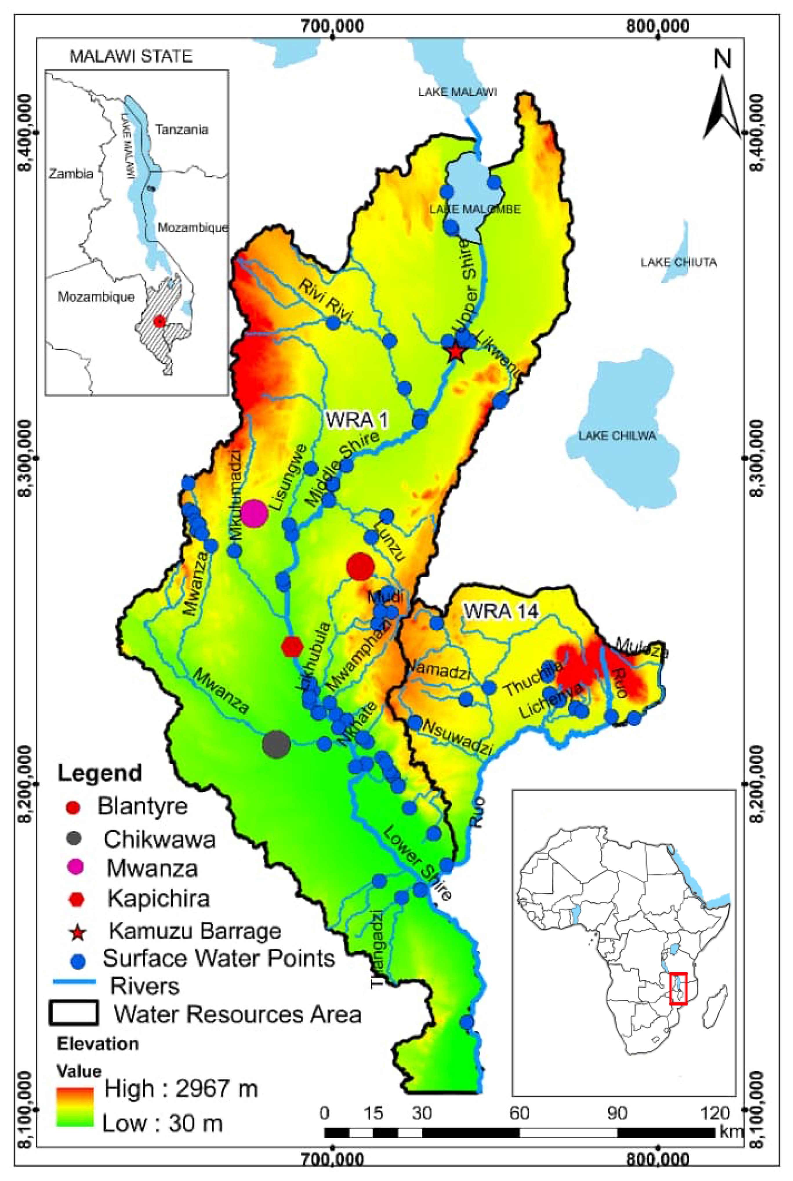
2.1. Study Area Setting

2.1.1. Water Resources

The Shire River Basin (SRB) lies between 9° and 20° S; and 18° and 36° E, at the southern extreme of the East African Rift System (EARS; noting a listing of all abbreviations used herein is provided in the Supporting Materials; Table S8). The SRB occupies an area of circa (c.) 28,800 km2, with the Malawian section of the Basin covering Water Resources Area (WRA) 1 and WRA 14 (Figure 1). It drains much of Southern Malawi and is divided into upper, middle and lower sections. The upper SRB, covering c. 4500 km2, extends from Lake Malawi’s outlet point to Liwonde Barrage. The middle section covers c. 4700 km2, extending downstream to Kapichira with Rivi-Rivi, Lisungwi and Wamkulumadzi as major tributary rivers. The lower SRB extends from Kapichira in Chikwawa district to Malaka in Nsanje district and covers 7200 km2 [38]. The Shire River forms the sole outlet of Lake Malawi, one of Africa’s largest lakes that extends over some 600 km of the Rift Valley covering an area of c. 26,500 km2. Lake Malawi’s catchment extends over much of Central and Northern Malawi that accounts for 68% of the total c. 97,740 km2 catchment area that extends into both Tanzania and Mozambique. The lake is of great economic significance and sustains the country’s hydro-power generation by boosting Shire River flow rates, especially important during the peak of dry season when river flow rates become low as inflows from major tributaries decline, often becoming dry.
The Shire flows through Southern Malawi into Mozambique to join the Zambezi River that drains into the Indian Ocean. River flows vary seasonally in the Lower SRB from c. 400–1000 m3/s and depending largely upon water levels in Lake Malawi, especially during the dry season [39]. The river has major riverine inflows including the Ruo River, a transboundary river that drains WRA14 from Mulanje Massif. Some of the basin urban centres are served by Shire River off-takes, the largest being the City of Blantyre, which abstracts close to 100 ML/d (mega-litres per day), pumped over a head of 800 m through a 48-km pipeline from the intake at Walker’s Ferry to the city [40]. A series of rapids—cascades on the middle Shire River allow generation of some 99% of Malawi’s hydropower [38].
Groundwater from mainly shallow alluvial or basement rock aquifers forms the principal water supply source for Malawi’s predominantly rural population. Rural village communities in the SRB are frequently served by hand-pumped boreholes or gravity-fed piped water supply schemes, with c. 18,380 boreholes and 10,296 piped taps mapped as of October 2019 [41]. Poor functionality though of many water points, with c. 30% typically non-functional, leads to water infrastructure ‘asset stranding’ and calls for larger capacity supply schemes [42,43]. The agricultural sector remains the major water user taking 749 ML/d (79% of demand) of the available water resources in the SRB, followed by domestic water supply at 14%, industrial sector at 4% leaving 3% unaccounted for [40]. The SRB is a pivotal developmental hub for Malawi’s economic growth [44], with several major commercial agricultural activities ranging from sugar, tea and cotton plantations to livestock production. A major initiative is the Government of Malawi’s $500 million (USD) World Bank and African Development Bank Funded Shire Valley Transformation Project (SVTP) launched in the Lower SRB, which will divert c. 5% (20–50 m3/s) of the Shire River flow into 130 km of feeder canals and drain network to provide gravity-fed irrigation of 45,000 hectares [45].
The Shire River (and Ruo tributary) is a transboundary surface-water body shared between Malawi and Mozambique. The Lower SRB alluvial aquifer is also a Trans-Boundary Aquifer (TBA) [46]. Malawi and Mozambique are members of the Zambezi Water Commission (ZAMCOM), a platform within the SADC region seeking to promote equitable allocation of shared water courses between its member countries/states. The aforementioned ZAMCOM agreement promotes safeguards for downstream users’ (Mozambique) interests relative to those of upstream users such as Malawi. Therefore, there is a critical need to promote and enhance sustainable management of the SRB to ensure conformity with both international and national environmental water laws and regulations.
The SRB faces a growing threat of environmental degradation stemming from developmental pressures such as rapid population growth (c. 3% per annum), urbanization, industrialisation and increasing waste among others from both countries of Malawi and Mozambique. The area is vulnerable to climate change with frequent flood and drought extreme occurrences [47]. This situation leaves both the quantity and quality of water resources to be at risk. There are cases of high saline groundwater from community boreholes that lead to abandonment of production boreholes and possible unsafe use of alternative unprotected and microbiologically contaminated water points to avoid salinity problems [45,48,49,50]. Localised occurrence of fluoride in groundwater is a concern [51]. Unquantified threats arise from increasingly intensive commercial agriculture (sugar, tea and coffee plantations) and associated agrochemicals use. Occurrence of microbiological pathogens remains a concern in unimproved surface-water sources and some groundwater sources such as shallow hand-dug wells vulnerable with related unquantified risks to groundwater posed by widespread increased adoption of pit latrine sanitation of basic design [52]. There is an alarming rate of deforestation that accelerates runoff, causing siltation of surface waters, quality deterioration and weed manifestation, alongside reduced groundwater recharge and decreased dry-season baseflows to rivers [53]. Such complexities highlight the need for IWRM to conserve available water resources for basin rural and urban sectors, meet environmental (ecosystem services) needs and transboundary obligations.

2.1.2. Geology and Hydrogeology

The SRB mainly comprises superficial (alluvial sediment) deposits and basement lithologies [54]. The main aquifer types are the weathered basement complex, the fractured basement complex and the unconsolidated quaternary superficial (or ‘alluvial’) deposits and the Karoo sedimentary and igneous sequences (Figure 2). The basement units form much of the upland areas and are dominated by gneiss and granulite, exhibiting fractures induced from the East African Rift System (EARS) and weathering in topographic highs from erosion. Although borehole yields from the basement are low, up to around 1 L/s, these are still sufficient for community hand-pumped supply. The basement aquifers extend over vast areas and are hence widely relied upon. Karoo Sedimentary rocks exist unconformably on the basement but only in the southwest higher elevations. Groundwater storage and flow occurs largely in fractures in these well cemented low porosity rocks that may provide local supplies. Unconsolidated sedimentary sequences of superficial aquifer deposits (alluvium and colluvium towards valley margins) generally have good permeability, porosity and storage. They are comprised of clays, silts, sands and occasionally gravels, deposited in the floor of the rift valley typically increasing in thickness eastwards (>100 m) towards their faulted contact with the basement. Even though finer grained deposits may predominate across the low-lying plains, alluvial aquifer yields are typically quite high and can on occasion exceed 10 L/s in suitably located boreholes in the more permeable sand—gravel deposits [54]. The topographical high areas receive higher rainfalls within the SRB around Mulanje and in the north of the Basin near Lake Malawi, providing the best recharge zones. Within the Shire River plain itself rainfall is more limited with recharge principally occurring around February to March when top soils become saturated [2,40]. However, estimations of recharge are not particularly well constrained as often is the case.

2.1.3. Topography and Climate

The SRB has diverse relief, dominated by the East African Rift System (EARS) valley and plains. Relief ranges from 30 Meters Above Sea Level (m a.s.l.) in the south to about 3000 m a.s.l. in the Mulanje massif. The area is characterised by highlands over 1300 m a.s.l. in the south west of Ntcheu District where Malawi borders Mozambique and in the Mulanje District where the highest highlands occur, but also lowlands below 200 m a.s.l. in Chikwawa and Nsanje districts within the Lower SRB comprising extensive, semi-arid valley plains across the basin.
A tropical climate occurs with two distinctive seasons—a wet season and a dry season, with both cool dry and hot dry periods. The wet season starts in November ending in April. The first part of the dry season, cool-dry, starts in May ending in August and the last part, hot-dry, commences in September ending in October. Based on the current Köppen-Geiger system global dataset of long-term monthly precipitation and temperature station time series, Malawi’s climate may be classified as Aw or Savannah. The defining criteria for this climate type is Not (Af) and Pdry < 100—MAP/25, where Af is rainforest, MAP is mean annual precipitation, and Pdry is precipitation of the driest month [55]. Rainfall in the SRB is largely influenced by Intertropical Convergence Zone (ITCZ), tropical cyclones and the Zaire Air Boundary. Mean monthly rainfalls across the SRB range from 6 to 290 mm with the mean of 98 between the period 1999 and 2019 (Figure S1a). Annual mean rainfall is distributed between 700 and 2500 mm in lowlands and highlands, respectively and peak rainfall occurs between December and March. Mean monthly temperatures range from 13.1 to 32.1 °C with the mean of 22.9 between the period 1999 and 2019 (Figure S1b). During the cool dry season, some highland areas experience erratic winter rains, locally known as Chiperone, due to inflow of cool moist south-eastern winds. Mean temperatures for the cool-dry season vary between 17 and 27 °C, with occasional temperature drops spanning from 4 to 10 °C. Wet season mean temperatures range from 25 to 37 °C [40,56].

2.1.4. Data Availability

Water-resources monitoring data such as precipitation and surface-water flow and level data are generally available, although records may not always be complete [57]. Groundwater level data are sparse (handpumps typically inhibit measurement access), but will improve with recent commissioning of 75 dedicated groundwater monitoring wells nationally. Surface-water and groundwater quality data (mostly major ions, field parameter, bacterial, fluoride, etc.) data exist to a moderate degree, enough to allow conceptualisation of occurrence and limited decision making [58]. Data are somewhat ad-hoc though with the establishment of routinely sampled monitoring networks problematic, but improving [43]. Collation of data into centralized accessible electronic databases also varies. The CJF programme has made significant contributions to the development of management information systems and mapping of all water points throughout Malawi on behalf of the government to underpin IWRM and support attainment of SDG (6) [42,59].

2.1.5. Water Sampling and Analysis

Surface-water and groundwater sampling aimed to provide representative coverage of the study area’s main features (Figure 1 and Figure 2). Surface-water sampling covered the main Shire River reaches and a cross section of representative tributaries. Groundwater sampling provided geographical spread and balanced hydrogeological coverage of the basement and superficial aquifer systems. Survey timings provided seasonal coverage and lowland and upland sampling points captured topographic influences. Coverage was constrained by ease of access, especially during the rainy season where travel to some remote or through low lying flood-prone areas was not possible. Occasional clumping of sample sites arose from intent to underpin higher resolution local studies expected to follow, for instance within the Chikwawa district.
Three sets of field surveys were conducted between March 2017 and April 2018 yielding a total of 433 samples (283 stable isotopes samples and 150 hydrochemical samples). Surface-water sources sampled included rivers, a lake and a dam. Groundwater sources included production boreholes fitted with (Afridev) hand pumps (for community supply) (92), a hot-spring (a recreational-bathing site), capped artesian wells (for community supply) (3) and a monitoring well (for groundwater monitoring). These groundwater sources were predominantly in daily use for supply and hence well purged. The initial survey was conducted during the cool-dry season between March and August 2017 when a total of 124 (68 stable isotopes and 56 hydrochemical) samples were collected. The second survey was during the hot-dry season between September and October 2017 and a total of 124 (72 stable isotopes and 52 hydrochemical) samples were collected. The final survey was during the wet season between November 2017 and April 2018 with a total of 185 (143 stable isotopes and 42 hydrochemical) samples collected. The stable isotopic data for precipitation throughout the study area were judged spatially and temporally insufficient and collected local data were augmented by surrounding country relevant data. The local meteoric conditions of the study area were therefore characterised using stable isotope data generated from monthly samples taken between 2014 and 2019 from the Malawi Network of Isotopes in Precipitation (MNIP) stations (Table S1) equipped with dip-in samplers that are designed to prevent evaporation (and eliminate the need for paraffin oil [60]. These local precipitation data were then augmented by precipitation isotopic data obtained from neighbouring international Global Network of Isotope in Precipitation (GNIP) stations in Mozambique at Gorongosa (8 monthly samples) and Chitengo (4 monthly samples) and Zambia at Ndola (154 monthly samples) to allow a more complete characterisation [61] (Table S2). These stations have a similar climate and comparable rain-bearing systems to that of the SRB. The resultant Local Meteoric Water Line (LMWL) derived from a subdataset of precipitation amounts weighted stable isotopic samples (n = 143) (from stations with precipitation amount data) was calculated by error-in-variables regression denoted EIV-LMWLw. The EIV-LMWLw equation was presented with uncertainties (standard errors which represents mean deviation of isotopic values from the EIV-LMWLw) for its slope and intercept (deuterium excess defined as δ2H = 8δ18O significantly linked to vapour source regions) [29,62]. The regression equation for the weighted EIV-LMWLw was then compared with an equation for a regressed entire non-weighted dataset (n = 206) to check any variations in extent of slope and intercept that were found to be immaterial (Supplementary Material: Regression analysis). The summary statistics of the precipitation isotopic data were based on the entire dataset, while the LMWL and isotope-related plots were based on the precipitation amounts weighted dataset only.
Hydrochemical samples were collected using a distilled water rinsed pair of acidified and non-acidified polyethylene bottles, stored at 4 °C during transportation and holding at MoAIWD laboratory and filtered through 0.45 µm pore size Whatman filters prior to laboratory analysis. Field parameters (Temperature, pH, Total Dissolved Solids (TDS) and Electrical Conductivity (EC)) were measured using a portable multimeter (Model: HI-98194, Hannah Instruments, Woonsocket, RI, USA). Standard titration method was used to determine carbonate as CO32−) and bicarbonate as HCO32− (standard hydrochloric acid method), magnesium as Mg2+ and calcium as Ca2+ (standard EDTA method) and chloride as Cl (standard silver nitrate method). A flame photometer (Model: 410, Camlab, Cambridge, UK) was used to measure sodium as Na+ and potassium as K+ based on flame photometry method, while an Ultra Violet (UV)/visible spectrophotometer (Model: DR/3000, Hach, Loveland, CO, USA) was used to measure nitrate as NO3, sulphate as SO42− and iron as Fe2+ based on calorimetric and spectrophotometry method. All field and laboratory activities (onsite measurements, sample collection, transportation, holding, preparation and analysis) were conducted in accordance with International Standard Methods (ISM) [63]. Standard blanks and duplicate samples were used to assure and control quality of the analysis process, and all instruments were properly calibrated following standard instructions prior to field and laboratory analyses, while accuracy of the analysis results was validated by calculation of ion-balance, with adherence to an acceptable error of ±5%.
Water stable-isotope samples from surface water and groundwater were collected in dedicated amber bottles for analysis of deuterium (δ2H) and oxygen-18 (δ18O) values using an automated cavity ring-down spectrometer called Picarro isotopic water analyser (Model: L2110-I, Picarro, Santa Clara, CA, USA) at MoIWD Isotope Hydrology Laboratory (IHL) based on laser spectroscopy method. Stable isotope samples from Lake Malombe, located in the upper SRB (Figure 1), were collected remote from estuaries c. 1 km from the shoreline via boat and bespoke depth sampler. The water isotope samples were kept at 4 °C, away from sunlight during transportation and holding at the IHL. The stable isotope analysis involved daily calibration of heavy and light standards bracketing probable isotopic content range of the water isotope samples, together with the use of a daily control mid-range standard intermediate between heavy and light standards. The Picarro isotopic water analyser was prepared by running two vials of deionised water and accuracy of measurement was checked by inspecting concentration peaks, with adherence to an acceptable range of 19,000–21,000 ppm for abundance of isotope ratios for both deuterium (δ2H) and oxygen-18 (δ18O). The isotopic analysis precision (2σ) was set at ±0.2‰ for oxygen-18 and ±2.0‰ for deuterium, while quantification and validation of results was accomplished via dedicated Laboratory Information Management System (LIMS) software. The processed isotopic analysis results were reported in delta values (δ) representing parts per thousand deviations (‰) from the international V-SMOW (Vienna Standard Mean Ocean Water) [64]. All field and laboratory activities (onsite measurements, sample collection, transportation, holding, preparation and analysis) were conducted in accordance with the IAEA-ISM [65].

3. Results

3.1. Stable Isotope Results

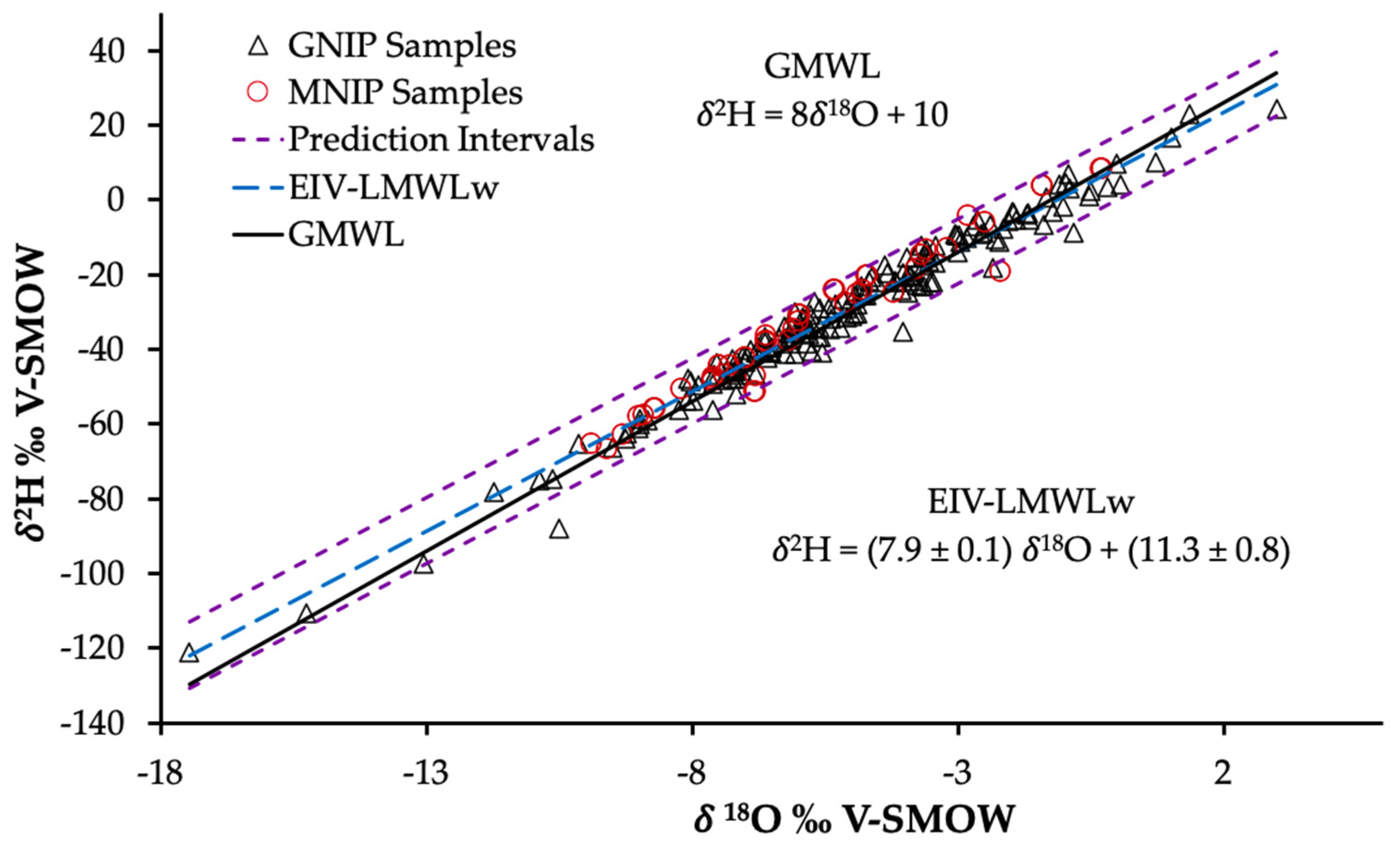
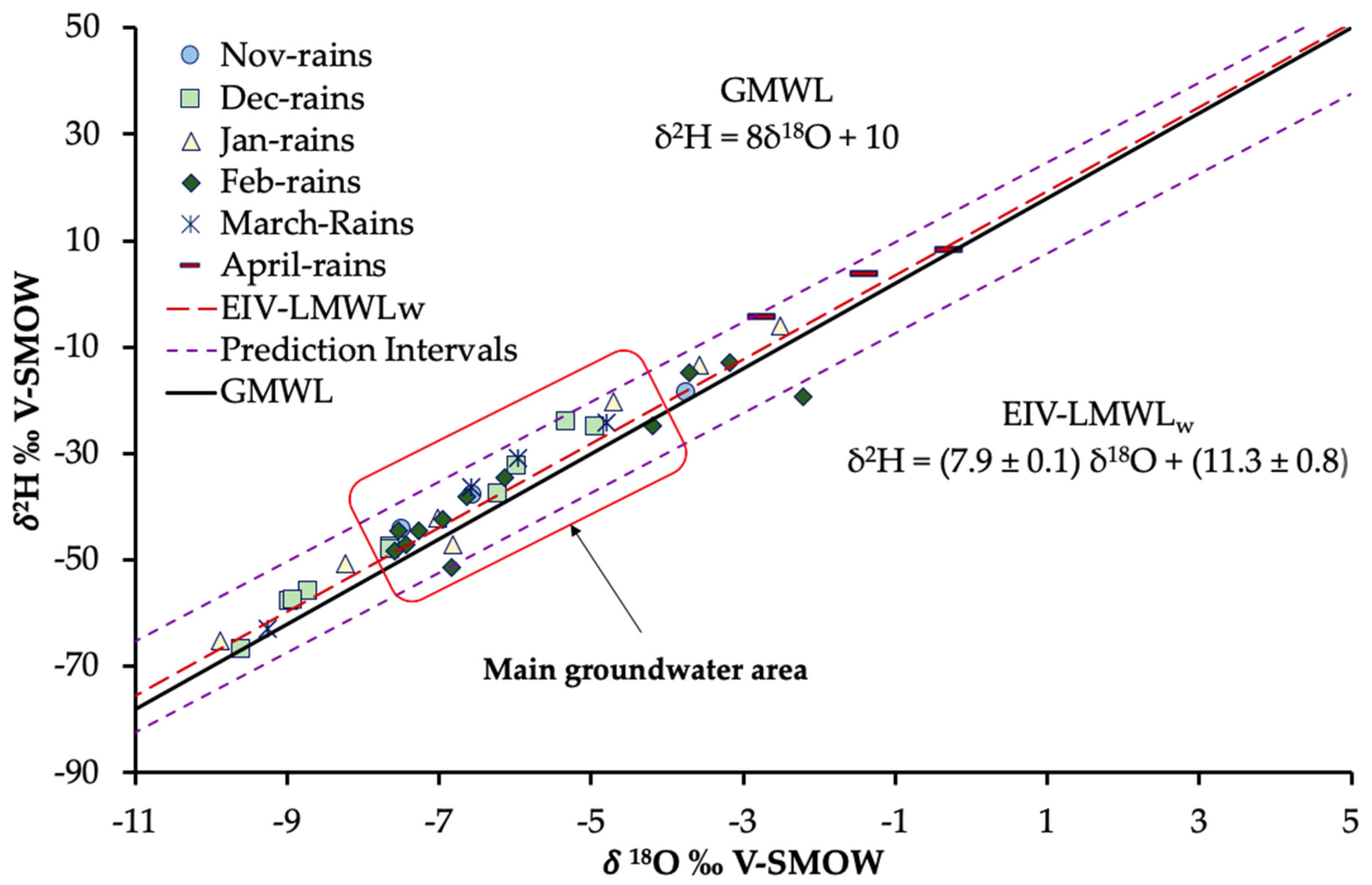
3.1.1. Isotopic Content of Precipitation-Local Meteoric Characteristics

Local meteoric conditions of the Shire River Basin were described by a Local Meteoric Water Line (LMWL) defined as δ2H = (7.9 ± 0.1)δ18O + (11.3 ± 0.8) (Figure 3; and was calculated by error-in-variables (EIV) regression, hence termed herein the EIV-LMWLw [62]). The EIV-LMWLw and its prediction intervals allowed discernment of significant shifts of water isotopic signatures from the EIV-LMWLw [61]. The EIV-LMWLw displayed a strong positive correlation in δ2H and δ18O values of precipitation and is quite comparable with the Global Meteoric Water Line (GMWL) defined as: δ2H = 8δ18O + 10 by Craig (1961) [64], implying that local and regional precipitation isotopic signatures are consistent with the global precipitation isotopic signatures.
The local isotopic content of precipitation from MNIP stations varied widely (range: 76.8‰ for δ2H, 10‰ for δ18O) due to varying rain-bearing systems coupled with geographic controls (Table S3). This was observed to be consistent with expected isotopic composition of Indian Ocean monsoon derived precipitation [66]. The isotopic content of precipitation from the surrounding GNIP stations likewise varied widely but with much larger ranges (range: 145.4‰ for δ2H; 20.5‰ for δ18O) compared to the MNIP station data (Table S4). Nevertheless precipitation from both MNIP and surrounding GNIP stations still plotted within the prediction intervals and was consistent with the low evaporative influence (Figure 3).

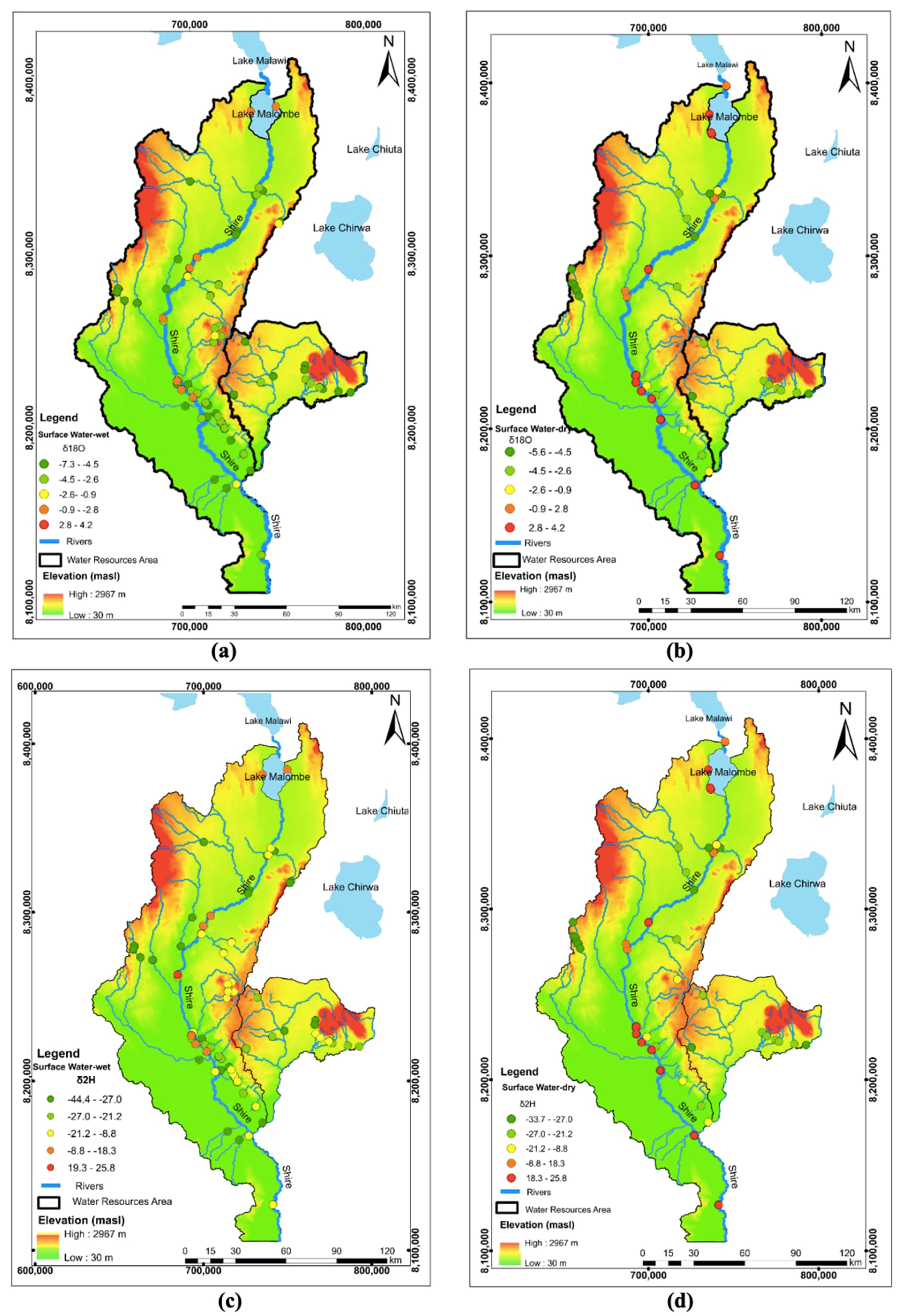
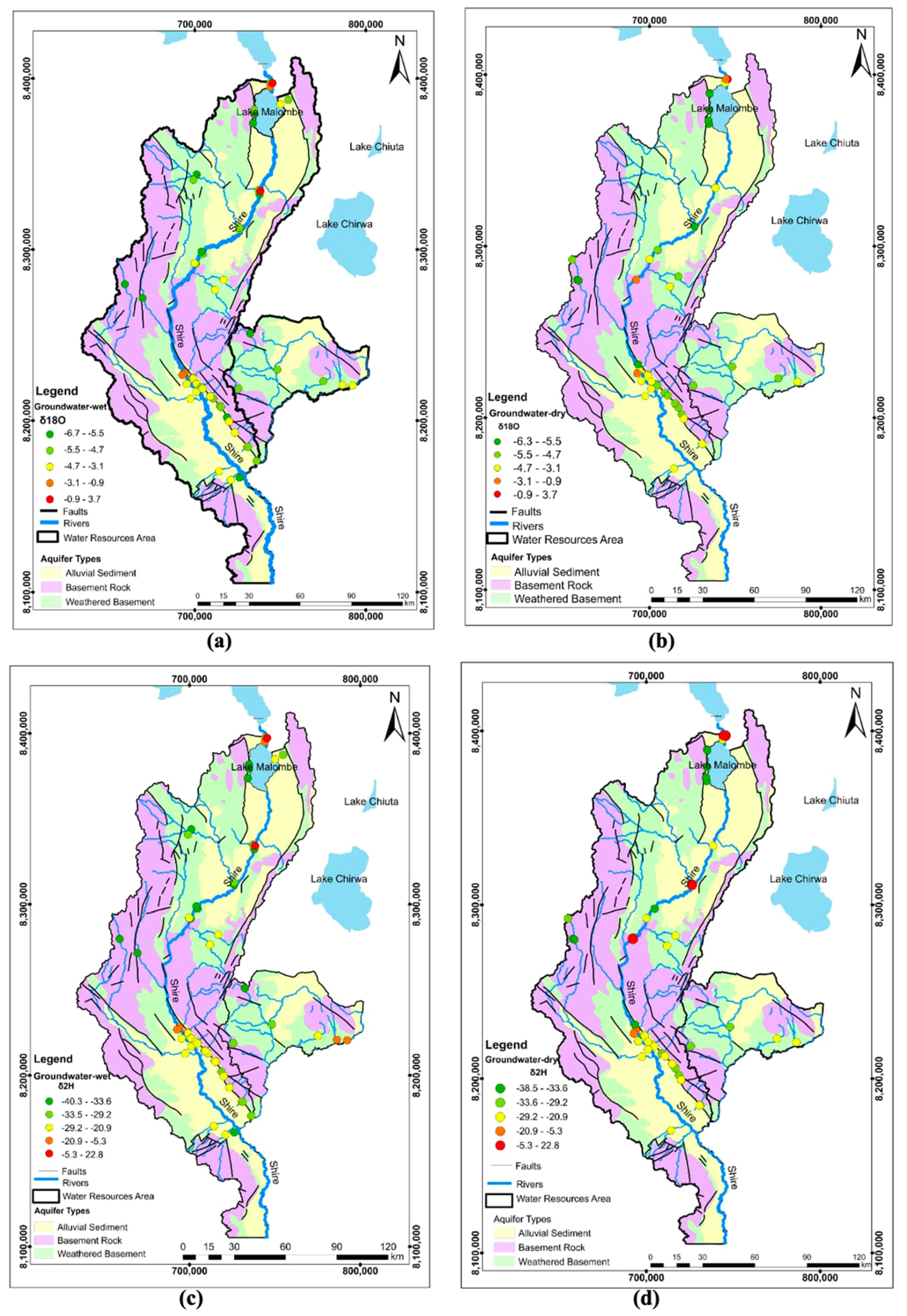
3.1.2. Isotopic Content of Surface Water and Groundwater

Surface water δ2H (n = 150 samples) ranged from −44.4‰ to +25.8‰ with a mean of −14.9‰, and δ18O from −7.3 to +4.2‰ of mean −2.8‰ (Supplementary Material (SM), Table S5). Deuterium excess ranged from −11.9‰ to +17.2‰ with a mean of 7.22‰. Most surface water samples from predominantly upland sites and a subset of the lowland sites cluster along and within prediction intervals of the local and global meteoric water lines providing strong evidence of non-evaporated precipitative recharge input into surface water bodies (Figure 4a). A significant proportion of lowland sites but relatively few upland sites deviate from the meteoric water lines and were defined by a Local Evaporation Line (LELs) of δ2H = (5.9 ± 0.1) δ18O + (1.5 ± 0.3) (Figure 4a). This provides evidence of enrichment due to evaporative fractionation occurring mostly during the hot-dry and cool-dry season that is more pronounced in Lake Malombe and other low-lying areas. The isotopic enrichment observed for Lake Malombe during the wet season supports its isotopic content is not appreciably altered by local rainfall input, but rather is predominantly influenced by Lake Malawi input (its primary source) enriched isotopic signatures retained at this season [29]. The LELs revealed influence of both evaporative processes and mixing or infiltration of groundwater through baseflow during the hot dry season. Generally, the stable isotopic variation in surface water is consistent with that of precipitation, suggesting that recent local precipitation significantly contributed to river flows in the basin. The stable isotopic content of surface water varied widely (range: 70.2‰ δ2H; 11.5‰ δ18O) consistent with local precipitation spatial variation thereby supporting local precipitation contributed largely to river flows predominantly during the wet season. The full datasets for the stable isotopes analysis results of surface water are presented in the Supplementary Material (SM) Table S9.
Groundwater δ2H (n = 133 samples) ranged from −40.3‰ to −22.8‰ with a mean of −28.4‰, and δ18O from −6.7‰ to +3.7‰ with a mean of −4.7‰ (Table S6). Deuterium excess ranged from −6.72‰ to +15.2‰ with a mean of 8.89‰. Most groundwater samples (all upland sites and most lowland sites) cluster along the local and global meteoric water lines during both dry and wet seasons (Figure 4b), an indication the Indian Ocean monsoon largely contributed to precipitative recharge input into groundwater system. A subset of samples, predominantly lowland sites, exhibited enriched isotopic signatures especially during the hot season, shifted significantly away from the meteoric water lines defined by a local evaporation line (LELg) of δ2H = (6.3 ± 0.1) δ18O + (0.9 ± 0.6) (Figure 4b). This is mostly attributed to excess δ18O as a consequence of secondary evaporative enrichment occurring either during runoff that preceded infiltration, or else within the groundwater body due to shallow groundwater phreatic evaporation. Clustering of most groundwater samples along the meteoric water lines provides strong evidence of a simple areal groundwater recharge input due to local precipitation. Hence groundwater isotopic content largely follows the LMWL with considerable variation (range: 63.1‰ δ2H; 10.4‰ δ18O), suggesting diverse groundwater recharge dominated by local precipitation input. Some isotopic deviation below the meteoric lines suggests significant evaporative enrichment of groundwater, for instance near Lake Malombe particularly during the dry season. The full datasets for the stable isotopes analysis results of groundwater are presented in the excel file in Supplementary Material (SM) Table S10.
The MNIP station stable isotope precipitation data display signatures consistent with those found in groundwater over the area marked in Figure 5 that appeared to coincide with precipitation signatures observed during December to March. This would support recharge that was predominantly occurring during the peak of the rainy season, which is reasonable to expect. Precipitation occurrence in the other months (e.g., November and April) exhibited data points outside of the groundwater area marked and supported rainfall occurring at the start and end of the rainy season, which did not appear to contribute significantly to groundwater recharge, again this is hydrologically reasonable. These precipitation data (recognizing more data are ideally required) exhibited enrichment signatures suggestive of the influence of drier-warmer conditions. It would support evapotranspiration loss of infiltrated rainwater due to the lower humidity.

3.2. Seasonal Variation in Isotopic Spatial Distributions

Spatial data support highly enriched isotopic values of surface water were observed in lowland sites, with highly depleted isotopic values more apparent in upland sites (Figure 6). Highly enriched isotopic values were distributed along the Shire River bankside area from upper to lower reaches of the Basin. Groundwater exhibited a similar pattern of enriched isotopic signatures in lowland sites and depleted isotopic signatures in upland sites (Figure 7). Highly enriched isotopic signatures were more pronounced in superficial aquifer systems compared to the basement aquifer system, as the former mostly occurred in lowlands characteristic of high evaporation effects, while the latter were largely found in uplands associated with cool temperatures, less evaporative effects and probably deeper water tables. The spatial distribution of isotopic content of groundwater appears more influenced by evaporative fractionation in near-river lower SRB sites such as wetland vicinities (e.g., the Elephant Marsh) where water tables are shallower and groundwater perhaps slow moving.

3.3. Hydrochemical Results

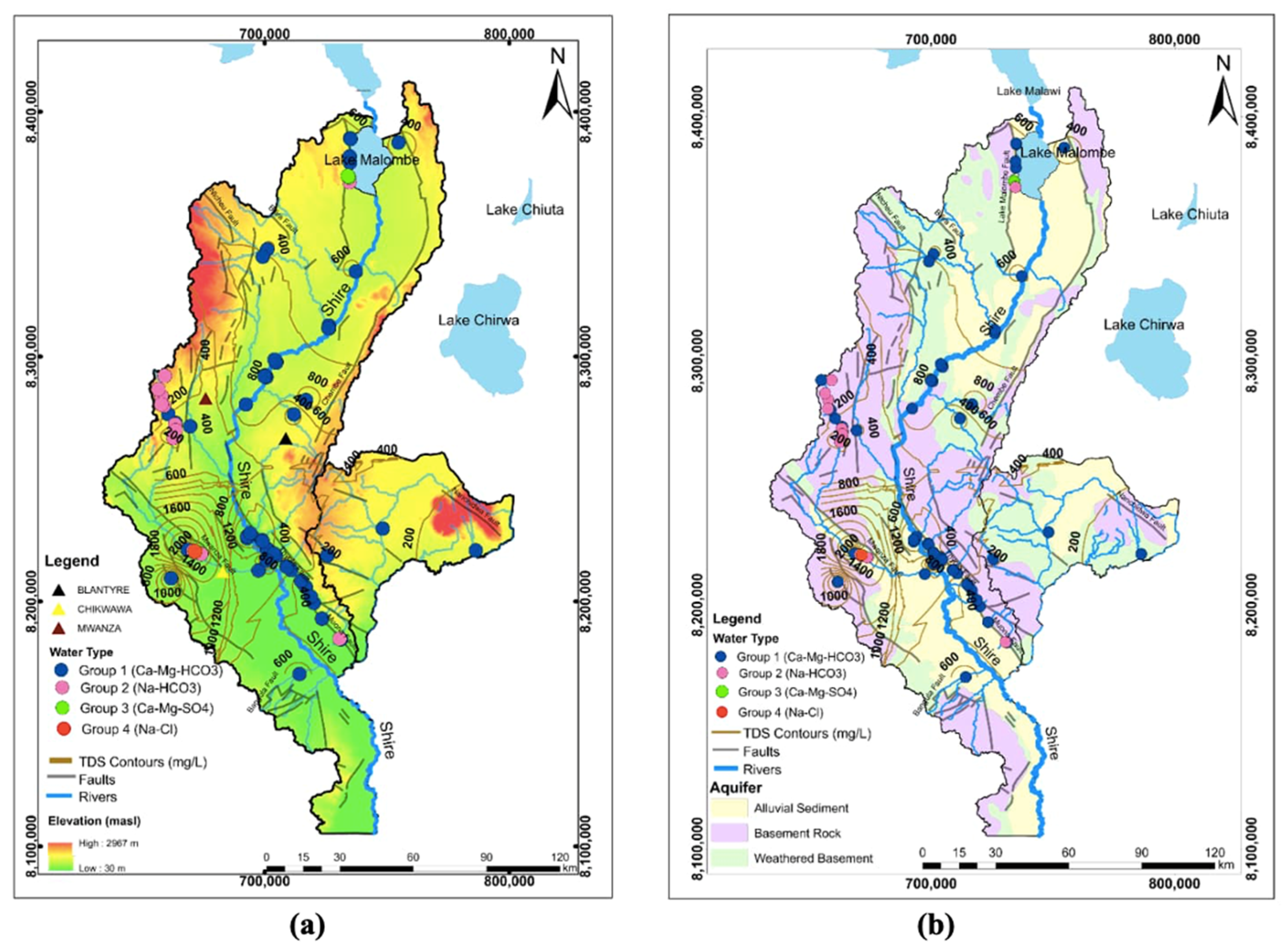
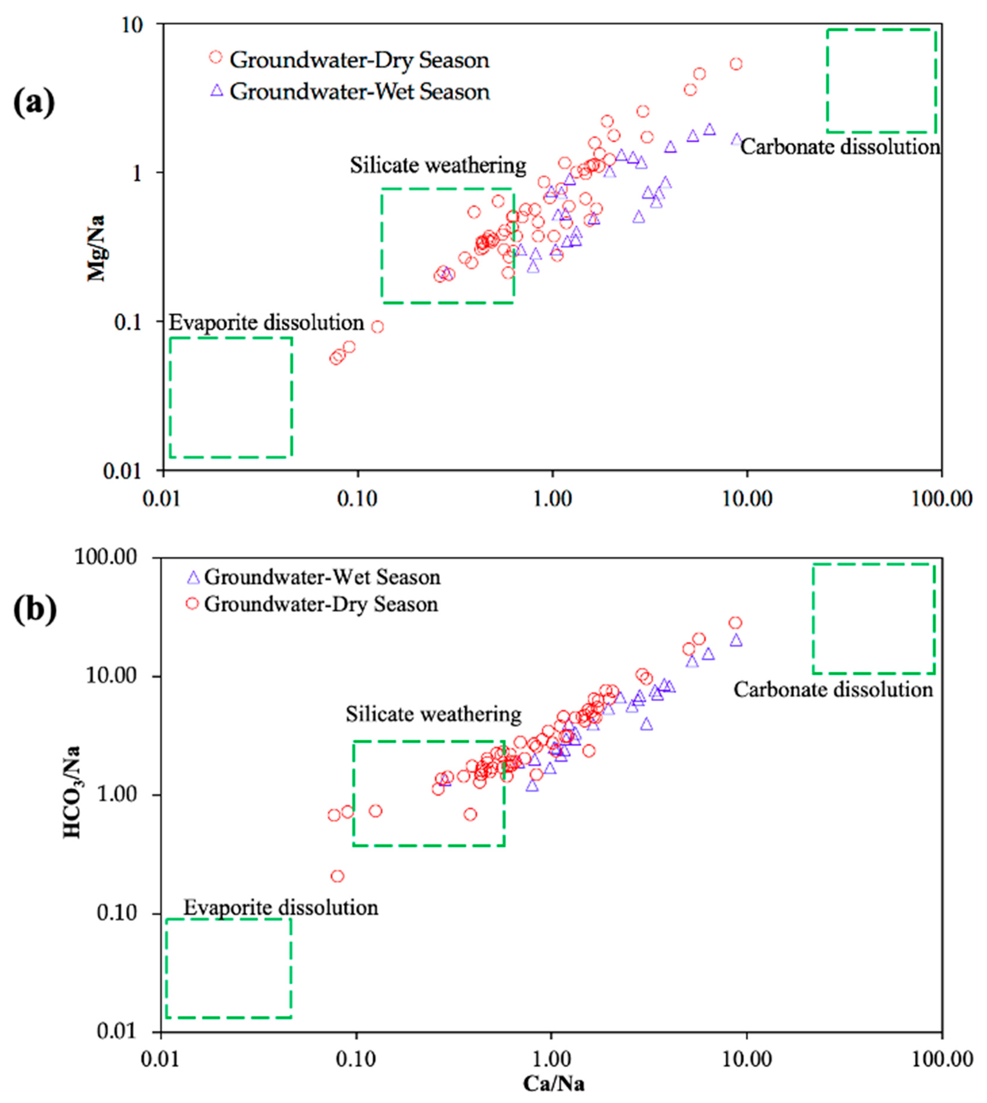
3.3.1. Hydrochemical Characteristics of Surface Water and Groundwater

Surface water ranged from pH 6.10 to 8.80 and was fresh with TDS, which was generally low varying from 13 to 603 mg/L and of mean 151 mg/L (Figure 8a; Table S7). The increased surface water dry-season mean TDS of 159 mg/L compared to wet-season mean TDS of 123 mg/L was ascribed to dilution and local rainfall rapid runoff input to surface water flows during the wet-season (Figure 8b; Table S7). Increased dry-season ranges of TDS and individual solutes could be due to greater dynamic proportionate influences of low to moderate flow rates on concentrations (recognizing though lower sample numbers for the wet season). Groundwater ranged from 5.90 to 8.70, with most groundwater slightly alkaline (71.6%). Groundwater TDS varied widely from very low to very high (19–6220 mg/L), with a mean of 576 mg/L and median of 370 mg/L (Table S7). Bicarbonate dominates the anionic content with modest to low sulphate, low chloride and negligible nitrate. Calcium and sodium are the dominant cations. Solute concentrations are increased in groundwater compared to surface water and attributed to increased residence time and rock matrix interaction and dissolution (Figure 8b). Still, groundwater concentrations generally compare favourably, although not always compliant with World Health Organisation (WHO) guidance. For instance, drinking water was characterised with good palatability at <600 mg/L TDS (70.2% of samples), but becoming increasingly unpalatable (and brackish) at >1000 mg/L TDS (8.3% of samples). Wet-season groundwater tended to display lower ranges in TDS and individual solutes than dry-season (Figure 8b; Table S7). Similar to surface water this could be due to lower sample numbers, but could be seasonally related with more pronounced proportionate influence of table variations across the dry season. Although TDS and individual solute groundwater concentrations were mostly within the range of dry-season variations, wet-season TDS, bicarbonate, calcium and sulphate tended to be increased (Figure 8b). Controlling reasons were not particularly clear with greater sample numbers required to confirm trends. Generally, though greater seasonal dynamic in groundwater concentrations may be expected in boreholes screened closer to the water table where seasonal variation in water levels and recharge inputs are less damped. The full datasets for the hydrochemical analysis results of surface water and groundwater are presented in the Supplementary Material (SM) Tables S11 and S12, respectively.

3.3.2. Spatial Distribution

The groundwater types classification based on Piper plot (Figure 9) indicates most groundwater samples plot in the left diamond quadrant Group 1 water type evidencing a predominant non-evaporated local precipitative recharge contribution to the groundwater system. The Piper plot supports cation exchange occurrence especially in lowland western Shire River groundwater, contributing to Group 2 water type dominant occurrence per Figure 10. The Group 1 water type (Ca-Mg-HCO3) in groundwater was predominant across the SRB and more pronounced east of the Shire River (Figure 10). It is particularly characteristic of low TDS (<500 mg/L) prevalent in uplands and is the typical water type for recent recharge water with limited modification by geological interactions. There is an increasing trend towards the lowlands of Group 2 (Na-HCO3) type groundwater that occurred relatively sparsely across the basin, but was most prevalent west of the Shire River middle reaches in the Chikwawa and Mwanza districts. It was characterised by higher TDS concentration (>500 mg/L), and was more pronounced in the lowlands and was taken to be indicative of groundwaters of longer residence time having undergone cation exchange leading to characteristic increased sodium contents. Occurrence of Group 3 water type (Ca-Mg-SO4) and Group 4 water type (Na-Cl) was rather scant, the former occurring north of the Shire River upper reaches around Lake Malombe and the latter to the north-west of the Shire River lower reaches, typically a lowland area of high TDS water. The composition is suggestive of older groundwater, and or groundwater that has been subjected to evaporative concentration. This would accord with the higher and most abrupt increases in TDS tended to occur in the lowland plains to the west of the Shire River, especially the lower reaches. Groundwater TDS broadly followed the topography increasing towards the lowlands according with the general direction of basin groundwater flow draining towards the lowland plains.
The bivariate ratio plots support that the majority of groundwater sampled was predominantly influenced by silicate weathering and carbonate dissolution, rather than evaporite dissolution (Figure 11). Na/Cl molar ratios deviated from the 1:1 ratio supporting that observed sodium increases in groundwater were most likely due to silicate weathering and subsequent increased sodium from cation exchange.
Overall and consistent with the wider SRB groundwater literature [36], observed water types and their relative occurrence and distribution support a groundwater geochemical evolution dominated by silicate weathering, carbonate dissolution, cation exchange and evaporative concentration with limited influence of evaporite dissolution. This is consistent with the predominance of silicate source rocks and limited occurrence of evaporites (halite, gypsum, etc.). The latter are typically associated with any lower permeability, poorly flushed, shaly or marly deposits occurring. This may include influence from laterally adjoining or underlying formations in hydraulic continuity such as the Karoo formation sandstone and shales [48].

3.4. Groundwater—Hydrochemical and Isotopic Evidences Combined

A plot of wet/dry season isotope signatures with points classified into groundwater types confirms Group 1 water type follows the meteoric water lines, but with a few samples deviating (Figure 12). These samples that shift from the meteoric water lines exhibit evaporative enrichment associated with higher TDS values and corresponded to lowland sites in the hot dry season (Figure 4). Though the bulk of data generally endorses a young water occurrence predominantly influenced by non-evaporated local rainfall recharge. For the few sites outside the prediction error band, their higher TDS values provide evidence of enrichment due to evaporative fractionation. The other water type groups (2, 3 and 4) plotted along the meteoric lines and were indicative of meteoric origin and negligible evaporation fractionation effects.

4. Discussion

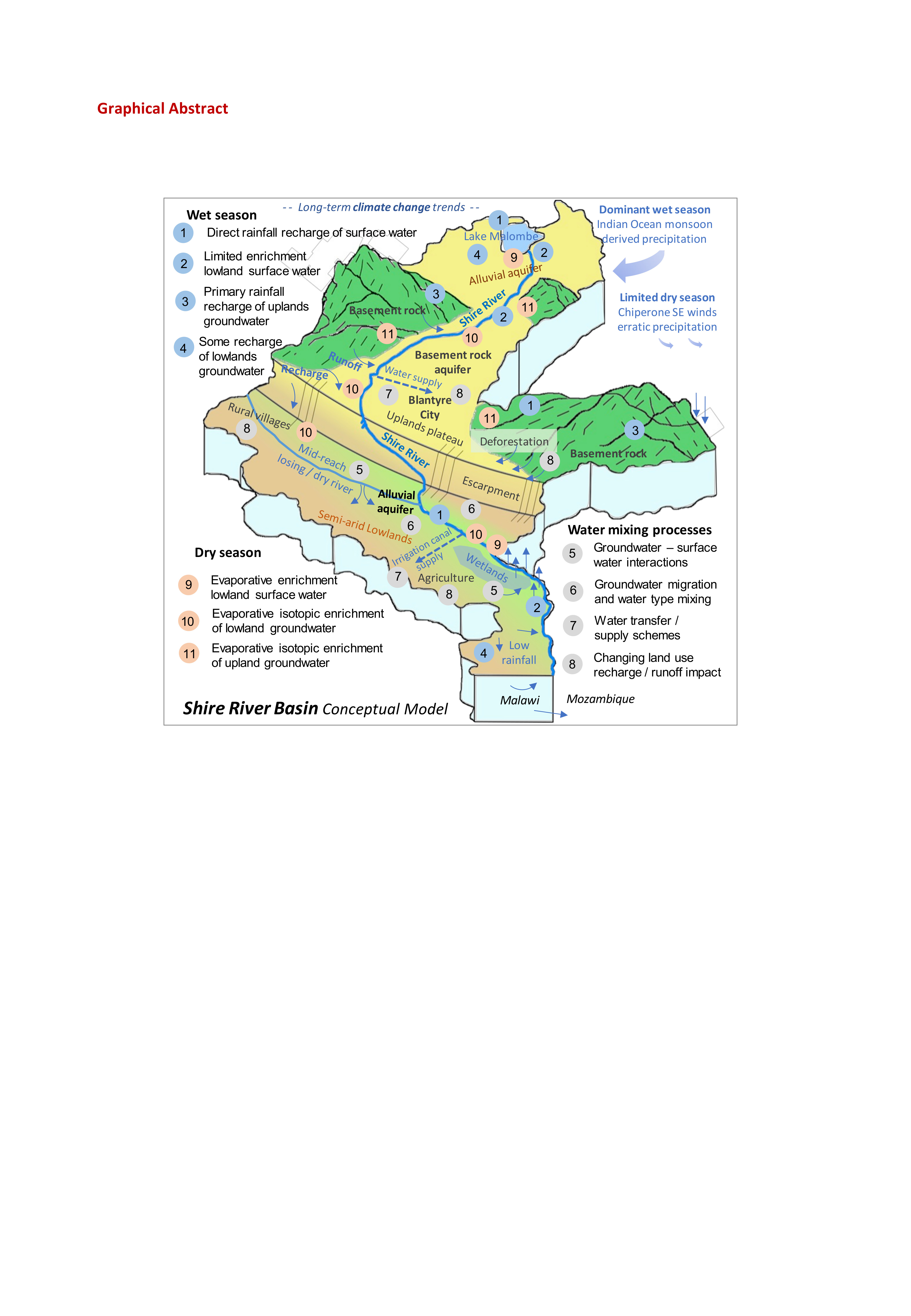
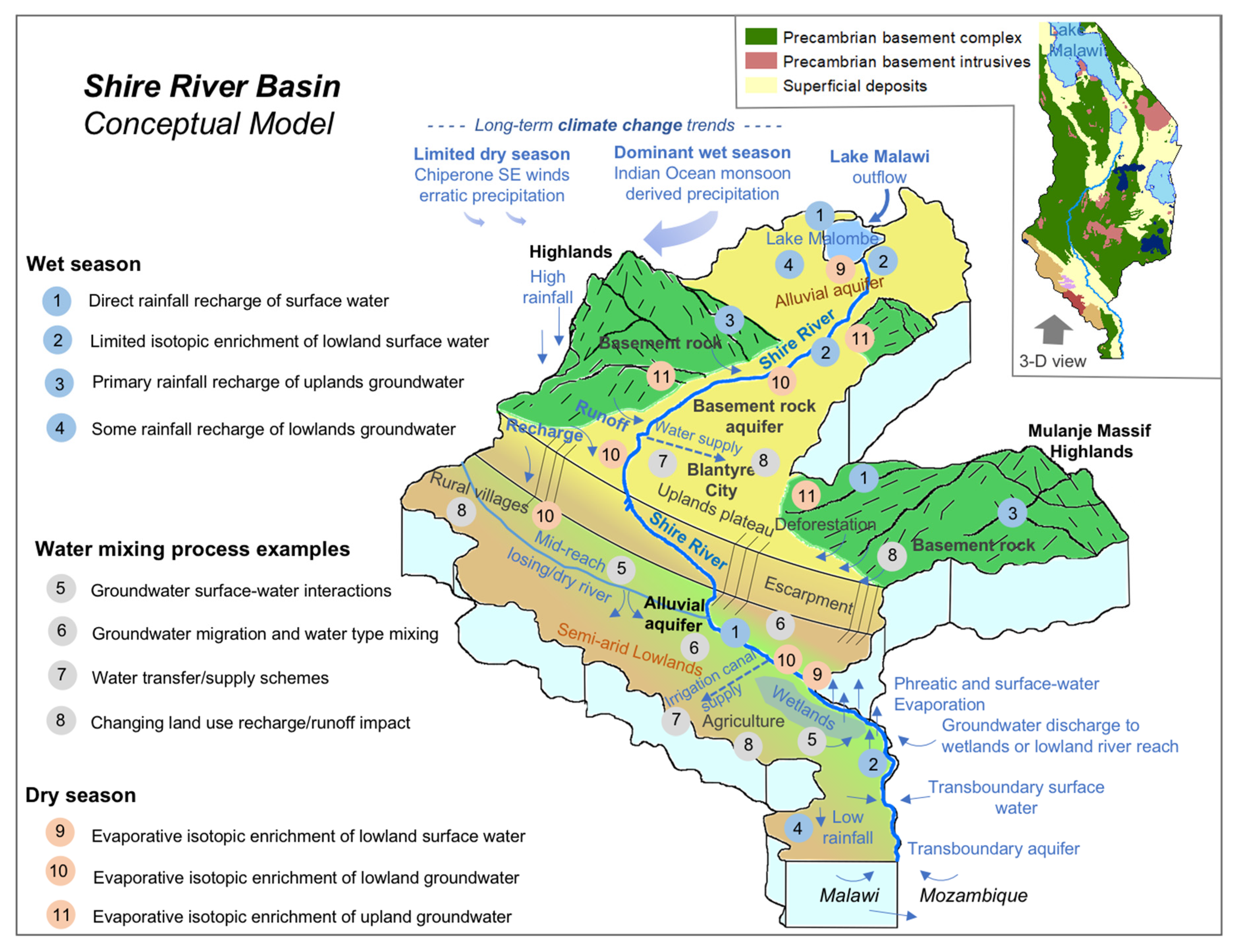
4.1. System Conceptualisation and Isotopic Diagnostic Tools

The mutual reinforcing of isotopic signature and hydrochemical results and consistency with hydro(geo)logical expectations enabled development of the SRB system conceptual model shown in Figure 13. Key signature trends providing diagnostic insight into water provenance and controlling processes are illustrated. Marked variations between wet and dry seasons justify the inclusion of seasonality in the model developed. The conceptualisation also highlights where isotopic water tracing may enhance understanding of key water-mixing scenario. These include predominantly natural scenario, for instance seasonally variant groundwater–surface water interactions, as well as anthropogenic or engineered water mixing scenario arising from say water-transfer schemes, or changing land use such as deforestation. The basin-scale conceptualisation provides the foundation necessary for future studies or scheme assessments that may use departures in isotopic signatures from the benchmark baseline established. The forensic power of isotopes (including other elemental isotopes in due time and other tracers, e.g., noble gases) to differentiate water source provenance is fundamental to IWRM schemes that frequently involve water mixing.
Key isotopic diagnostic tool capability demonstrated and inherent to our conceptual model formulation include:
  • Distinct surface water dry-season enrichment and wet-season depletion, but with minor retention of enriched isotopic signatures ascribed to Lake Malawi influences;
  • Isotopic signature corroboration of wet-season river flows mostly arising from local precipitation, with dry-season flows supported by increased groundwater contributions;
  • Precipitation signatures consistent with expected isotopic composition for Indian Ocean monsoon derived precipitation that forms the predominant water input to the basin;
  • Groundwater isotopic signatures followed a LMWL of limited spread taken to signify recharge by local precipitation occurs predominantly in core, rather than peripheral, wet-season months;
  • Although few dry-season groundwater samples displayed evaporative enrichment, isotopic seasonality was more pronounced in the lowlands.

4.2. Benefits to IWRM

The study develops not only isotopic forensic tool capability, but also documents the current isotopic baseline benchmark condition against which future change to the SRB water resource may be measured. This study and planned similar projects will valuably underpin IWRM implementation in the SRB and river basins elsewhere in Malawi including the Linthipe [29], Bua, Dwangwa, North Rukuru and Lufilya where the Government plans to undertake catchment restoration and improve water security, agricultural productivity and rural livelihoods, notably under the World Bank funded Malawi Watershed Services Improvement Project (MWASIP). The project has flagged a critical need for an integrated cross-sectoral approach for water-resource planning and management at river basin level in order to increase efficiency in the use of resources and capacities and thereby multiply impacts.
Identified isotope tool benefits to IWRM implementation in the SRB water-resource policy development include:
  • Assessment of ‘water mixing’ occurring naturally, or within engineered IWRM schemes that may enable identification and targeted protection of sources waters;
  • Improved Water Resource Unit (WRU) management—this includes both individual and integrated WRU management in for instance nested monitoring of subcatchments and downstream catchment aggregates and linked groundwater bodies (mimicking approaches inherent to the European Water Framework Directive);
  • Diagnostic assessment of land use change (e.g., deforestation and urban development) influence upon the balance of runoff to surface water, versus infiltration and recharge to groundwater [43];
  • Assessment of wet/dry season dynamics recognizing significant contrast in seasonal precipitation and water availability to address increasing water-supply demands and environmental needs;
  • Insight to groundwater—surface water interactions—baseflow support to rivers, ecosystems, and river abstractions for cities and agriculture, versus quite common mid-reach influent river recharge to Malawian groundwater;
  • Surface water and groundwater resource storage capacity and their dynamic management (e.g., low storage inherent to basement rock pose a fundamental resource constraint);
  • Irrigation scheme impact assessment—interaction with underlying groundwater resource including salinisation concerns—e.g., Shire Valley Irrigation Project [56];
  • Transboundary aquifer and surface-water management—the SRB position upstream of sensitive downstream international water use [46], we have undertaken a recent (2019) transboundary Lower SRB isotope study in neighbouring Mozambique;
  • Climate change management—risks to water-resource sustainability from long-term uncertainties in precipitation inputs and runoff, evaporation and recharge balances—climate change concern continues to fundamentally drive the CJF (Climate Justice Fund) Programme.

Supplementary Materials

The following are available online at https://www.mdpi.com/2073-4441/12/5/1410/s1, Figure S1: Mean monthly (a) rainfalls and (b) temperatures for the Shire River Basin between the period 1999 to 2019, Table S1: Malawi-Network of Isotopes in Precipitation (MNIP) Stations, Table S2: Global Network of Isotopes in Precipitation (GNIP) Stations close to the MNIP Stations, Table S3: Statistical summary of isotopic composition of precipitation from MNIP stations, Table S4: Statistical summary of isotopic composition of precipitation from surrounding Global Network of Isotopes in Precipitation (GNIP) Stations, Table S5: Statistical summary of isotopic composition of surface water from Shire River Basin, Table S6: Statistical summary of isotopic composition of groundwater from Shire River Basin, Table S7: Statistical summary of hydrochemical analysis results of surface water from Shire River Basin, Table S8: List of abbreviations, Table S9: Isotopes data-GW, Table S10: Isotopes data-SW, Table S11: Hydrochemical dataSW, Table S12: Hydrochemical dataGW.

Author Contributions

Conceptualization, L.C.B., M.O.R., R.M.K., A.S.K.Z., C.F.; methodology, L.C.B., M.O.R. and R.M.K.; validation, L.C.B., A.S.K.Z.; formal analysis, L.C.B and M.O.R.; investigation, L.C.B. and M.O.R.: resources, L.C.B. and P.P.; data curation, L.C.B., A.S.K.Z.; writing—original draft preparation, L.C.B. writing—review and editing, M.O.R., L.C.B., R.M.K., C.F., G.C., P.P. and M.N.; visualization, L.C.B., C.K., M.O.R. and C.F.; supervision, R.M.K. and M.O.R.; project administration, R.M.K., S.K., P.P., M.N. and L.C.B.; funding acquisition, R.M.K., L.C.B., S.K. and P.P. All authors have read and agreed to the published version of the manuscript.

Funding

We gratefully acknowledge the funding by the Scottish Government Climate Justice Fund-Water Futures Programme research grant HN-CJF-03 awarded to the University of Strathclyde and the International Atomic Energy Agency (IAEA) under the Malawi Technical Cooperation (TC) Projects’ grants (MLW/7/001: MLW/7/002/MLW/7/003), awarded to the Government of Malawi (Department of Water Resources in the Ministry of Agriculture, Irrigation and Water Development). We also acknowledge the financial contribution we received from the Government of Malawi.

Acknowledgments

We acknowledge the technical and administrative support rendered to us by the BASEflow organization based in Malawi.

Conflicts of Interest

The authors declare no conflict of interest.

References

  1. Wassenaar, L.I.; Van Wilgenburg, S.L.; Larson, K.; Hobson, K.A. A groundwater isoscapes (δD, δ18O) for Mexico. J. Geochem. Explor. 2009, 102, 123–136. [Google Scholar] [CrossRef]
  2. Chavula, G.M.S. Malawi. In Groundwater Availability and Use in Sub-Saharan Africa: A Review of Fifteen Countries; Pavelic, P., Giordano, M., Keraita, B., Ramesh, V., Rao, T., Eds.; International Water Management Institute: Colombo, Sri Lanka, 2012; Available online: http://www.iwmi.cgiar.org/Publications/Books/PDF/groundwater_availability_and_use_in_sub-saharan_africa_a_review_of_15_countries.pdf (accessed on 15 October 2019).
  3. Martinez, J.L.; Raiber, M.; Cox, M. Assessment of groundwater–surface water interaction using long-term hydrochemical data and isotope hydrology: Headwaters of the Condamine River, Southeast Queensland, Australia. Sci. Total. Environ. 2015, 536, 499–516. [Google Scholar] [CrossRef] [PubMed]
  4. Gonçalvès, J.; Vallet-Coulomb, C.; Petersen, J.; Bruno, H.; Deschamps, P. Declining water budget in a deep regional aquifer assessed by geostatistical simulations of stable isotopes: Case study of the Saharan “Continental Intercalaire”. J. Hydrol. 2015, 531, 821–829. [Google Scholar] [CrossRef]
  5. Kalin, R.M.; Long, A. Application of hydrogeochemical modelling for validation of hydrologic flow modelling in the Tucson Basin Aquifer, Arizona, AZ, USA. In Mathematical Models and Their Applications to Isotope Studies in Groundwater Hydrology; IAEA: Vienna, Austria, 1994; pp. 209–254. Available online: https://inis.iaea.org/Search/search.aspx?orig_q=RN:26036831 (accessed on 24 January 2020).
  6. Kalin, R.M. Basic concepts and formulations for isotope-geochemical process investigations, procedures, and methodologies of geochemical modelling of groundwater systems. In Manual on Mathematical Models in Isotope Hydrology; Yurtsever, Y., Ed.; IAEA: Vienna, Austria, 1995; Volume 910, pp. 155–206. Available online: http://www-naweb.iaea.org/napc/ih/documents/TECDOCS/TECDOC%200910%20Mathematical%models%201996.PDF (accessed on 24 January 2020).
  7. Wallin, B.; Gaye, C.; Gourcy, L.; Aggarwal, P. Isotope Methods for Management of Shared Aquifers in Northern Africa. Ground Water 2005, 43, 744–749. [Google Scholar] [CrossRef] [PubMed]
  8. Gaye, C.B.; Tindimugaya, C. Review: Challenges and opportunities for sustainable groundwater management in Africa. Hydrogeol. J. 2018, 27, 1099–1110. [Google Scholar] [CrossRef]
  9. Balagizi, C.M.; Kasereka, M.M.; Cuoco, E.; Liotta, M. Influence of moisture source dynamics and weather patterns on stable isotopes ratios of precipitation in Central-Eastern Africa. Sci. Total Environ. 2018, 628, 1058–1078. [Google Scholar] [CrossRef]
  10. Kotchoni, D.O.V.; Vouillamoz, J.-M.; Lawson, F.M.A.; Adjomayi, P.; Boukari, M.; Taylor, R.G. Relationships between rainfall and groundwater recharge in seasonally humid Benin: A comparative analysis of long-term hydrographs in sedimentary and crystalline aquifers. Hydrogeol. J. 2018, 27, 447–457. [Google Scholar] [CrossRef] [Green Version]
  11. Resende, T.C.; Longuevergne, L.; Gurdak, J.J.; Leblanc, M.; Favreau, G.; Ansems, N.; Van Der Gun, J.; Gaye, C.B.; Aureli, A. Assessment of the impacts of climate variability on total water storage across Africa: Implications for groundwater resources management. Hydrogeol. J. 2018, 27, 493–512. [Google Scholar] [CrossRef] [Green Version]
  12. Abdalla, O. Groundwater recharge/discharge in semi-arid regions interpreted from isotope and chloride concentrations in north White Nile Rift, Sudan. Hydrogeol. J. 2008, 17, 679–692. [Google Scholar] [CrossRef]
  13. Babaye, M.S.A.; Orban, P.; Ousmane, B.; Favreau, G.; Brouyère, S.; Dassargues, A. Characterization of recharge mechanisms in a Precambrian basement aquifer in semi-arid south-west Niger. Hydrogeol. J. 2018, 27, 475–491. [Google Scholar] [CrossRef] [Green Version]
  14. Faye, S.C.; Diongue, M.L.; Pouye, A.; Gaye, C.B.; Travi, Y.; Wohnlich, S.; Faye, S.; Taylor, R.G. Tracing natural groundwater recharge to the Thiaroye aquifer of Dakar, Senegal. Hydrogeol. J. 2019, 27, 1067–1080. [Google Scholar] [CrossRef] [Green Version]
  15. Edmunds, W.M. Palaeoclimate and groundwater evolution in Africa—Implications for adaptation and management. Hydrol. Sci. J. 2009, 54, 781–792. [Google Scholar] [CrossRef]
  16. Fontes, J.-C.; Andrews, J.N.; Edmunds, W.M.; Guerre, A.; Travi, Y. Paleorecharge by the Niger River (Mali) Deduced from groundwater geochemistry. Water Resour. Res. 1991, 27, 199–214. [Google Scholar] [CrossRef]
  17. Akpataku, K.V.; Rai, S.P.; Gnazou, M.D.-T.; Tampo, L.; Bawa, L.M.; Djaneye-Boundjou, G.; Faye, S. Hydrochemical and isotopic characterization of groundwater in the southeastern part of the Plateaux Region, Togo. Hydrol. Sci. J. 2019, 64, 983–1000. [Google Scholar] [CrossRef]
  18. Walker, D.; Parkin, G.; Gowing, J.; Haile, A.T. Development of a Hydrogeological Conceptual Model for Shallow Aquifers in the Data Scarce Upper Blue Nile Basin. Hydrology 2019, 6, 43. [Google Scholar] [CrossRef] [Green Version]
  19. Bahir, M.; Ouhamdouch, S.; Carreira, P.M.; Chkir, N.; Zouari, K. Geochemical and isotopic investigation of the aquifer system under semi-arid climate: Case of Essaouira basin (Southwestern Morocco). Carbonates Evaporites 2016, 33, 65–77. [Google Scholar] [CrossRef]
  20. Durowoju, O.; Butler, M.; Ekosse, G.-I.; Odiyo, J. Hydrochemical Processes and Isotopic Study of Geothermal Springs within Soutpansberg, Limpopo Province, South Africa. Appl. Sci. 2019, 9, 1688. [Google Scholar] [CrossRef] [Green Version]
  21. Kebede, S.; Abdalla, O.; Sefelnasr, A.; Tindimugaya, C.; Mustafa, O. Interaction of surface water and groundwater in the Nile River basin: Isotopic and piezometric evidence. Hydrogeol. J. 2016, 25, 707–726. [Google Scholar] [CrossRef]
  22. Owor, M.; Taylor, R.; Mukwaya, C.; Tindimugaya, C. Groundwater/surface-water interactions on deeply weathered surfaces of low relief: Evidence from Lakes Victoria and Kyoga, Uganda. Hydrogeol. J. 2011, 19, 1403–1420. [Google Scholar] [CrossRef]
  23. Nivet, F.; Bergonzini, L.; Mathé, P.-E.; Noret, A.; Monvoisin, G.; Majule, A.; Williamson, D. Influence of the balance of the intertropical front on seasonal variations of the isotopic composition in rainfall at Kisiba Masoko (Rungwe Volcanic Province, SW, Tanzania). Isot. Environ. Heal. Stud. 2018, 54, 352–369. [Google Scholar] [CrossRef] [PubMed]
  24. Geris, J.; Comte, J.C.; Franchi, F.; Petros, A.; Thato Selepeng, A.; Dikgola, K.; Kurugundla, C.; Villholth, K. From droughts to floods in Sub-Saharan regions; spatial and temporal patterns in hydrological response and water quality. In EGU General Assembly Conference Abstracts; EGU: Munich, Germany, 2018; Volume 20, p. 10294. Available online: https://meetingorganizer.copernicus.org/EGU2018/EGU2018-10294-1.pdf (accessed on 15 January 2020).
  25. Guendouz, A.; Moulla, A.S.; Rémini, B.; Michelot, J.L. Hydrochemical and isotopic behaviour of a Saharan phreatic aquifer suffering severe natural and anthropic constraints (case of Oued-Souf region, Algeria). Hydrogeol. J. 2006, 14, 955–968. [Google Scholar] [CrossRef]
  26. Tarki, M.; Ben Hammadi, M.; El Mejri, H.; Dassi, L. Assessment of hydrochemical processes and groundwater hydrodynamics in a multilayer aquifer system under long-term irrigation condition: A case study of Nefzaoua basin, southern Tunisia. Appl. Radiat. Isot. 2016, 110, 138–149. [Google Scholar] [CrossRef] [PubMed]
  27. Ganyaglo, S.Y.; Osae, S.; Akiti, T.; Armah, T.; Gourcy, L.; Vitvar, T.; Ito, M.; Otoo, I.A. Application of geochemical and stable isotopic tracers to investigate groundwater salinity in the Ochi-Narkwa Basin, Ghana. Hydrol. Sci. J. 2017, 62, 1301–1316. [Google Scholar] [CrossRef]
  28. Ré, V.; Faye, S.C.; Faye, A.; Faye, S.; Gaye, C.B.; Sacchi, E.; Zuppi, G.M. Water quality decline in coastal aquifers under anthropic pressure: The case of a suburban area of Dakar (Senegal). Environ. Monit. Assess. 2010, 172, 605–622. [Google Scholar] [CrossRef] [PubMed]
  29. Banda, L.; Rivett, M.; Kalin, R.M.; Zavison, A.; Phiri, P.; Kelly, L.; Chavula, G.; Kapachika, C.; Nkhata, M.; Kamtukule, S.; et al. Water–Isotope Capacity Building and Demonstration in a Developing World Context: Isotopic Baseline and Conceptualization of a Lake Malawi Catchment. Water 2019, 11, 2600. [Google Scholar] [CrossRef] [Green Version]
  30. Gonfiantini, R.; Zuppi, G.M.; Eccles, D.H.; Ferro, W. Isotope investigation of Lake Malawi. In Isotopes in Lake Studies; International Atomic Energy Agency; IAEA: Vienna, Austria, 1979; Available online: https://inis.iaea.org/search/search.aspx?orig_q=RN:12581226 (accessed on 10 January 2020).
  31. Kalebe, Y.N. Chemical and Isotopic Composition of Thermal Waters in Northern Part of Malawi. Available online: https://orkustofnun.is/gogn/unu-gtp-report/UNU-GTP-2017-13.pdf (accessed on 20 December 2019).
  32. Kambuku, D.; Tsujimura, M.; Kagawa, S. Groundwater recharge and flow processes as revealed by stable isotopes and geochemistry in fractured Hornblende-biotite-gneiss, Rivirivi Catchment, Malawi. Afr. J. Environ. Sci. Technol 2018, 12, 1–14. [Google Scholar]
  33. Kambuku, D.; Tsujimura, M.; Kagawa, S.; Mdala, H. Corroborating stable isotopic data with pumping test data to investigate recharge and groundwater flow processes in a fractured rock aquifer, Rivirivi Catchment, Malawi. Environ. Earth Sci. 2018, 77, 226. [Google Scholar] [CrossRef]
  34. Mapoma, H.W.T.; Xie, X.; Zhang, L. Redox control on trace element geochemistry and provenance of groundwater in fractured basement of Blantyre, Malawi. J. Afr. Earth Sci. 2014, 100, 335–345. [Google Scholar] [CrossRef]
  35. Missi, C.; Atekwana, E.A. Physical, chemical and isotopic characteristics of groundwater and surface water in the Lake Chilwa Basin, Malawi. J. Afr. Earth Sci. 2020, 162, 103737. [Google Scholar] [CrossRef]
  36. Monjerezi, M.; Vogt, R.D.; Aagaard, P.; Saka, J.D.K. Using δ87Sr/δ86Sr, δ18O and δ2H isotope data along with major chemistry composition to assess groundwater salinization in lower Shire River Valley, Malawi. Appl. Geochem. 2011, 26, 2201–2214. [Google Scholar] [CrossRef]
  37. Spigel, R.; Coulter, G. Comparison of Hydrology and Physical Limnology of the East African Great Lakes: Tanganyika, Malawi, Victoria, Kivu and Turkana (with reference to some North American Great Lakes). Limnol. Climatol. Paleoclimatol. East Afr. Lakes 2019, 103–139. [Google Scholar] [CrossRef]
  38. Government of Malawi. Malawi Hydrogeological Atlas; Ministry of Agriculture, Irrigation and Water Development: Lilongwe, Malawi, 2019.
  39. MoAIWD (Ministry of Agriculture, Irrigation and Water Development). State of the Basin Report for Shire River Basin: SRBMP–Sub-Component A1: Development of a Basin Planning Framework. June 2016. Available online: http://www.shirebasin.mw/index.php?option=com_joomdoc&task=document.download&path=State%20of%20the%20Basin%20Report.pdf&Itemid=559 (accessed on 20 January 2020).
  40. Malawi Water Department. Shire River Basin Atlas. Lilongwe, Malawi; Ministry of Agriculture, Irrigation & Water Development: Lilongwe, Malawi, 2016.
  41. Kelly, L.; Kalin, R.M.; Bertram, D.; Kanjaye, M.; Nkhata, M.; Sibande, H. Quantification of Temporal Variations in Base Flow Index Using Sporadic River Data: Application to the Bua Catchment, Malawi. Water 2019, 11, 901. [Google Scholar] [CrossRef] [Green Version]
  42. Kalin, R.M.; Mwanamveka, J.; Coulson, A.; Robertson, D.J.C.; Clark, H.; Rathjen, J.; Rivett, M. Stranded Assets as a Key Concept to Guide Investment Strategies for Sustainable Development Goal 6. Water 2019, 11, 702. [Google Scholar] [CrossRef] [Green Version]
  43. Rivett, M.O.; Budimir, L.; Mannix, N.; Miller, A.V.M.; Addison, M.J.; Moyo, P.; Wanangwa, G.J.; Phiri, O.L.; Songola, C.E.; Nhlema, M.; et al. Responding to Salinity in a Rural African Alluvial Valley Aquifer System: To Boldly Go beyond the World of Hand-Pumped Groundwater Supply? Sci. Total Environ. 2019, 653, 1005–1024. [Google Scholar] [CrossRef] [PubMed] [Green Version]
  44. Government of the Republic of Malawi. Malawi Economic Growth Strategy; Government of the Republic of Malawi: Lilongwe, Malawi, 2014.
  45. MoAIWD (Ministry of Agriculture, Irrigation and Water Development). Shire Valley Irrigation Project. Environmental and Social Management Plan for Phase 1. 2017. Available online: http://documents.worldbank.org/curated/en/271121495837484038/pdf/SFG3386-REVISED-REPLACEMENT-EA-P158805-PUBLIC-Disclosed-8-8-2017.pdf (accessed on 3 January 2020).
  46. Fraser, C.M.; Kalin, R.M.; Rivett, M.; Nkhata, M.; Kanjaye, M. A national approach to systematic transboundary aquifer assessment and conceptualisation at relevant scales: A Malawi case study. J. Hydrol. Reg. Stud. 2018, 20, 35–48. [Google Scholar] [CrossRef]
  47. Coulibaly, J.Y.; Mbow, C.; Sileshi, G.W.; Beedy, T.; Kundhlande, G.; Musau, J. Mapping Vulnerability to Climate Change in Malawi: Spatial and Social Differentiation in the Shire River Basin. Am. J. Clim. Chang. 2015, 4, 282–294. [Google Scholar] [CrossRef] [Green Version]
  48. Bath, A.H. Hydrochemistry in Groundwater Development; Report No. WD/OS/80/20; Institute of Geological Sciences: London, UK, 1980. [Google Scholar]
  49. Mkandawire, P.P. Groundwater resources of Malawi. In Proceedings of the International Workshop on Managing Shared Aquifer Resources in Africa, Tripoli, Libya, 2–4 June 2002. [Google Scholar]
  50. Mulwafu, W.; Chavula, G.; Chipeta, C.; Ferguson, A.; Chilima, G.; Nkhoma, B. The Status of Water Demand Management in Malawi and Strategies for promoting it. Zomba, Malawi; University of Malawi, Chancellor College: Zomba, Malawi, 2008; Available online: http://citeseerx.ist.psu.edu/viewdoc/download?doi=10.1.1.194.8844&rep=rep1&type=pdf (accessed on 10 January 2020).
  51. Addison, M.J.; Rivett, M.O.; Robinson, H.; Fraser, A.; Miller, A.M.; Phiri, P.; Mleta, P.; Kalin, R.M. Fluoride occurrence in the lower East African Rift System, Southern Malawi. Sci. Total. Environ. 2020, 712, 136260. [Google Scholar] [CrossRef]
  52. Back, J.O.; Rivett, M.; Hinz, L.B.; Mackay, N.; Wanangwa, G.J.; Phiri, O.L.; Songola, C.E.; Thomas, M.A.; Kumwenda, S.; Nhlema, M.; et al. Risk assessment to groundwater of pit latrine rural sanitation policy in developing country settings. Sci. Total. Environ. 2018, 613, 592–610. [Google Scholar] [CrossRef] [Green Version]
  53. Government of the Republic of Malawi. Final Report Component B—Catchment Management. In Shire River Basin Management Programme Phase 1 Project; Government of the Republic of Malawi: Lilongwe, Malawi, 2017. [Google Scholar]
  54. Smith-Carrington, A.K.; Chilton, P.J. Groundwater Resources of Malawi; Overseas Development Administration Institute of Geological Sciences: London, UK, 1983; Available online: http://resources.bgs.ac.uk/sadcreports/malawi1983smithcarringtonmalawigwresources.pdf (accessed on 8 October 2019).
  55. Peel, M.C.; Finlayson, B.L.; McMahon, T. Updated world map of the Köppen-Geiger climate classification. Hydrol. Earth Syst. Sci. 2007, 11, 1633–1644. [Google Scholar] [CrossRef] [Green Version]
  56. Government of the Republic of Malawi. Department of Climate Change and Meteorological Services. 2019. Available online: http://www.rvatlas.org (accessed on 10 November 2019).
  57. Kelly, L.; Bertram, D.; Kalin, R.M.; Ngongondo, C. Characterization of Groundwater Discharge to Rivers in the Shire River Basin, Malawi. J. Water Sci. Eng. 2019, 5, 127–138. [Google Scholar] [CrossRef]
  58. Government of the Republic of Malawi, Ministry of Agriculture, Irrigation and Water Development. Project for National Water Resources Master Plan. in the Republic of Malawi—Final Report; Volume II: Main Report; Ministry of Agriculture, Irrigation and Water Development: Lilongwe, Malawi, 2014. Available online: http://open_jicareport.jica.go.jp/pdf/12184537_01.pdf (accessed on 5 January 2020).
  59. Miller, A.; Nhlema, M.; Kumwenda, S.; Mbalame, E.; Uka, Z.; Feighery, J.; Kalin, R. Evolving water-point mapping to strategic decision making in rural Malawi. In Transformation towards Sustainable and Resilient WASH Services, Proceedings of the 41st WEDC International Conference, Egerton University, Nakuru, Kenya, 17 April 2018; WEDC: Loughborough, UK, 2018; Available online: https://repository.lboro.ac.uk/articles/Evolving_water_point_mapping_to_strategic_decision_making_in_rural_Malawi/9593090 (accessed on 10 November 2019).
  60. IAEA/GNIP (International Atomic Energy Agency/Global Network of Isotopes in Precipitation). Precipitation Sampling Guide; International Atomic Energy Agency: Vienna, Austria, 2014; Available online: http://www-naweb.iaea.org/napc/ih/IHS_resources_gnip.html (accessed on 5 November 2019).
  61. IAEA/WMO (International Atomic Energy Agency/World Meteorological Organization). Global Network of Isotopes in Precipitation. The GNIP Database; International Atomic Energy Agency: Vienna, Austria, 2019; Available online: http://www-naweb.iaea.org/napc/ih/IHS_resources_gnip.html (accessed on 15 April 2019).
  62. Boschetti, T.; Cifuentes, J.; Iacumin, P.; Selmo, E. Local Meteoric Water Line of Northern Chile (18° S–30° S): An Application of Error-in-Variables Regression to the Oxygen and Hydrogen Stable Isotope Ratio of Precipitation. Water 2019, 11, 791. [Google Scholar] [CrossRef] [Green Version]
  63. APHA (American Public Health Association). Standard Methods for the Examination of Water and Wastewater; American Public Health Association (APHA): Washington, DC, USA, 2012. [Google Scholar]
  64. Craig, H. Isotopic Variations in Meteoric Waters. Science 1961, 133, 1702–1703. [Google Scholar] [CrossRef] [PubMed]
  65. IAEA (International Atomic Energy Agency). Laser Spectroscopic Analysis of Liquid Water Samples for Stable Hydrogen and Oxygen Isotopes; Training Course Series No. 35; International Atomic Energy Agency: Vienna, Austria, 2009; Available online: https://www.iaea.org/publications/8195/laser-spectroscopic-analysis-of-liquid-water-samples-for-stable-hydrogen-and-oxygen-isotopes (accessed on 8 November 2019).
  66. Agarwal, P.K.; Gibson, J.J.; Frohlich, K.; Kulkarni, K.M. Isotopic evidence for climatic conditions in Southeast Asia at the last glacial maximum. In Proceedings of the Conference on the Study of Environmental Change Using Isotope Techniques (IAEA), Vienna, Austria, 23–27 April 2001; pp. 28–41. [Google Scholar]
Figure 1. Study area showing surface water bodies, water resources area (WRA) catchments, major rivers, topography (variously coloured zones) and survey water-sampling points.
Water 12 01410 g001
Figure 2. Study area showing aquifer types and survey groundwater-sampling points.
Water 12 01410 g002
Figure 3. Plot of δ2H and δ18O for precipitation isotopic samples (n = 143). Error-in-variables local meteoric water line (EIV-LMWLw) represents the weighted local meteoric water line for the Shire River Basin calculated based on error in-variables regression analysis. GNIP: Global Network of Isotopes in Precipitation; MNIP: Malawi Network of Isotopes in Precipitation; GMWL: Global Meteoric Water Line.
Water 12 01410 g003
Figure 4. Isotopic content of (a) surface water and (b) groundwater in different seasons (zoomed in) with data segregated to upland (>500 m) and lowland (<500 m).
Water 12 01410 g004
Figure 5. Malawi Network for Isotopes in Precipitation (MNIP) stable isotopes precipitation data depicting dominant groundwater recharge months.
Water 12 01410 g005
Figure 6. Seasonal variation of stable isotopic content distributed spatially in surface water: (a) oxygen-18 during wet season; (b) oxygen-18 during dry season; (c) deuterium during wet season and (d) deuterium during dry season.
Water 12 01410 g006
Figure 7. Seasonal variation of stable isotopic content distributed spatially in groundwater: (a) oxygen-18 during wet season; (b) oxygen-18 during dry season; (c) deuterium during wet season and (d) deuterium during dry season.
Water 12 01410 g007
Figure 8. (a) Surface water hydrochemical composition observed seasonally: dry-season (n = 46) and wet-season (n = 20). (b) Groundwater hydrochemical composition observed seasonally: dry-season (n = 62) and wet-season (n = 22).
Water 12 01410 g008
Figure 9. Piper plot showing groups of groundwater types.
Water 12 01410 g009
Figure 10. Distribution of groundwater types in the Shire River Basin (SRB) study area relative to (a) contoured Total Dissolved Solids (TDS; mg/L) and topography and (b) contoured TDS (mg/L) and aquifer types.
Water 12 01410 g010
Figure 11. Bivariate plots of molar ratios. (a) Na-normalised Mg vs. Na-normalised Ca and (b) Na-normalised HCO3 vs. Na-normalised Ca.
Water 12 01410 g011
Figure 12. Observed groundwater types based on their stable isotopic content.
Water 12 01410 g012
Figure 13. Isotope-informed conceptual model of the Shire River Basin.
Water 12 01410 g013

