Article

Historical Changes in the Ecological Connectivity of the Seine River for Fish: A Focus on Physical and Chemical Barriers Since the Mid-19th Century

1
INRAE, Université Paris-Saclay, HYCAR, 1 rue Pierre-Gilles de Gennes, CS 10030, 92761 Antony, France
2
Faculté des sciences, Sorbonne Université, UMR METIS, 4, place Jussieu, 75252 Paris CEDEX 05, France
*
Author to whom correspondence should be addressed.
Water 2020, 12(5), 1352; https://doi.org/10.3390/w12051352
Submission received: 12 February 2020 / Revised: 21 April 2020 / Accepted: 29 April 2020 / Published: 10 May 2020

Abstract

:
To understand the long-term fate of fish assemblages in the context of global change and to design efficient restoration measures in river management, it is essential to consider the historical component of these ecosystems. The human-impacted Seine River Basin is a relevant case that has experienced the extinction of diadromous fishes over the last two centuries and has recently witnessed the recolonization of some species. One key issue is to understand the historical evolution of habitat accessibility for these migratory species. Thanks to the unique availability of historical, mainly hand-written sources of multiple types (river engineering projects, navigation maps, paper-based databases on oxygen, etc.), we documented and integrated, in a geographic information system-based database, the changes to physical and chemical barriers in the Seine River from the sea to Paris for three time periods (1900s, 1970s, and 2010s). The potential impact of these changes on the runs of three migratory species that have different migratory behaviors—Atlantic salmon, allis shad, and sea lamprey—was evaluated by ecological connectivity modeling, using a least-cost approach that integrates distance, costs, and risks related to barriers. We found that accessibility was contrasted between species, emphasizing the crucial role of the migration type, period, and level of tolerance to low dissolved oxygen values. The highest disruption of ecological connectivity was visible in the 1970s, when the effects of large hypoxic areas were compounded by those of impassable navigation weirs (i.e., without fish passes). As the approach was able to reveal the relative contribution of physical and chemical barriers on overall functional connectivity, it may constitute a model work in assessing the functioning of large river ecosystems.

1. Introduction

Riverine hydrosystems are highly complex socio-ecological systems, reflecting a long interwoven history between rivers and societies. They are structurally complex, biodiverse, and productive due to their dendritic structure, connectivity with adjacent water bodies, and multiple relationships with terrestrial and marine ecosystems [1]. The varied and increasing use of streams and rivers by human societies through time has drastically modified riverscapes and, consequently, ecosystem functions and biodiversity. Today, large riverine hydrosystems are among the most threatened aquatic ecosystems in the world [2]. Because water flow is the driving force of hydrological connectivity in these ecosystems, they are highly sensitive to a variety of hydroclimatic disturbances, affecting both aquatic and terrestrial ecosystems at various spatiotemporal scales. In particular, longitudinal connectivity in river networks is responsible for critical ecological processes, such as the flow of water, nutrients, energy, and aquatic organisms. The pressures induced by humans in relation to water use and flow regulation, dams and hydromorphological alteration, eutrophication and toxic pollution, overfishing and invasive species are widespread and affect river health [3,4]. For instance, chemical pollutants such as pesticides and other industrial waste threaten 50% of Europe’s freshwater ecosystems [5]. These chemical pollutants act as chemical barriers and have come, in addition to physical barriers, to modify freshwater biodiversity [6].
Declines in freshwater fishes are the highest worldwide among vertebrates [7,8]. Stream fishes have complex life cycles, including movements between spatially distinct habitats used for different functions [9,10] that condition the viability of populations [11]. In this context, habitat alteration, fragmentation, and connectivity disruption have various consequences on the habitats used by organisms and their movement abilities. In Europe, several authors focusing on the long-term evolution of fish communities have highlighted the decline of migratory species in relation to long-term increases in human pressures [12,13,14,15]. The major causes of the extirpation of European diadromous fish species in the twentieth century include the direct and indirect effects of dams [16,17], which prevent access to habitats that species require to complete their life cycles. In addition, a low dissolved oxygen (DO) level, high temperature, or suspended matter content can prevent upstream or downstream movements. In particular, spawning migration is inhibited during hypoxic episodes in the Loire estuary for allis shad (Alosa alosa) [18], as well as under unfavorable temperature and DO levels in the Scheldt River for twaite shad (Alosa fallax fallax) [19]. As diadromous fish species move long distances between the sea and river networks to complete their life cycle [20], their presence is an indicator of effective longitudinal connectivity in large river systems. In the case of the combined effects of multiple stressors, such as deteriorating water quality, habitat loss, and reduced accessibility, the understanding of the declines in these species is complicated by the required large scope of the study. As they are capable of recolonizing catchments after large-scale disturbances [21], they are ideal indicators of longitudinal connectivity improvement.
Concrete restoration measures require the development of approaches that are able to consider the cumulative impacts of physical and chemical barriers. To the best of our current knowledge, only indices of cumulative impacts of physical barriers have been proposed; for instance, dendritic indices for diadromous species [22] or the length of river habitat affected by barriers [6]. Of the different methods to model river connectivity, the functional approaches that consider species movements in response to spatial heterogeneity are insightful. In this respect, the concept of the “least-cost” path [23] was recently used to quantify how aquatic habitats facilitate or impede fish movements in riverscapes [24] and seascapes [25]. In addition, it is essential to integrate the historical component to better understand long-term fish assemblage changes and species declines in response to human activities [26]. Historical data on physical and chemical barriers are required to model the historical evolution of functional connectivity. Such data, although limited, are relevant to modeling the effect of barriers over time on fish migration routes, colonization fronts, and distribution (see examples in [16,17]).
This study investigates the historical change in the ecological connectivity of the Seine River, from the sea to Paris, since the mid-nineteenth century. This basin has experienced severe declines and extinctions in its diadromous fish community, but it has witnessed the recent recolonization of some species. We propose an approach that combines the impacts of physical and chemical barriers to evaluate the Seine River accessibility from the sea to Paris over time. We applied this approach on three species that differ in their migratory behavior to provide specific guidance to connectivity restoration strategies.

2. Materials and Methods

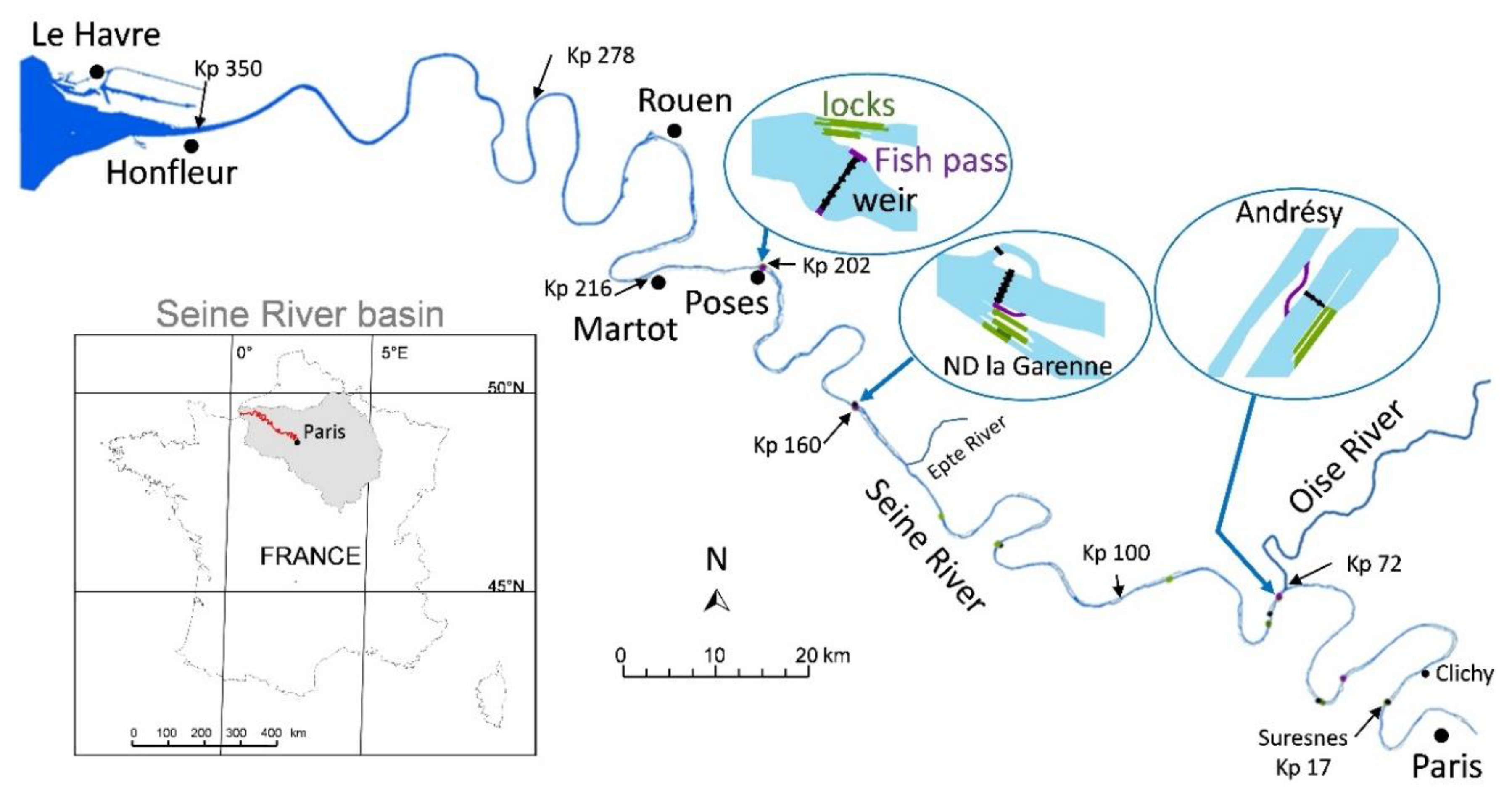
2.1. Context of the Study Area

The Seine River has a long history of human presence and impacts dating back to the Gallo-Roman era and coinciding with the development of the city of Paris and its activities [27]. The most critical period for the health of the river ecosystem started with the Industrial Revolution in the mid-nineteenth century in France, identified as a turning point with the beginning of the Anthropocene [28]. Deeply modified for navigation and harbor development, the Seine River has undergone various morphological alterations [29], been equipped with navigation weirs, and lost a great number of sandbars, intertidal areas, and islands. Used as a receptacle for liquid waste [28], the river suffered continuous degradation and pollution related to the increase in urban population and industrial activities from the beginning of the nineteenth century [27,30]. In 1889, sewage farms were built upstream and downstream of Paris, but never in a sufficient number to treat all Parisian sewers [30]. After the Second World War, the Achères wastewater treatment plant was established to treat waste from up to eight million people, releasing the treated effluent 70 km downstream of Paris [31]. For nearly five decades, water quality has improved by means of regulation, planning, and management efforts. Currently, the Seine River Basin (76,260 km2) represents 25–30% of French industrial activity, 50% of national river freight (1400 km of navigable waterways), and 23% of the French population for only 12% of the French territory [31]. The navigation weirs of the Seine River and its main tributaries currently include 23 fish passes.
Before human intervention, the Seine River hosted 11 diadromous and at least 22 freshwater fish species [32]. As in several other European rivers, the fish community has changed since the medieval period due to overfishing, pollution, habitat destruction, and the disruption of migration routes. This led to a dramatic decline in diadromous fishes at the end of the nineteenth century [33]. However, as a result of the establishment of non-native species, diversity has increased and now reaches 60 species [12]. The study area considered for the modeling of historical ecological connectivity is located on the lower Seine River from the sea to Paris and represents around 350 km. The estuary is 160 km long with tidal influence ending at the first obstacle from the sea: the Poses weir (Figure 1). Under the European Water Framework Directive (WFD), the Seine River has been classified as a heavily modified water body, and a recent evaluation (2019) showed contrasting situations from the sea to Paris. Its ecological status is medium to bad in the Seine estuary, medium in the fluvial reach (upstream of Poses) and good from the Oise confluence to Paris. Its physico-chemical status is bad on the whole estuary, medium and poor downstream of the Oise River, and good up to Paris. Mitigation actions are still required to reach “good potential” in 2027, particularly in the context of increasing human pressures on this basin. Notably, effective action is required to strengthen the recovery and sustainability of migratory fish populations in the Seine Basin and are part of numerous regional and national planning documents.

2.2. Selected Fish Species

Among the 11 diadromous fish species historically present in the Seine River Basin, we focused on Atlantic salmon (Salmo salar, L., 1758), allis shad (Alosa alosa, L., 1758), and sea lamprey (Petromyzon marinus, L., 1758), which exhibit contrasting migratory behavior and different patterns of decline. For these three species, which need to migrate upstream of the Seine estuary to find suitable spawning habitats, barriers across the main-stem Seine and its tributaries represent the most significant limiting factor for their current recovery.
Before our study period, a strong decline of Atlantic salmon populations in Northwestern Europe between the early Middle Ages (450–900) and early modern times (1600) was documented and attributed to improvements in watermill technology [14]. In the Seine River, salmon was labeled as a rare species as early as the beginning of the seventeenth century [34] due to overfishing and headwater stream modifications [35]. Today in France, allis shad is critically endangered, the sea lamprey is endangered (a status that has worsened since the last evaluation in 2010), and Atlantic salmon is nearly threatened [36] (Table 1).
All species are listed in the Bern Convention (Appendix V) and in the Habitats Directive of the European Union (Annexes II and V). Migration period(s), DO preferences, and swimming behavior were considered as relevant variables to characterize upstream spawning migration (Table 1).

2.3. Historical Data

We defined the main historical periods of physical and chemical changes in the Seine River on the basis of a review of existing literature and expert knowledge. Based on the available data, three periods were chosen as representative of major changes, and these were used for ecological connectivity modeling, namely the 1900s, 1970s, and 2010s.

2.3.1. Physical Features and Infrastructures

We georeferenced the historical maps to compare the river course and the location of physical features across the different periods. For 1900, 89 paper maps of the Seine River from Paris to Rouen were available thanks to the cartographer Raoul Vuillaume (1:10,000) and from Rouen to the sea thanks to the cartographers Cardin and Babin [41] and the Archives from the Grand Port Maritime de Rouen (GPMR). For 1970, we used the topographic maps of France (1:50,000) produced in 1950 by the National Institute of Geographic and Forest Information (IGN) (available online at https://remonterletemps.ign.fr) and 46 topographic maps (1: 10,000) centered on the Seine River from Paris to Rouen. These high-definition historical images were integrated into a georeferenced system (Lambert93, ESPG 2154) using a thin-plate spline transformation based on standard points (churches, bridges, buildings, crossroads, etc.) and a cubic sampling method that limits geometric distortions. For the current period, we used the National topographic database BD TOPO® 2.2 (IGN, http://www.ign.fr/) where water surfaces are available with two-dimensional (2D) precision from 1.5 to 2.5 m.
Among the physical barriers that could affect fish movements and migrations from the sea to Paris, we focused on weirs, locks, and hydropower plants. Gray literature provided knowledge of the general development of the Seine from Paris to the sea since the nineteenth century [42,43,44,45]. The location of weirs and locks, their creation date and modifications, and the evolution of waterfall height were recorded from ancient maps and national and departmental archives (Supplementary Table S1). In particular, the archives of the navigation service of the Seine River contained useful resources such as local maps, longitudinal profiles (with altitudes), detailed maps of weirs and locks, navigation-improvement planning, channel rectification, and island removal. In addition, we used navigation guides, online aerial photos dating back to the First World War (IGN), and online reports from the Bibliothèque Nationale de France (https://gallica.bnf.fr/). All this information was used to evaluate the potential impact of the physical changes on migrations of the three migratory species.
As fish ladders and passes were rarely indicated on historical maps, we consulted other written sources. Thanks to fishermen complaining about the decline of fish stocks and partly accusing navigation dams, the government’s awareness of this issue led to decrees and laws, starting with the Fishing Act in 1865. Ministerial circulars about fish passage characteristics, synthesis, and reports from several commissions and surveys about fish ladder effectiveness were used as the main sources to understand their changes. These archives were mainly available in the National Archives and the Archives from the Ministry of Public Works [46]. Knowledge of current fish pass construction is well-documented thanks to reports from the French Navigation Rivers service (VNF) and state services ensuring the regulatory supervision of their effectiveness.

2.3.2. Chemical Barriers

We chose dissolved oxygen (DO) as one of the most relevant factors of water quality affecting fish migration. The information was available for several periods based on different data sources. Monthly/quarterly measurements were available for 22 stations on the Seine River from Paris to Rouen between 1871 and 1938, recorded by the chemical department at the Montsouris Observatory [47,48]. The Water Agency of the Seine-Normandie Basin (created in 1964 to monitor the quality of aquatic systems) provided monthly measures of DO dating back to 1971 for 41 stations from Paris to Honfleur. The Seine navigation service provided monthly measures of DO for the period 1955–2015 from Poses (kp 202) to Honfleur (kp 350). These sources allowed us to create three spatiotemporal databases (kp of available stations × 12 months) of monthly average oxygen values (averaged across around 10-year periods) for each time period, namely 1892–1904, 1971–1980, and 2009–2017. We used linear interpolation to impute missing values using R 3.6.0 [49]. To obtain continuous values through the spatiotemporal table (kp × 12 months), we used the interp function from the Akima package (v0.6-2 [50]), which allows for the interpolation of values from irregularly spaced input data [51]. Isopleth graphs were then realized using the filled.contour function from the graphics package (v3.6.2; [52]). The full reproducible code is available in the Supplementary Materials.

2.3.3. Fish Historical Distribution

To document past species distribution from the end of the eighteenth century to the mid-twentieth century, we used the CHIPS database (Historical Catalog of Fishes of the Seine Basin), which compiles historical written sources [53]. Fish observations from the CHIPS database were updated, georeferenced, and used to map the historical distributions of the three studied species according to the locations of the most upstream presences on the hydrographic network [54]. To map the current distribution, we used recent observations from different sources, such as video-counting at fish passes since 2008 (Seinormigr, personal communication), anglers’ catches, and electrofishing surveys. Potential colonization distance estimates were calculated using current hydrographic distances (without considering potential channel modifications) from Honfleur to the most upstream presence recorded in around 1850.

2.4. Functional Connectivity Modeling

The current water extent (vector database 2018, IGN) was manually modified to delineate the water extent for the 1900s and 1970s using the corresponding georeferenced historical maps. The mean DO classes, calculated for each year, species migration period, and kilometer point (kp) were affected to the corresponding reaches using a spatial join procedure in ArcMap. The presence of infrastructures (weir, lock, fish pass, and hydroelectric power plants) was manually digitalized as vector patches using channel extent, historical maps, and available aerial photos. As fish ladders had small widths, their size was enlarged to reach a minimal patch size of 10 × 10 m, which was compatible with the raster modeling resolution of 5 m. All infrastructures were overlaid on 1-km-long reaches with DO classes to generate layers of physical and chemical barriers (hereafter called “resistance maps”) for each time and species migration period.
We then ran the least-cost calculation on each resistance map using Anaqualand 2.0 [55]. The minimal cumulative resistance (resistance × distance) or functional distance (functional kilometers: kmf) was calculated for each pixel of the map to obtain accessibility maps from the sea to Paris for each species/migration period and the three time periods. Resistance values were based on the assumption that resistance increases with energy cost, mortality, and predation risk associated with migration. Species-specific resistance values for weirs, locks, fish ladders, and passes were based on their permeability using expert classification according to the different periods studied. To evaluate the relative impact of chemical and physical barriers, we drew accessibility maps that included only physical barriers or maps that included both physical and chemical barriers.

3. Results

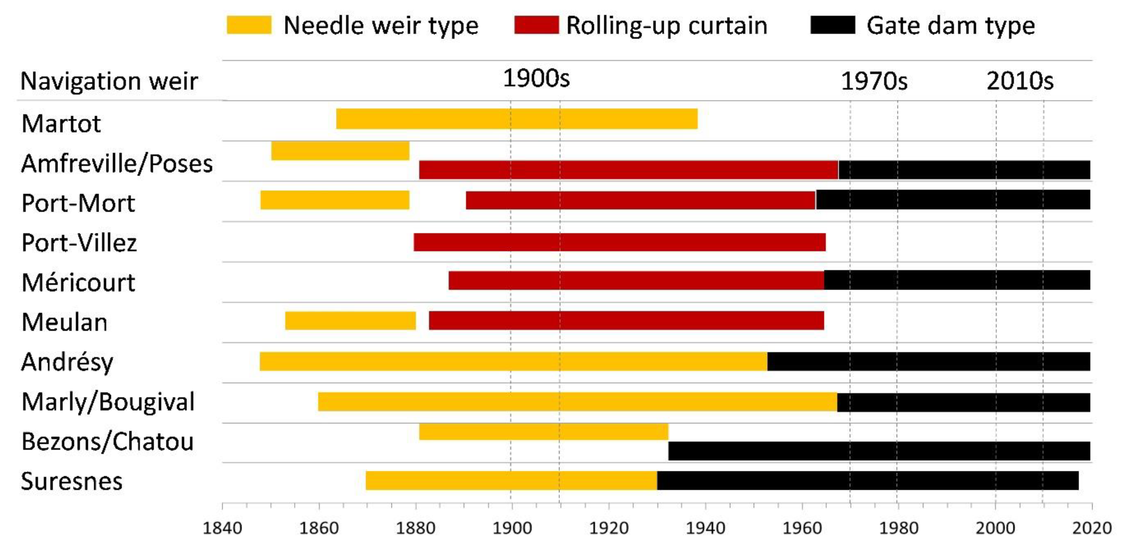
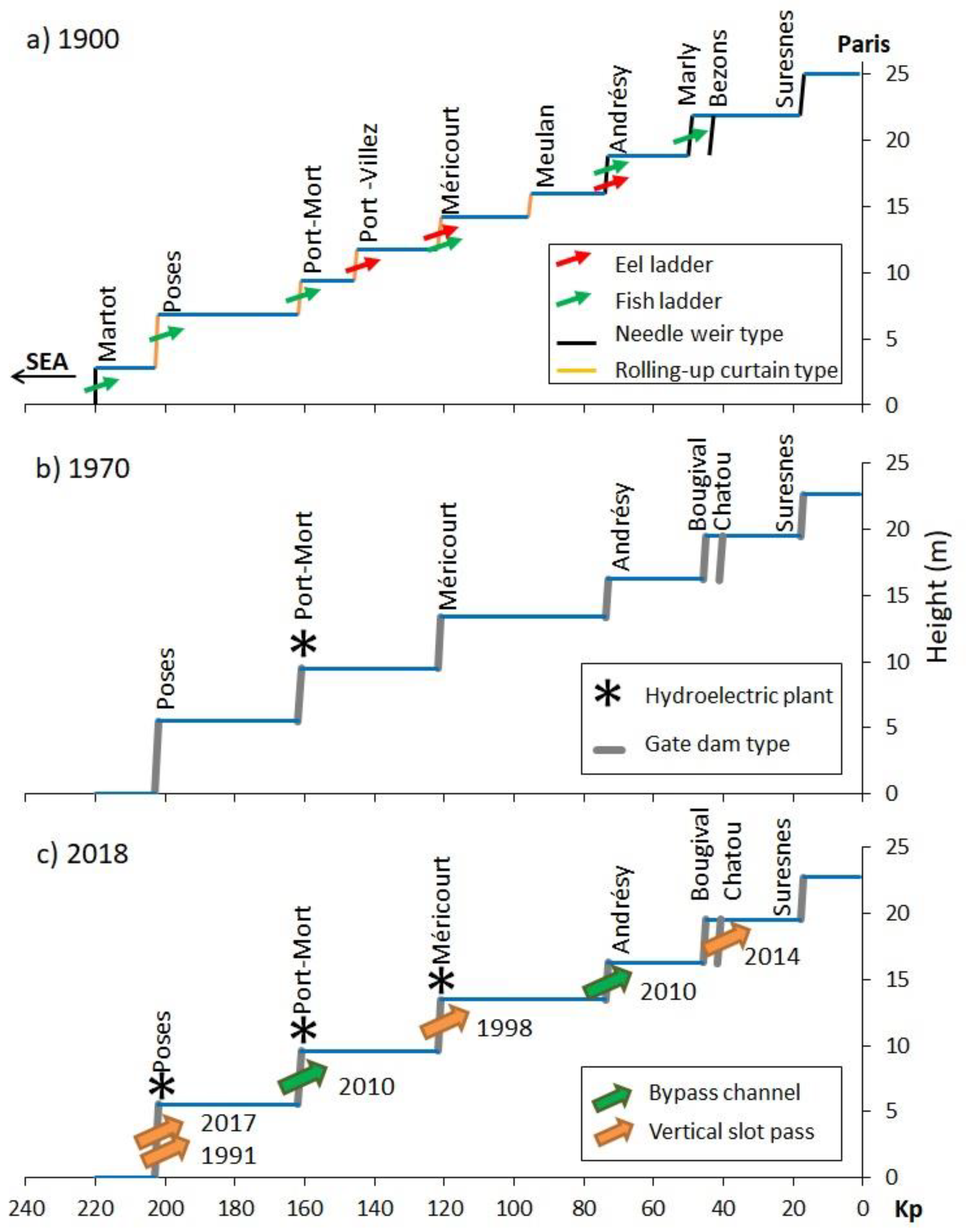
3.1. Historical Timeline of Weirs and Locks

When the Amfreville weir (kp 200) was built in 1850 just upstream of Poses, in the naturally tidal part of the Seine, it was the first physical barrier from the sea (Figure 1). To further increase the navigable areas without tidal effect, the Martot weir was built 16 km downstream in 1864 (waterfall height: 0.3 m at high tide −3 m at low tide) followed by the Poses weir in 1881 (no tide influence: 4.18 m [56]). Overall, between 1846 and 1886, the first set of 12 navigation weirs were built from the sea to Paris, of which 10 are on the main channel (Figure 2).
The natural waterline at a low flow in 1840 allowed for a 0.7-m draught; it was transformed in a succession of deep and low-current velocity basins with a draught reaching 3.2 m in 1900. Several technologies were used over time to build navigation weirs, which had increasing impacts on fish passage (Figure 2). The first weirs were composed of thin needles of wood or rolling-up curtain leaned against a solid frame that could be added or removed by hand to constrict river flow (Figure 2 and Figure 3a). Fish could pass through the openings of “needle” weirs during releases for navigation, floods, and winter. The former navigation weirs were renovated in the twentieth century or destroyed to reduce the number of forebays, especially since 1959 due to significant traffic development [57]. Gate dam types (Aubert’s, radial, slide gate, and automated systems of flap gates), composed of several gates moving around a horizontal or vertical axis, were built since 1930 (Figure 2). As a result of these technological advances, the number of navigation weirs decreased over time, whereas their waterfall height increased to address navigation needs, impeding more and more fish from passing through, except during extreme floods (Figure 3b). Parallel to this, the activity of narrow locks decreased due to vessel enlargement, leading to some disused open or closed locks. The adaptation of lock operations as means to improve fish passage has not been implemented on the Seine River.

3.2. History of Fish Passes

The history of fish passes actually began with the Fishing Act in 1865, which commanded the construction of fish ladders while compensating the dam owners. An evaluation of built fish ladders carried out in 1875 showed the lack of effectiveness of the two fish ladders built on the Seine River: Martot and Marly (Supplementary Table S2). In 1881, using information on the 54 fish ladders existing in France, navigation engineers from the Ponts et Chaussées (bridges and highways) tried to improve ladder efficiency. Main issues were (i) too high slopes, (ii) inadequate current velocities to swimming capacities (target species: mainly Atlantic salmon and shads), or (iii) unattractive locations. As a result, chief engineer Caméré designed several fish ladders from 1890 to 1903 on the Seine River (Supplementary Table S2). Three ladders were specifically designed for eels in the shape of ascending ramps. At this time, only six ladders occurred on the Seine River (Figure 3a) comparing to 100 ladders on the Loire River, and about 10 on the Rhone River). In 1897, a commission on agricultural and forestry improvements concluded that major economic problems would occur in the industrial and agricultural sectors if new fish ladders were prescribed (AN F14-13615). Despite this, decrees ordering French rivers to the fish ladder regime were enacted, especially in 1904 for the Seine River.
A report from the engineer Bachelier put forward a French Atlantic salmon ladder program at the Migratory Fish Commission in 1950 (AN-19920558-18). The scientific laboratory testing of ladder configurations to search for efficient fishways started with Denil’s fishway at the beginning of the twentieth century. This was followed by many tests of fishway configurations in different countries [58,59]. An increasing number of new fishways were designed in France (300) in the 1980s following a new decree (1969–1974) in which the construction of fish passages was the responsibility of the owner of the structure. The Fishing Law of 1984 reasserted the classification of watercourses and the obligation to equipped barriers. In 2006, the French law on water and aquatic environments (LEMA 2006-1772 law), which is the transposal of the European WFD, led, in 2013, to the classification of the Seine River as a watercourse in which it is important to ensure ecological connectivity for mobile organisms and the natural transport of sediments. Its implementation resulted in the acceleration of the renewal of fish passage construction, particularly those equipping the navigation weirs owned by the VNF in the Seine River Basin. Depending on land availability, new passes are of two types: vertical slot pass and bypass channel (Figure 3c).

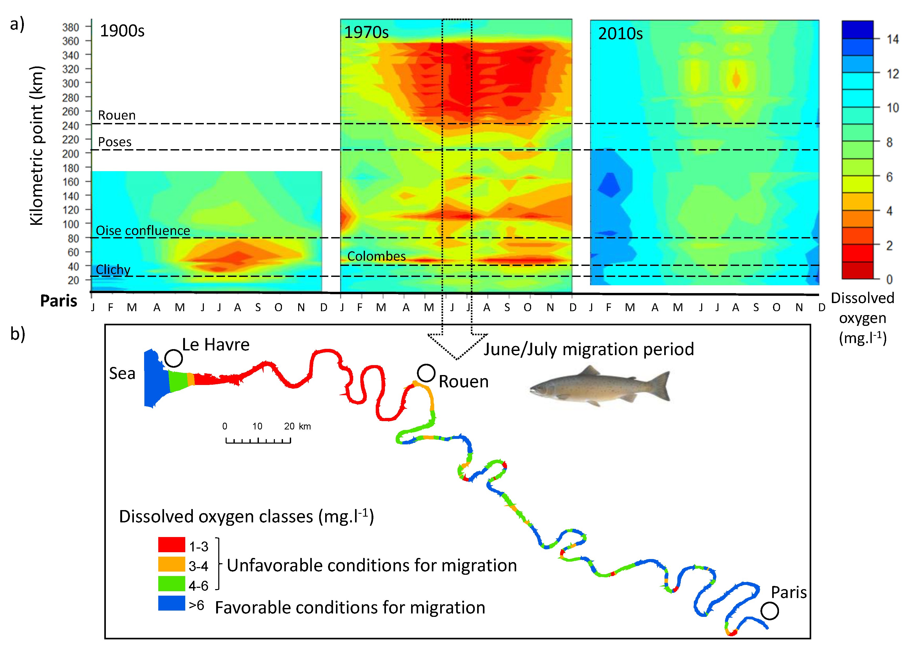
3.3. Dissolved Oxygen Evolution

Isopleth graph analysis showed strong intra-annual variations of DO from the sea to Paris in the three periods (Figure 4a). The longitudinal patterns appeared to contrast among the three periods and, overall, to be consistent with previous knowledge on the basin [46,60,61]. DO thresholds of 3, 4, and 6 mg·L−1 constitute chemical barriers for the sea lamprey, allis shad, and Atlantic salmon, respectively.
In the 1900s, from the Oise confluence to Clichy, unfavorable conditions were observed for the migration of Atlantic salmon, allis shad, and sea lamprey over five-to-seven months. In the 1970s, several hypoxic reaches appeared along the entire Seine River from March to December. A nearly year-long chemical barrier was observed in the estuary from the Seine Bay to Rouen with very low DO values and unfavorable migration conditions for Atlantic salmon in a critical part of its migration route (Figure 4b). Reaches from the Oise confluence to Colombes were impacted by increasing urbanization, diffuse waste, and untreated sewage during rainy events. In the 2010s, no hypoxic periods were observed irrespective of the season, except for a short period in August in the estuary that was not favorable for Atlantic salmon migration.

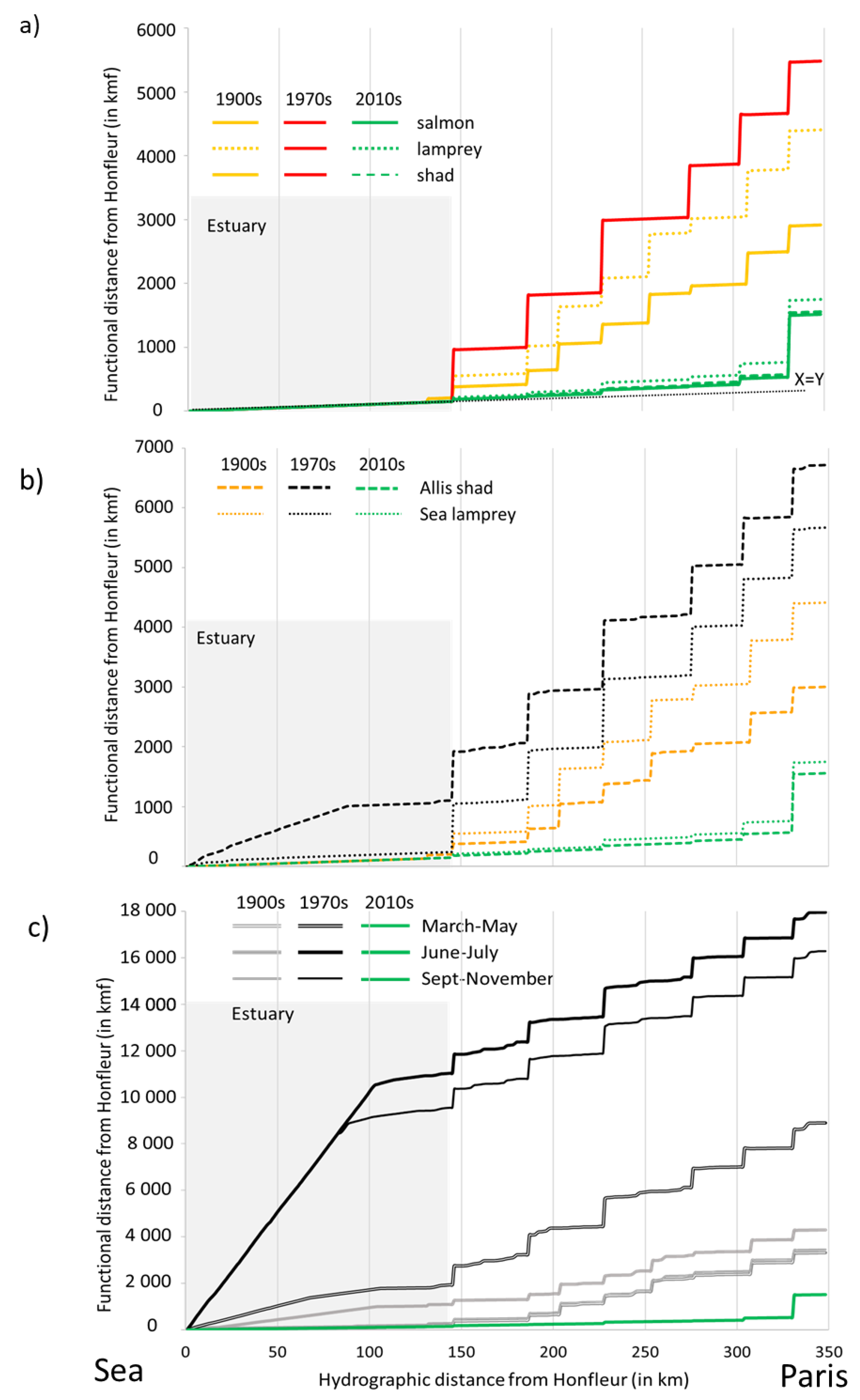
3.4. Accessibility: Comparison of Functional Distances

Based on historic and current knowledge of physical and chemical barriers, we assigned resistance values according to the potential increasing biological cost/risk associated with crossing the feature (Table 2). The detail of resistance values assignment is provided in Supplementary Material (Online Resource 2).
Accounting only for physical barriers, functional distances to reach Paris from the sea were higher in the 1970s and similar for the three species Figure 5a). In the 1900s, functional distances were lower for Atlantic salmon and allis shad but remained high for sea lamprey due to its lower capacity to cross needle-type weirs and fish ladders Figure 5a). In the 2010s, functional distances were lower due to the fish pass equipment of navigation weirs, but they increased drastically just downstream Paris due to the Suresnes impassable weir. The cumulative impacts of physical and chemical barriers on allis shad and sea lamprey accessibilities to Paris allowed us to examine their different migratory behaviors Figure 5b). In the 1900s, the functional distance increases from the sea to Paris for the two species resulted mainly from the presence of needle and rolling curtain weirs equipped or not with fish ladders. Accessibility for sea lamprey was lower than for allis shad due to its lower capacity to cross the weir and fish ladder (Table 2). Only slight cumulative effects of the chemical barriers were observed between some weirs, as DO values were mainly favorable during the migration period for these two species (March to June) (see Figure 3a). This trend intensified in the 1970s, as weirs became impassable with no fish passes and new anoxic zones cumulated, especially in the estuarine part, affecting allis shad migration. In the 2010s, no chemical barrier was considered (since oxygen was not limiting). Thus, the overall accessibility in this period was similar to the physical barrier-only scenario. Accessibilities were relatively similar for both species with the drastic impact of the Suresnes impassable weir that is downstream from Paris Figure 5b). For Atlantic salmon, we noticed interesting seasonal variations in accessibility in the 1900s and 1970s Figure 5c). The functional distances in the 1900s for the spring and autumn migrations were lower than for the summer migration, indicating better accessibilities for these two seasons. The longitudinal contribution of the scenario with physical barriers on overall functional distances (scenario with physical and chemical barriers) indicated that this stressor dominated for spring migration and its impact decreased in favor of chemical barriers for other migration period (Supplementary Figure S1). In the 1970s, the clear cumulative effects of chemical and physical barriers were observed on accessibilities. In the estuary, functional distances sharply increased due to long-distance chemical barriers, and then a succession of high increases (physical barriers) were cumulated with lower increases (chemical barriers). In this period, summer was still the more unfavorable season for migration with nearly five times lower accessibility than in the 1900s due to hypoxic conditions for long distances along the entire river stretch. Spring was the more propitious season for migration, although conditions were degraded compared with 1900. In the 2010s and currently, migration conditions for this species have been improved compared to the 1900s as the result of fish passes building and decreasing chemical barriers regardless of the season.

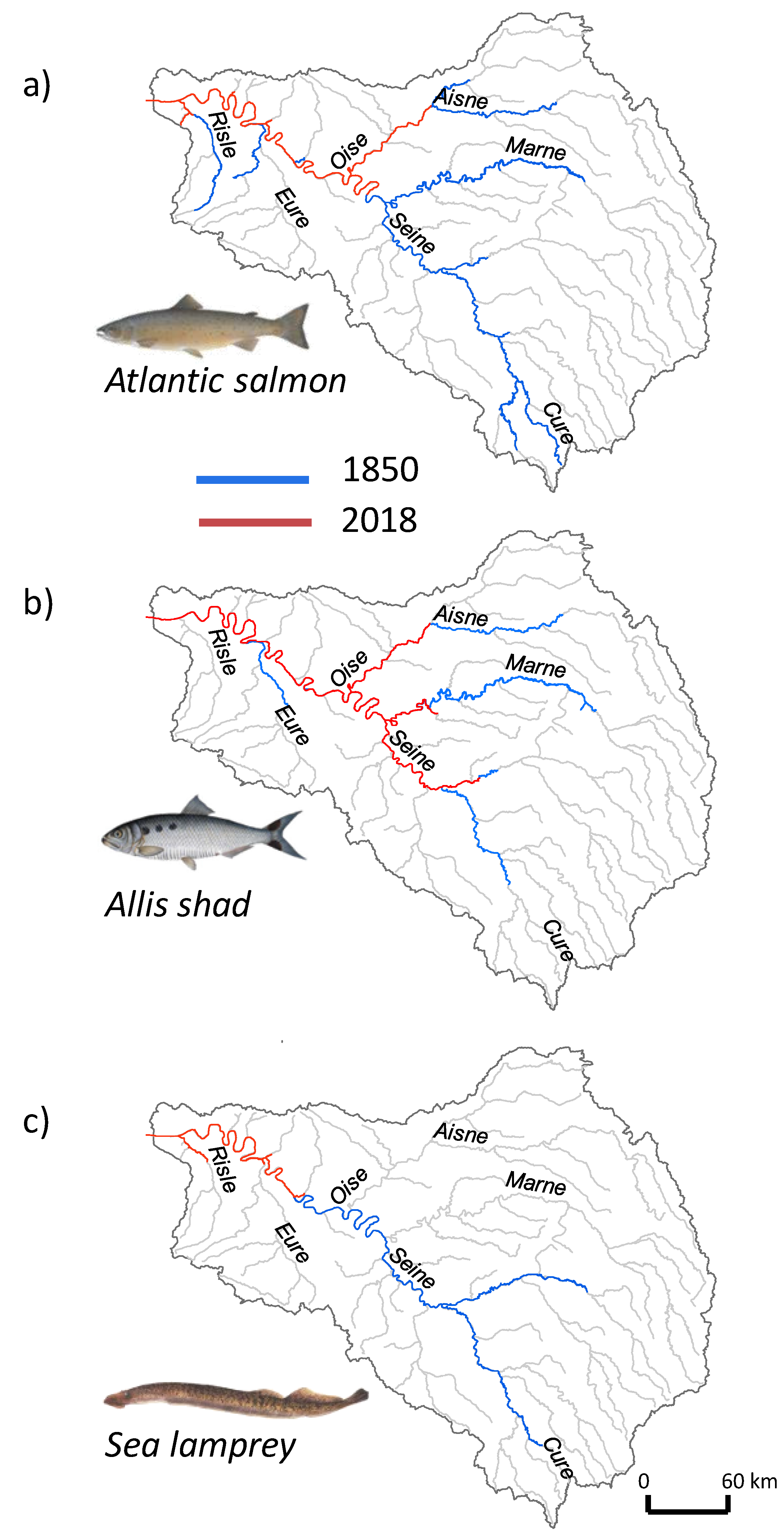
3.5. Historical Fish Distribution

In the 1850s, Atlantic salmon was known to reach headwaters of the basin to spawn up to 684 km from the sea on the Cure River, but occasional observations were also recorded on the Marne (610 km) and the Aisne (528 km) Rivers in the northern part of the basin (Figure 6a).
The second half of the nineteenth century showed the continued collapse of Atlantic salmon, then restricted to only some tributaries, due to multiple barriers (weirs and locks, dams in headwater catchments, and pollution) to fish spawning migration [39]. In the 1970s, this species was regarded as extirpated [12], despite individuals caught accidentally in the lower part of the estuary (kp 278) [62]. In 2008, 260 individuals of Atlantic salmon were observed passing at the video-counting station of Poses [37], but there was no indication of their distribution upstream. The known current distribution extends up to 350–400 km to the Oise River (Figure 6a) as indicated by records in a new video-counting station at the confluence of the Aisne River (2018). Allis shad was one of the most widely spread migratory species in the Seine Basin in the first part of the nineteenth century [40]. The most upstream reports of its presence were 624 km away from the sea on the Marne River, 538 km on the Aisne River, and 551 km on the Yonne River (Figure 6b). Its decline started with the first navigation weirs built between 1850 and 1881. In 1920, only rare and isolated individuals were still observed downstream of Poses weirs [41]. Allis shad was considered to be extinct in the 1960s [42]. More broadly, the decline of shads has been related to the cumulative effect of habitat degradation and physical and chemical barriers preventing individuals from reaching spawning habitats upstream of estuaries [43]. In the Seine River, recolonizing individuals of allis shad have been observed since 2004, with clear evidence of reproduction [40], and, today, they have been observed up to 400–454 km in some tributaries (Figure 6b). In the 1850s, sea lamprey had two attested colonization fronts in the Cure River Basin (614 km) and the Aube River (586 km), but we can speculate that it had a wider distribution (Figure 6c). The freshwater distribution of the sea lamprey decreased over the second half of the twentieth century, and the species was considered extinct in the 1970s [42]. The current distribution of sea lamprey extends up to 230 km (Figure 6c).

4. Discussion

4.1. Reconstructing the Tide of History

By combining historical data sources, engineering sciences, and fish ecology, this interdisciplinary study offers a better understanding of how multiple stressors act on diadromous fish species in the Seine River over a long-term perspective. The use of historical sources and current data on physical and chemical barriers made it possible to reconstruct the history of ecological connectivity for fish from the sea to Paris over the past 170 years. Precise knowledge of the chronological timeline of the two stressors provided a sort of spatiotemporal puzzle by using the history of each piece acting positively or negatively on ecological connectivity. Such socio-ecological hydrosystems are complex adaptative systems that have unexpected emergent properties that cannot be predicted by knowing the individual constituents alone [63]. While global trends in the spatial distribution of physical and chemical stressors have been documented in the Seine River [64], we have quantified their cumulative effects on fish migration over time. Both stressors have been documented in other large river systems in a long-term perspective, but they have often been considered separately [16,65,66,67].
The temporal trajectories of species decline and recolonization, visible over the spatial extent of the species distribution over time, have been related to the ecological connectivity changes. The migratory fish species in the Seine River Basin have generally followed the common pattern of declines observed for North Atlantic diadromous species, namely a sharp population decline between the end of the eighteenth and the beginning of the twentieth century [68]. The distribution of the three studied species in the 1850s extended in the Seine River and main tributaries up to 500–700 km upstream from the sea, although this situation could have already been the result of early declines since the Middle Ages [14]. During the 1850–1881 period, the most downstream Martot and Amfreville/Poses weirs (cumulative height of 6.8 m over just 20 km) are known to have had a major impact by reducing the accessibility of a wide part of the basin [69]. The construction of the first 12 navigation weirs (1846–1869), the delay of most fish ladder construction (1880–1903), and their poor effectiveness led to the collapse of Atlantic salmon stocks in the 1900s and to the extirpation of allis shad in the 1920s [33]. Because of the increasing impact of physical barriers, most migratory species also became extinct at this period in the Lambro River (Milan), the Spree River (Berlin) [70], and the Scheldt River [71]. In the 1900s, we highlighted that chemical barriers were already present in the fluvial and estuarine reaches of the Seine River. The deficit in DO around 70–150 km downstream of the sewer system discharge in Clichy was compensated for by flows from the Oise confluence, which played a crucial role in reoxygenating the Seine [60]. The seasonal differences in accessibilities to Paris estimated in the 1900s could have particularly affected young salmons (one winter at sea (1SW)), since they migrate from February to September, compared with the oldest salmons (two winters at sea (2SW)), for which migration started in autumn [46]. However, historical sources have suggested that the Seine Atlantic salmon stock was composed mainly of large individuals (2SW). Parallel to this, historical Atlantic salmon spawning grounds on the Cure River (see its location Figure 6) became unreachable in 1858 with the construction of the Settons Dam (19 m high) [72].
The highest cumulative disruption of ecological connectivity was observed in the 1970s as a consequence of the post-war boom with a period of strong industrialization. The long-distance chemical barrier in the Seine estuary (and many more along the river) concurred with the renovation and heightening of weirs with no fish passes, thereby explaining this result. The very low level of DO in the Seine estuary was principally related to inputs from its upstream watershed [73]. In the 1970s, more than half of the wastewater produced by Paris was discharged into the Seine without treatment. Tributaries such as the Oise River were no longer playing the role of re-oxygenating the Seine River. The alteration of water quality was such that the extinction of species was considered irreversible and the idea of maintaining and rebuilding fish passes was abandoned. Integrating all these issues, the highest functional distances from the sea to Paris were observed at this period, especially for Atlantic salmon in summer and autumn migrations, as well as, to a lesser extent, for allis shad and sea lamprey. Whereas the first two species were still considered as extirpated from the Seine River Basin, the sea lamprey disappeared in the 1970s.
The current ecological connectivity has improved at a highest level than in the 1900s for the three species. In the 2010s, favorable oxygenating conditions were observed for the three species, and all migration periods in parallel to the construction of a new generation of efficient fish passes. Our results confirm the recent trend of no further long anoxic periods in the Seine River and its estuary since 2007 [61], a consequence of the progress made in the 1990s in terms of wastewater treatment following the Water Law (1964). At the same time, the Fishing Law of 1984 revived the construction of fish passages. The “return to sources contracts,” which proposed the first management plans for migratory fish, was established, and several migratory fish associations in the French river basins were created. In this context, a study defined the strategy for the return of Atlantic salmon to the Seine River at the beginning of the 1990s [74], and the first fish pass of Poses was built in 1991. The EU WFD and the National Plan for ecological continuity (2010) just reinforced this turning point, and the renewal of fish passage construction was deployed during the recent renovation of navigation weirs. The recent improvement in migration route accessibility has very recently led to the spontaneous recolonization of the Seine River by individuals of migratory fish species. Since 2004, some individuals of allis shad have been observed upstream of Paris on the Marne and Seine Rivers. Their surprising presence upstream of an navigation weir with no fish pass was probably related to high flows and/or the ability of this species to use locks, as shown with radio-tracking operations in the Rhone River [75]. On the Oise River, where all the navigation weirs are equipped with fish passes, the most upstream observations of Atlantic salmon and allis shad were reported in 2018 by video-counting at the Aisne confluence (Figure 6). To our knowledge, the distribution of sea lamprey remained restricted up to the Epte River, where the local angling association observed reproduction events (see Figure 1 and Figure 6). However, the observation of one individual on the lower Oise River in the early 2000s (Holl, personal communication) could suggest further potential for settlement.
The global historical analysis highlighted that, in addition to structural aspects, there is social aspect in explaining the changes in ecological connectivity through time. Such river–society interactions are spatially and temporally complex and can be addressed by an interdisciplinary collaboration between hydrobiologists and environmental historians [60]. Our study showed the example of a river long affected by humans, such as the Moselle [76] or the Danube [67], as a very complex historical object. We emphasized the interactions of human impacts on functional connectivity with historic conflicts of use between stakeholders regarding the attempt to restore the free movement of migratory fish. The social consensus, driven by industrial interests for long periods [76] and the perception of rivers as not healthy, has, for instance, prevented the implementation of efficient fish passage management strategies. Beyond the Seine, lessons from our historical approach to ecological connectivity can be applied to other riverine anthroposystems affected by physical and chemical barriers. In particular, since many large river systems in Northwestern Europe have been affected by common nineteenth and twentieth century stressors such as river regulation and dam construction, pollution, and overfishing [77], our approach can be useful for a better understanding of the functional connectivity of these systems.

4.2. The Modeling Approach

The least-cost modeling approach and the functional distance calculation that spatially integrates the cumulative effect of physical and chemical barriers provide a fish-based longitudinal indicator of the habitat accessibility for large rivers. This approach was useful to evaluate the relative contribution of physical and chemical barriers in habitat accessibility and to help disentangle the complexity of multiple-stressor situations. For instance, the comparison of scenarios with and without chemical barriers indicated a longitudinal contribution of chemical stress in the overall accessibility to upper Seine. The spatially explicit approach was also beneficial to visually observe the impact of the two types of barriers along the river course and to compare the access to a specific kilometric point according to the time period for the different species. Maps produced using our approach represent a valuable medium for communicating to managers the consequences of different management scenarios and, subsequently, guiding decision-making.
The combination of historical and current sources (maps, reports, questionnaires, postcards, pictures, etc.) was relevant in order to map and precisely locate navigation weirs, locks, and fish ladders/passes, thereby allowing for longitudinal cumulative calculations of accessibility. The use of functional kilometers compared with hydrographic kilometers was intuitive and made it possible to understand the relative cost of crossing physical and chemical barriers. The comparison between historical periods for behaviorally distinct species highlighted the complex impacts of physical and chemical barriers on their migration capacities and their dispersion to upstream habitats.
The resolution of 1 km we used to spatialize DO values from the sea to Paris was a compromise, as the original data had different spatial resolutions depending on the time period. We imputed missing data for the 1900s with the “best hypothesis and knowledge of historians.” Despite this potential bias, we obtained consistent longitudinal DO profiles, in particular for the long-term summer hypoxia that is well documented [31]. Though historical trends in navigation weir settlement are relatively known [31], information such as the precise date of construction, renovation, or removal was difficult to recover or was barely available. Reports from navigation engineers were particularly valuable to document the technological evolution of weirs and fish ladders and to understand the evolution of passability for fish.
While this approach has demonstrated its usefulness in comparing scenarios [78] and emphasizing the relative importance of chemical and physical barriers on connectivity, there is still room for improvement, including refining the hypothesis underlying the choice of resistance values [79]. One perspective is to integrate the individual resistance for each weir based on its height and for each fish pass in the 2010s based on their functioning and expert evaluation. The movement of individuals using acoustic telemetry data could also provide invaluable knowledge about movement behavior, as shown downstream of Poses for estuarine species [80], which could help the calibration of resistance values. Future experiments using acoustic telemetry would provide a more realistic range of resistance values for each recent fish pass (see, e.g., the Consacre project, www.consacre.fr). Another avenue of research is to integrate the flood tide in connectivity modeling, as this process can facilitate species migration upstream from the estuary. In addition, water temperature during migration could be integrated into future scenarios as a potential future chemical barrier, since this environmental parameter, particularly in summer, impacts DO values and could lead to mortality, as shown in the Allier River [81].

4.3. Management Implications and Perspectives

Adaptative management for highly anthropized hydrosystems could benefit from the insights gained from past experience and the knowledge of potential long-term legacies [82]. These elements are fundamental for developing strategies to envisage the mitigation of interacting stressors [83]. Understanding the structural and social interacting causes of the past decline and recolonization processes of fish species guides future management and helps prioritize actions along the Seine River. We have highlighted the dominant role of chemical quality over other physical features as the consequence of historical management actions undertaken from the mid-nineteenth century onwards. The very limited evolution of the situation and regulation of fish ladders and passes since the end of the nineteenth century has resulted from long-run conflicts of interest between fishermen, industry, and agriculture, as well as from the complex role of the Ministry of Public Works in the application of decrees and laws [84]. A 1902 review by Violette with contemporary resonance underlined the prejudice relating to the higher degree of public utility of installing a hydro-electric plant compared with that of the right to fish [85]. Actions in favor of fish passage finally became more easily defensible with the implementation of successive laws —Water Law in 1964 and Fishing Law in 1984— and European regulations in the twentieth century and early twenty-first century. The context of improvement of water quality in the 1980s contributed to opening mindsets to environmental measures. Today, the observation of individuals of Atlantic salmon and allis shad on the Oise River is an encouraging sign, showing the effectiveness of ecological connectivity restoration methods, such as equipping all navigation weirs with a fish pass. In this context, it is crucial to develop complementary tools to measure ecological connectivity, e.g., video-counting or biotelemetry data, as well as the participation of anglers by communicating their catches.
In order to support the raising recovery of migratory fish, there are several alternatives as management actions. First, our study confirmed the importance of maintaining good chemical water quality throughout the year on the Seine River, its estuary, and its main tributaries. In particular, avoiding hypoxic events in the tidal freshwater part of the estuary is important to allow for upstream migration opportunities for anadromous spawners, as also pointed out in the Scheldt study [71]. Improvements in wastewater networks and their management have led to a considerable reduction in discharges during rainy weather, which decreases the risk of seasonal fish mortality. This is crucial in large river systems that are structurally sensitive to wastewater inputs due to low flows or extreme events (violent storms or industrial accidents), which can lead to rapid decreases in the oxygen level below fish survival values [86]. Second, maintaining (and increasing) the effectiveness of existing fish passages is also an important driver and a condition for sustainable restoration measures [87]. Third, the preservation or restoration of ecological connectivity in tributaries close to the estuarine area is another way to improve the maintenance of migratory populations. Further research is needed to identify the locations of potential suitable spawning habitats in the basin (as potential targets of migration). Though the conditions for upstream migration have generally improved over the last few decades, the potential local deterioration or destruction of spawning habitats needs to be evaluated because it strongly limits the possibilities for restoration.
An important issue for the sustainable management of river basins in Europe is to integrate future scenarios of global change. Climate change will have significant effects on the Seine River Basin, including modifying its flood regime [88,89]. This will, in turn, affect the future ecological connectivity for species that are now recolonizing the Seine River Basin. Therefore, modeling these effects is of great importance to guide future management actions. Projections of species distribution over Europe and scenarios of temperature evolution in the Seine River Basin suggest the potential favorability of the basin for shads but a decreasing favorability for salmonids [37]. In this context, prioritizing efforts to restore ecological connectivity could also consist of focusing on cooler tributaries and upstream parts of the Seine, Oise, and Marne Rivers.

Supplementary Materials

The following are available online at https://www.mdpi.com/2073-4441/12/5/1352/s1, Online resource: Resistance values assignment, Figure S1: Longitudinal changes in the contribution of the scenario with physical barriers on the overall functional distances calculated for Atlantic salmon in the 1900s according to the migration periods, Table S1: On-site and online historical and current sources used to document the studied periods, Table S2: Fish ladders built on the Seine River at the end of the nineteenth century. Specific ladders for eel passage are indicated in italic.

Author Contributions

Conceptualization and methodology, C.L.P., L.L., J.B., and E.T.; archives investigation and resources, L.L., E.C., J.B., and M.-L.M.; formal analysis, E.C., C.L.P., and M.-L.M.; writing—original draft preparation, C.L.P. and E.C.; writing—review and editing, C.L.P., L.L., J.B., E.T., and M.-L.M. All authors have read and agreed on the published version of the manuscript.

Funding

This research was funded by the Water Agency “Agence de l’Eau Seine-Normandie” and the Regions Normandie and Ile-de-France.

Acknowledgments

This study was carried out as part of the CONSACRE project, managed by the GIP Seine-Aval and INRAE-HYCAR and supported by the state-interregional planning contract “Vallée de la Seine” (2015–2020) and the ZA Seine (LTSER, Long-Term Ecosystem Research in Europe). We thank Nicolas Bacq, Eric L’Ebrellec, and Cédric Fisson (GIP Seine-Aval) for providing historical documents and georeferenced data of the Seine estuary. We thank Amandine Zahm (INRAE) for running part of the tested scenarios and Olivier Delaigue (INRAE) for his help in writing and running R scripts.

Conflicts of Interest

The authors declare no conflict of interest.

References

  1. Thorp, J.H.; Thoms, M.C.; Delong, M.D. The riverine ecosystem synthesis: Biocomplexity in river networks across space and time. River Res. Appl. 2006, 22, 123–147. [Google Scholar] [CrossRef]
  2. WWF. Living Planet Report-2018: Aiming Higher; Grooten, M., Almond, R.E.A., Eds.; WWF International: Gland, Switzerland, 2018; 148p. [Google Scholar]
  3. Dudgeon, D.; Arthington, A.H.; Gessner, M.O.; Kawabata, Z.-I.; Knowler, D.J.; Lévêque, C.; Naiman, R.J.; Prieur-Richard, A.-H.; Soto, D.; Stiassny, M.L.J.; et al. Freshwater biodiversity: Importance, threats, status and conservation challenges. Biol. Rev. 2006, 81, 163–182. [Google Scholar] [CrossRef] [PubMed]
  4. Dynesius, M.; Nilsson, C. Fragmentation and flow regulation of river systems in the northern third of the world. Science 1994, 266, 753–762. [Google Scholar] [CrossRef] [PubMed]
  5. Malaj, E.; Von der Ohe, P.C.; Grote, M.; Kühne, R.; Mondy, C.P.; Usseglio-Polatera, P.; Brack, W.; Schäfer, R.B. Organic chemicals jeopardize the health of freshwater ecosystems on the continental scale. Proc. Natl. Acad. Sci. USA 2014, 111, 9549–9554. [Google Scholar] [CrossRef] [Green Version]
  6. Fuller, M.R.; Doyle, M.W.; Strayer, D.L. Causes and consequences of habitat fragmentation in river networks. Ann. N. Y. Acad. Sci. 2015, 1355, 31–51. [Google Scholar] [CrossRef]
  7. Vörösmarty, C.J.; McIntyre, P.B.; Gessner, M.O.; Dudgeon, D.; Prusevich, A.; Green, P.; Glidden, S.; Bunn, S.E.; Sullivan, C.A.; Liermann, C.R. Global threats to human water security and river biodiversity. Nature 2010, 467, 555. [Google Scholar] [CrossRef]
  8. Duncan, J.R.; Lockwood, J.L. Extinction in a field of bullets: A search for causes in the decline of the world’s freshwater fishes. Biol. Conserv. 2001, 102, 97–105. [Google Scholar] [CrossRef]
  9. Fullerton, A.H.; Burnett, K.M.; Steel, E.A.; Flitcroft, R.L.; Pess, G.R.; Feist, B.E.; Torgersen, C.E.; Miller, D.J.; Sanderson, B.L. Hydrological connectivity for riverine fish: Measurement challenges and research opportunities. Freshw. Biol. 2010, 55, 2215–2237. [Google Scholar] [CrossRef] [Green Version]
  10. Pringle, C.M. Hydrologic connectivity and the management of biological reserves: A global perspective. Ecol. Appl. 2001, 11, 981–998. [Google Scholar] [CrossRef]
  11. Falke, J.A.; Dunham, J.B.; Jordan, C.E.; McNyset, K.M.; Reeves, G.H. Spatial ecological processes and local factors predict the distribution and abundance of spawning by Steelhead (Oncorhynchus mykiss) across a complex riverscape. PLoS ONE 2013, 8, e79232. [Google Scholar] [CrossRef]
  12. Belliard, J.; Beslagic, S.; Delaigue, O.; Tales, E. Reconstructing long-term trajectories of fish assemblages using historical data: The Seine River basin (France) during the last two centuries. Environ. Sci. Pollut. Res. 2018, 25, 23430–23450. [Google Scholar] [CrossRef] [PubMed]
  13. Haidvogl, G.; Hoffmann, R.; Pont, D. Historical ecology of riverine fish in Europe. Aquat. Sci. 2015, 77, 315–324. [Google Scholar] [CrossRef] [PubMed] [Green Version]
  14. Lenders, H.; Chamuleau, T.; Hendriks, A.; Lauwerier, R.; Leuven, R.; Verberk, W. Historical rise of waterpower initiated the collapse of salmon stocks. Sci. Rep. 2016, 6, 29269. [Google Scholar] [CrossRef] [PubMed] [Green Version]
  15. Lobón-Cerviá, J.; Elvira, B.; Rincón, P. Historical Changes in the Fish Fauna of the River Duero Basin. In Historical Change of Large Alluvial Rivers; Western Europe; Petts, G.E., Möller, H., Roux, A.L., Eds.; John Wiley and Sons: Chichester, UK, 1989; pp. 221–232. [Google Scholar]
  16. Segurado, P.; Branco, P.; Avelar, A.P.; Ferreira, M.T. Historical changes in the functional connectivity of rivers based on spatial network analysis and the past occurrences of diadromous species in Portugal. Aquat. Sci. 2015, 77, 427–440. [Google Scholar] [CrossRef]
  17. Van Puijenbroek, P.J.T.M.; Buijse, A.D.; Kraak, M.H.S.; Verdonschot, P.F.M. Species and river specific effects of river fragmentation on European anadromous fish species. River Res. Appl. 2019, 35, 68–77. [Google Scholar] [CrossRef]
  18. Tétard, S.; Feunteun, E.; Bultel, E.; Gadais, R.; Bégout, M.-L.; Trancart, T.; Lasne, E. Poor oxic conditions in a large estuary reduce connectivity from marine to freshwater habitats of a diadromous fish. Estuar. Coast. Shelf Sci. 2016, 169, 216–226. [Google Scholar] [CrossRef] [Green Version]
  19. Maes, J.; Stevens, M.; Breine, J. Poor water quality constrains the distribution and movements of twaite shad Alosa fallax fallax (Lacépède, 1803) in the watershed of river Scheldt. In Fish and Diadromy in Europe (Ecology, Management, Conservation); Dufour, S., Prévost, E., Rochard, E., Williot, P., Eds.; Developments in Hydrobiology; Springer: Dordrecht, The Netherlands, 2008; Volume 200, pp. 129–143. [Google Scholar]
  20. McDowall, R.M. Diadromy in Fishes: Migrations between Freshwater and Marine Environments; Croom Helm: London, UK, 1988; 250p. [Google Scholar]
  21. Dufour, S.; Prévost, E.; Rochard, E.; Williot, P. Fish and Diadromy in Europe (Ecology, Management, Conservation); Developments in Hydrobiology; Springer: Dordrecht, The Netherlands, 2008; Volume 200, 186p. [Google Scholar]
  22. Cote, D.; Kehler, D.; Bourne, C.; Wiersma, Y. A new measure of longitudinal connectivity for stream networks. Landsc. Ecol. 2009, 24, 101–113. [Google Scholar] [CrossRef] [Green Version]
  23. Adriaensen, F.; Chardon, J.P.; De Blust, G.; Swinnen, E.; Villalba, S.; Gulinck, H.; Matthysen, E. The application of ‘least-cost’ modelling as a functional landscape model. Landsc. Urban Plan. 2003, 64, 233–247. [Google Scholar] [CrossRef]
  24. Foubert, A.; Le Pichon, C.; Mingelbier, M.; Farrell, J.M.; Morin, J.; Lecomte, F. Modeling the effective spawning and nursery habitats of northern pike within a large spatiotemporally variable river landscape (St. Lawrence River, Canada). Limnol. Oceanogr. 2019, 64, 803–819. [Google Scholar] [CrossRef]
  25. Caldwell, I.; Gergel, S. Thresholds in seascape connectivity: Influence of mobility, habitat distribution, and current strength on fish movement. Landsc. Ecol. 2013, 28, 1937–1948. [Google Scholar] [CrossRef]
  26. Shaffer, H.B.; Fisher, R.N.; Davidson, C. The role of natural history collections in documenting species declines. Trends Ecol. Evol. 1998, 13, 27–30. [Google Scholar] [CrossRef]
  27. Guillerme, A. Le testament de la Seine/The legacy of the Seine. Géocarrefour 1990, 65, 240–250. [Google Scholar] [CrossRef]
  28. Meybeck, M.; Lestel, L.; Briand, C. La Seine sous Surveillance: Les Analyses des Impacts de L’agglomération Parisienne par L’observatoire de Montsouris de 1876 à 1937. In Les Rivières Urbaines et Leur Pollution; Lestel, L., Carré, C., Eds.; Collection Indisciplines, Editions Quae: Versailles, France, 2017; pp. 32–43. [Google Scholar]
  29. Lafite, R.; Romaña, L.-A. A man-altered macrotidal estuary: The Seine estuary (France): Introduction to the special issue. Estuaries Coasts 2001, 24, 939. [Google Scholar] [CrossRef]
  30. Barles, S. Urban metabolism and river systems: An historical perspective–Paris and the Seine, 1790–1970. Hydrol. Earth Syst. Sci. 2007, 4, 1845–1878. [Google Scholar] [CrossRef]
  31. Meybeck, M.; Lestel, L.; Carré, C.; Bouleau, G.; Garnier, J.; Mouchel, J.M. Trajectories of river chemical quality issues over the Longue Durée: The Seine River (1900s–2010). Environ. Sci. Pollut. Res. 2018, 25, 23468–23484. [Google Scholar] [CrossRef] [PubMed]
  32. Belliard, J.; Boet, P.; Allardi, J. Évolution à long terme du peuplement piscicole du bassin de la Seine. Bull. Fr. Pêche Piscic. 1995, 83–91. [Google Scholar] [CrossRef] [Green Version]
  33. Belliard, J.; Beslagic, S.; Tales, E. Changes in Fish Communities of the Seine Basin over a Long-Term Perspective. In The Seine River Basin; Flipo, N., Labadie, P., Lestel, L., Eds.; Handbook of Environmental Chemistry; Springer: Cham, Switzerland, 2020. [Google Scholar]
  34. Cavailler, P. Le fief de la Mothe ou maîtrise de l’eau de Corbeil au début du XVIIe siècle. In Paris et Ile-de-France, Mémoires, t. 45, La Seine et son Histoire en Ile-de-France; Fédération des sociétés historiques et archéologiques de Paris et Ile-de-France: Paris, France, 1994; pp. 169–192. [Google Scholar]
  35. Benoit, P.; Loridant, F.; Matteoni, O. Pêche et Pisciculture en eau douce: La Rivière et L’étang au Moyen Age. In Actes des 1es Rencontres Internationales de Liessies (conference proceedings); Conseil général du Nord: Lille, France, 2004; pp. 4–5. [Google Scholar]
  36. UICN; MNHN; AFB. Liste Rouge des Espèces Menacées en France, les Poissons D’eau Douce de France Métropolitaine; UICN: Montreuil, France, 2019; 16p. [Google Scholar]
  37. Rochard, E.; Pellegrini, P.; Marchal, J.; Béguer, M.; Ombredane, D.; Lassalle, G.; Menvielle, E.; Baglinière, J. Identification of diadromous fish species on which to focus river restoration: An example using an eco-anthropological approach (the Seine basin, France). In Proceedings of the Challenges for Diadromous Fishes in a Dynamic Global Environment, Halifax, NS, Canada, 18–21 June 2007; pp. 691–711. [Google Scholar]
  38. Belliard, J.; Marchal, J.; Ditche, J.-M.; Tales, E.; Sabatié, R.; Baglinière, J.-L. Return of adult anadromous allis shad (Alosa alosa L.) in the river Seine, France: A sign of river recovery? River Res. Appl. 2009, 25, 788–794. [Google Scholar] [CrossRef]
  39. Baudoin, J.; Burgun, V.; Chanseau, M.; Larinier, M.; Ovidio, M.; Sremski, W.; Steinbach, P.; Voegtle, B. Evaluer le franchissement des obstacles par les poissons. In Principes et Méthodes; Onema: Paris, France, 2014. [Google Scholar]
  40. Claridge, P.; Potter, I. Oxygen consumption, ventilatory frequency and heart rate of lampreys (Lampetra fluviatilis) during their spawning run. J. Exp. Biol. 1975, 63, 193–206. [Google Scholar]
  41. Cardin; Babin. Carte de L’estuaire de la Seine Indiquant les Variations du Chenal de 1880 à 1900; 1907. [Google Scholar]
  42. AESN. Tome 2: Besoins et Utilisation d’eau, Pollution. Fascicule 6—Hydraulique Fluviale et Voies Navigables; Les Bassins de la Seine et des cours d’eau Normands: Paris, France, 1976; 140p. [Google Scholar]
  43. Agence Financière de Bassin Seine Normandie; Notre fleuve: La Seine, France, 1980; 32p.
  44. Lescure, S.; Arnaud-Fassetta, G.; Cordier, S. Sur quelques modifications hydromorphologiques dans le Val de Seine (Bassin parisien, France) depuis 1830: Quelle part accorder aux facteurs hydrologiques et anthropiques? EchoGéo 2011, 8, 1–18. [Google Scholar] [CrossRef] [Green Version]
  45. Leynaud, G.; Trocheris, F.; Larinier, M. Les obstacles à la réalisation du cycle vital des poissons. La Houille Blanche 1987, 39–44. [Google Scholar] [CrossRef] [Green Version]
  46. Beslagic, S. Histoire des Interactions Entre les Sociétés Humaines et le Milieu Aquatique Durant L’anthropocene. Évolutions des Peuplements Piscicoles dans le Bassin de la Seine. Ph.D. Thesis, Université Paris 1-Panthéon-Sorbonne, Paris, France, 2013. [Google Scholar]
  47. Carbonaro-Lestel, L.; Meybeck, M. La mesure de la qualité chimique de l’eau, 1850–1970. La Houille Blanche 2009, 3, 25–30. [Google Scholar] [CrossRef]
  48. Meybeck, M.; Lestel, L.; Briand, C. L’impact de l’agglomération parisienne sur le milieu aquatique de 1876 à 1937, dans les travaux de l’Observatoire de Montsouris. In Les Rivères Urbaines et Leur Pollution; Lestel, L., Carré, C., Eds.; Collection Indisciplines, Editions Quae: Versailles, France, 2017; pp. 32–42. [Google Scholar]
  49. R Core Team. R: A Language and Environment for Statistical Computing; Foundation for Statistical Computing: Vienna, Austria, 2019. [Google Scholar]
  50. Akima, H.; Gebhardt, A.; Petzold, T.; Maechler, M. Akima: Interpolation of Irregularly and Regularly Spaced Data. R Package Version 0.6-2. 2016. Available online: https://www.google.com.hk/url?sa=t&rct=j&q=&esrc=s&source=web&cd=1&ved=2ahUKEwiZ0om8uajpAhUPQd4KHXcKAawQFjAAegQIBBAB&url=https%3A%2F%2Fcran.r-project.org%2Fweb%2Fpackages%2Fakima%2Fakima.pdf&usg=AOvVaw2l4Omur7FN7TZ3F_f2hbUk (accessed on 10 May 2020).
  51. Akima, H. A method of bivariate interpolation and smooth surface fitting for irregularly distributed data points. ACM Trans. Math. Software (TOMS) 1978, 4, 148–159. [Google Scholar] [CrossRef]
  52. Cleveland, W.S. Visualizing Data; Hobart Press: Summit, NJ, USA, 1993; 360p. [Google Scholar]
  53. Beslagic, S.; Marinval, M.-C.; Belliard, J. CHIPS: A database of historic fish distribution in the Seine River basin (France). Cybium 2013, 37, 75–93. [Google Scholar]
  54. Merg, M.L.; Dézerald, O.; Kreutzenberger, K.; Demski, S.; Reyjol, Y.; Belliard, J. Modeling diadromous fish loss from historical data: Identification of anthropogenic drivers and testing of mitigation scenarios. PLoS ONE. (under review).
  55. Le Pichon, C.; Gorges, G.; Faure, T.; Boussard, H. Anaqualand 2.0: Freeware of distances calculations with Frictions on a Corridor; Cemagref Antony. 2006. Available online: https://www6.rennes.inra.fr/sad/Outils-Produits/Outils-informatiques/Anaqualand (accessed on 10 May 2020).
  56. De Mas, F.B. Chapitre III: Barrage mobile à pont supérieur. In Cours de Navigation Intérieure de l’Ecole Nationale des Ponts et Chaussées; Rivières Canalisées, Librairie Polytechnique: Paris, France, 1903; pp. 131–143. [Google Scholar]
  57. De Guibert, P. Impact des aménagements pour la navigation sur les niveaux d’eau de la Seine en aval de Paris. La Houille Blanche 1997, 8, 48–50. [Google Scholar] [CrossRef] [Green Version]
  58. Larinier, M. Upstream and downstream fish passage experience in France. In Fish Migration and Fish Bypasses; Jungwirth, M., Schmutz, S., Weiss, S., Eds.; Fishing News Books: Oxford, UK, 1998; pp. 127–145. [Google Scholar]
  59. Katopodis, C.; Williams, J.G. The development of fish passage research in a historical context. Ecol. Eng. 2012, 48, 8–18. [Google Scholar] [CrossRef]
  60. Lestel, L.; Carré, C. Les Rivières Urbaines et Leur Pollution; Collection Indisciplines, Editions Quæ: Versailles, France, 2017; 286p. [Google Scholar]
  61. Romero, E.; Le Gendre, R.; Garnier, J.; Billen, G.; Fisson, C.; Silvestre, M.; Riou, P. Long-term water quality in the lower Seine: Lessons learned over 4 decades of monitoring. Environ. Sci. Policy 2016, 58, 141–154. [Google Scholar] [CrossRef] [Green Version]
  62. Arrignon, J. Comportement de l’espèce “Salmo trutta” dans le bassin de la Seine Suite (1). Bull. Fr. Piscic. 1968, 228, 77–101. [Google Scholar] [CrossRef]
  63. Lansing, J.S. Complex adaptive systems. Annu. Rev. Anthropol. 2003, 32, 183–204. [Google Scholar] [CrossRef]
  64. Meybeck, M.; Lestel, L. A Western European River in the Anthropocene: The Seine, 1870–2010. In Rivers of the Anthropocene; Kelly, J.M., Scarpino, P., Berry, H., Syvitski, J., Meybeck, M., Eds.; University of California Press: Oakland, CA, USA, 2017; pp. 84–100. [Google Scholar]
  65. Soetaert, K.; Middelburg, J.J.; Heip, C.; Meire, P.; Van Damme, S.; Maris, T. Long-term change in dissolved inorganic nutrients in the heterotrophic Scheldt estuary (Belgium, The Netherlands). Limnol. Oceanogr. 2006, 51, 409–423. [Google Scholar] [CrossRef] [Green Version]
  66. Fernandes, M.R.; Aguiar, F.; Martins, M.; Rivaes, R.; Ferreira, M. Long-term human-generated alterations of Tagus River: Effects of hydrological and land-use changes in distinct river zones. Catena 2020, 188, 1–14. [Google Scholar] [CrossRef]
  67. Winiwarter, V.; Schmid, M.; Dressel, G. Looking at half a millennium of co-existence: The Danube in Vienna as a socio-natural site. Water Hist. 2013, 5, 101–119. [Google Scholar] [CrossRef] [Green Version]
  68. Limburg, K.E.; Waldman, J.R. Dramatic declines in North Atlantic diadromous fishes. BioScience 2009, 59, 955–965. [Google Scholar] [CrossRef]
  69. Lavollée, G. Le saumon en Seine. Bull. Soc. Cent. Aquic. Pêche 1902, 14, 221–234. [Google Scholar]
  70. Tales, E.; Jérôme, B.; Beslagic, S.; Stefani, F.; Tartari, G.; Wolter, C. Réponse des Peuplements de Poissons à L’urbanisation et aux Altérations Anthropiques à Long Terme des Cours d’eau. In Les Rivières Urbaines et Leur Pollution; Lestel, L., Carré, C., Eds.; Collection Indisciplines, Editions Quæ: Versailles, France, 2017; pp. 242–252. [Google Scholar]
  71. Maes, J.; Stevens, M.; Breine, J. Modelling the migration opportunities of diadromous fish species along a gradient of dissolved oxygen concentration in a European tidal watershed. Estuar. Coast. Shelf Sci. 2007, 75, 151–162. [Google Scholar] [CrossRef]
  72. Moreau, E. Les poissons du département de l’Yonne. Bull. Soc. Sci. Hist. Nat. Yonne 1898, 52, 3–82. [Google Scholar]
  73. Garnier, J.; Billen, G.; Cébron, A. Modelling nitrogen transformations in the lower Seine river and estuary (France): Impact of wastewater release on oxygenation and N²O emission. Hydrobiologia 2007, 588, 291–302. [Google Scholar] [CrossRef]
  74. Euzenat, G.; Penil, C.; Allardi, J. Migr’en Seine. Stratégie Pour le Retour du Saumon en Seine; Rapport Conseil Supérieur de la Pêche/SIAAP: Paris, France, 1992; 38p. [Google Scholar]
  75. Guillard, J.; Colon, M. First results on migrating shad (Alosa fallax) and mullet (Mugil cephalus) echocounting in a lock on the Rhône River (France) using a split-beam sounder, and relationships with environmental data and fish caught. Aquat. Living Resour. 2000, 13, 327–330. [Google Scholar] [CrossRef] [Green Version]
  76. Garcier, R. Rivers we can’t bring ourselves to clean–historical insights into the pollution of the Moselle River (France), 1850–2000. Hydrol. Earth Syst. Sci. 2007, 11, 1731–1745. [Google Scholar] [CrossRef] [Green Version]
  77. Van Dijk, G.; Marteijn, E.; Schulte-Wülwer-Leidig, A. Ecological rehabilitation of the River Rhine: Plans, progress and perspectives. Regul. Rivers Res. Manag. 1995, 11, 377–388. [Google Scholar] [CrossRef]
  78. Roy, M.L.; Le Pichon, C. Modelling functional fish habitat connectivity in rivers: A case study for prioritizing restoration actions targeting brown trout. Aquat. Conserv. Mar. Freshw. Ecosyst. 2017, 27, 927–937. [Google Scholar] [CrossRef]
  79. Beier, P.; Majka, D.R.; Spencer, W.D. Forks in the road: Choices in procedures for designing wildland linkages. Conserv. Biol. 2008, 22, 836–851. [Google Scholar] [CrossRef] [PubMed]
  80. Le Pichon, C.; Coustillas, J.; Zahm, A.; Bunel, M.; Gazeau-Nadin, C.; Rochard, E. Summer use of the tidal freshwaters of the River Seine by three estuarine fish: Coupling telemetry and GIS spatial analysis. Estuar. Coast. Shelf Sci. 2017, 196, 83–96. [Google Scholar] [CrossRef]
  81. Baisez, A.; Bach, J.-M.; Leon, C.; Parouty, T.; Terrade, R.; Hoffmann, M.; Laffaille, P. Migration delays and mortality of adult Atlantic salmon Salmo salar en route to spawning grounds on the River Allier, France. Endanger. Species Res. 2011, 15, 265–270. [Google Scholar] [CrossRef] [Green Version]
  82. Haidvogl, G.; Winiwarter, V.; Brumat, S. Natural History of the Danube Region. In Danube: Future Interdisciplinary School Proceedings 2017; Hanus, C., Steiner, G., Eds.; Edition Donau Universitat Krems: Krems an der Donau, Austria, 2019; pp. 43–54. [Google Scholar]
  83. Hein, T.; Funk, A.; Pletterbauer, F.; Graf, W.; Zsuffa, I.; Haidvogl, G.; Schinegger, R.; Weigelhofer, G. Management challenges related to long-term ecological impacts, complex stressor interactions, and different assessment approaches in the Danube River Basin. River Res. Appl. 2019, 35, 500–509. [Google Scholar] [CrossRef]
  84. Bouleau, G. La catégorisation politique des eaux sous l’angle de la political ecology: Le patrimoine piscicole et la pollution en France. Lespace Geogr. 2017, 46, 214–230. [Google Scholar] [CrossRef]
  85. Violette, A. La disparition du saumon. Bull. Soc. Cent. Aquic. Pêche 1902, 14, 181–197. [Google Scholar]
  86. Boet, P.; Duvoux, B.; Allardi, J.; Belliard, J. Incidence des orages estivaux sur le peuplement piscicole de la Seine à l’aval de l’agglomération parisienne (Bief Andresy-Mericourt). La Houille Blanche 1994, 141–147. [Google Scholar] [CrossRef] [Green Version]
  87. Moore, H.E.; Rutherfurd, I.D. Lack of maintenance is a major challenge for stream restoration projects. River Res. Appl. 2017, 33, 1387–1399. [Google Scholar] [CrossRef]
  88. Wang, S.; Flipo, N.; Romary, T. Assimilating high-frequency data in a hydro-biogeochemical model of river systems, the ProSe-PA approach. Geophys. Res. Abstr. 2019, 21, 1. [Google Scholar]
  89. Ducharne, A.; Eric, S.; Habets, F.; Deque, M.; Gascoin, S.; Hachour, A.; Martin, E.; Oudin, L.; Page, C.; Terray, L.; et al. Potential evolution of the Seine River flood regime under climate change. La Houille Blanche 2011, 1, 51–57. [Google Scholar] [CrossRef] [Green Version]
Figure 1. The spatial extent of the studied Seine River from the sea to Paris and its location (in red) in the Seine River Basin in France (thumbnail). The estuary extends up to Poses (kp 202). Some kilometric points are indicated from Paris (kp 0) to Honfleur (kp 350). Zoom-ins on some physical features are illustrated, namely three navigation weirs, locks, and fish passes (2018).
Water 12 01352 g001
Figure 2. Technology and dates of weirs built on the Seine River from the sea to Paris. The weir at Marly was associated with hydraulic machinery first built in 1684 to raise the water up to an aqueduct tower supplying The Chateau of Versailles. When two names are indicated and bars are vertically staggered, the location of the navigation weir shifted.
Water 12 01352 g002
Figure 3. Longitudinal graphs of the location and cumulative fall height of weirs in 1900 (a), 1970 (b), and 2018 (c). Weir types, fish ladders, and passes, as well as hydroelectric plants, are indicated for each time period. The dates of construction of recent fish passes are specified beside arrows.
Water 12 01352 g003
Figure 4. (a) Isopleth graphs of dissolved oxygen for the three time periods. Particular kilometric points are represented, referring to Figure 1. (b) An example of the longitudinal mean of dissolved oxygen classes (resolution 1 km) in the 1970s for one migration period of Atlantic salmon (June–July).
Water 12 01352 g004
Figure 5. Accessibility from the sea to Paris, calculated in functional kilometers in relation to hydrographic distances. (a) Accessibility calculated with only physical barriers for the three species and time periods. The X = Y line is indicated. (b) Accessibility calculated for allis shad and sea lamprey for the physical and chemical barriers scenario and time periods. (c) Accessibility for Atlantic salmon in relation to migration periods and time periods.
Water 12 01352 g005
Figure 6. Historical distribution in 1850 overlaid by current distribution in 2018 for Atlantic salmon (a), allis shad (b) and sea lamprey (c) on the Seine River Basin. No distribution was drawn for 1970, as all these three species were regarded as extirpated at that time.
Water 12 01352 g006
Table 1. Species characteristics for mature migrating individuals. CR: critically endangered; EN: endangered; VU: vulnerable; NT: nearly threatened. Migratory periods were defined using video-counting data (2008–2018) at the Poses fish pass station. Adapted from [37,38], completed: ° [39], * [40]. Atlantic salmon ages are 1SW: one winter at sea, 2SW: two winters at sea.
Allis ShadAtlantic SalmonSea Lamprey
National status 2019CRNT, VU (Allier River population)EN
Dissolved O2
(mg·L−1)
>4≥6>3 *
Swimming capacities:
burst speed, (m·s−1)
3.5–5.04.5–6.53.0–4.5
Behavior to cross obstacleSwimmingSwimming, high jumping abilitySwimming and “burst and attach” (suction cup mouth)
Migration size
[Seine River]
45–70 cm50–100 cm
[1SW < 75 cm, 2SW < 90 cm]
60–90 cm
Migration period(s)
(Seine River)
March to June
  • March–May
  • June–July
  • September–November
March to June
Table 2. Values of resistance (dimensionless) for the different type of physical and chemical barriers and associated biological costs and risk. Predation risk is associated with potential predation by other species or poaching when crossing physical barriers. For the accessibility scenario with only physical barriers, the resistance values marked with an asterisk (*) become R = 1.
Resistance Values
Type of BarrierBiological Cost/RiskLongitudinal Barriers Thickness (m)A. SalmonS. LampreyA. Shad
PhysicalHydroelectric damEnergetic cost/predation1080,00080,00080,000
Gate dam1080,00080,00080,000
Lateral fish ladder1080,00080,00080,000
Operating/closed lock100800080008000
Needle weir1040,00060,00040,000
Rolling curtain weir1040,00060,00040,000
Fish ladder1010,00020,00010,000
Fish pass: vertical slot20100020001000
Fish pass: secondary channel20050200150
Disused open lockMinimal cost100222
ChemicalReach oxygen class 1–3 mg·L−1Mortality/physiologic cost1000100 *10 *20 *
Reach oxygen class 3–4 mg·L−1100020 *1 *10 *
Reach oxygen class 4–6 mg·L−1Minimal cost100010 *11
Reach oxygen class > 6 mg·L−1No cost assumed1000111

