Specific Types and Adaptability Evaluation of Managed Aquifer Recharge for Irrigation in the North China Plain


1
School of Water Conservancy and Environment, University of Jinan, Jinan 250022, China
2
School of Environmental Science and Engineering, Southern University of Science and Technology, Shenzhen 518055, China
*
Author to whom correspondence should be addressed.
Water 2020, 12(2), 562; https://doi.org/10.3390/w12020562
Submission received: 30 September 2019
/
Revised: 2 January 2020
/
Accepted: 14 February 2020
/
Published: 18 February 2020
(This article belongs to the Special Issue Managed Aquifer Recharge for Water Resilience)
Abstract
:The North China Plain is the main grain production district in China, with a large area of well irrigation resulting in a large groundwater depression cone. In the 1970s and 1980s, small-scale managed aquifer recharge (MAR) projects were developed to recharge shallow groundwater, which played an important role in ensuring stable and high crop yields. MAR projects are divided into 10 types based on local water conservancy characteristics. The combined use of well–canal irrigation has been widespread in the Yellow River Irrigation District of Shandong Province for nearly 40 years, where canals play multiple roles of transporting and storing Yellow River water or local surface water, recharging groundwater and providing canal irrigation. Moreover, the newly developed open channel–underground perforated pipe–shaft–water saving irrigation system can further expand the scope and amount of groundwater recharge and prevent system clogging through three measures. Finally, an adaptability zoning evaluation system of water spreading has been established in Liaocheng City of Shandong Province based on the following five factors: groundwater depth, thickness of fine sand, specific yield, irrigation return flow, and groundwater extraction intensity. The results show that MAR is more adaptable to the western region than to the eastern and central regions.
1. Introduction
Managed aquifer recharge (MAR) is the intentional recharge of water to aquifers for subsequent recovery or environmental benefits, and MAR projects must achieve effective aquifer recharge under different terrains, hydrogeological conditions, water sources, and water demand characteristics [1]. As an effective water resources management measure, MAR has been widely used in many countries, especially in semi-arid and arid areas [2,3,4]. The North China Plain is the main grain-producing area in China. The average annual precipitation ranges from 500 to 900 mm, and the majority of the annual precipitation occurs from July to August. Agricultural irrigation requires a large amount of water and mainly relies on groundwater extraction, resulting in a large area of groundwater overexploitation. In the 1970s and 1980s, a variety of small-scale MAR projects were developed to recharge shallow groundwater, and they played an important role in ensuring stable and high yields of crops [5]. However, these small-scale MAR projects lack scientific review and evaluation.
In this study, 10 types of specific agricultural MAR in the North China Plain are summarized. Two methods have been developed in the Yellow River Irrigation District to apply and develop water spreading methods: a well–canal combination mode and an open channel-underground perforated pipe-shaft-water saving irrigation system. These two modes are both effective for sustaining a high grain yield and restoring groundwater overexploitation. Based on the special hydrogeological features of phreatic water (0–60 m) in the Yellow River Irrigation District of Shandong Province, a main aquifer of fine sand is determined to be suitable for water spreading instead of recharge through a well. However, the application of water spreading is influenced by many factors. Which area is suitable for it? Liaocheng City was selected to establish an adaptability zoning evaluation system for the MAR of water spreading, and five factors were evaluated: groundwater depth, thickness of fine sand, specific yield, irrigation return flow, and groundwater extraction intensity. Through the combination of GIS and the DRASTIC model, this adaptability zoning evaluation provides a scientific basis for the sustainable development of the MAR projects in the Yellow River Irrigation District [6,7,8].
2. Progress of MAR
2.1. MAR Application of Agriculture in the North China Plain
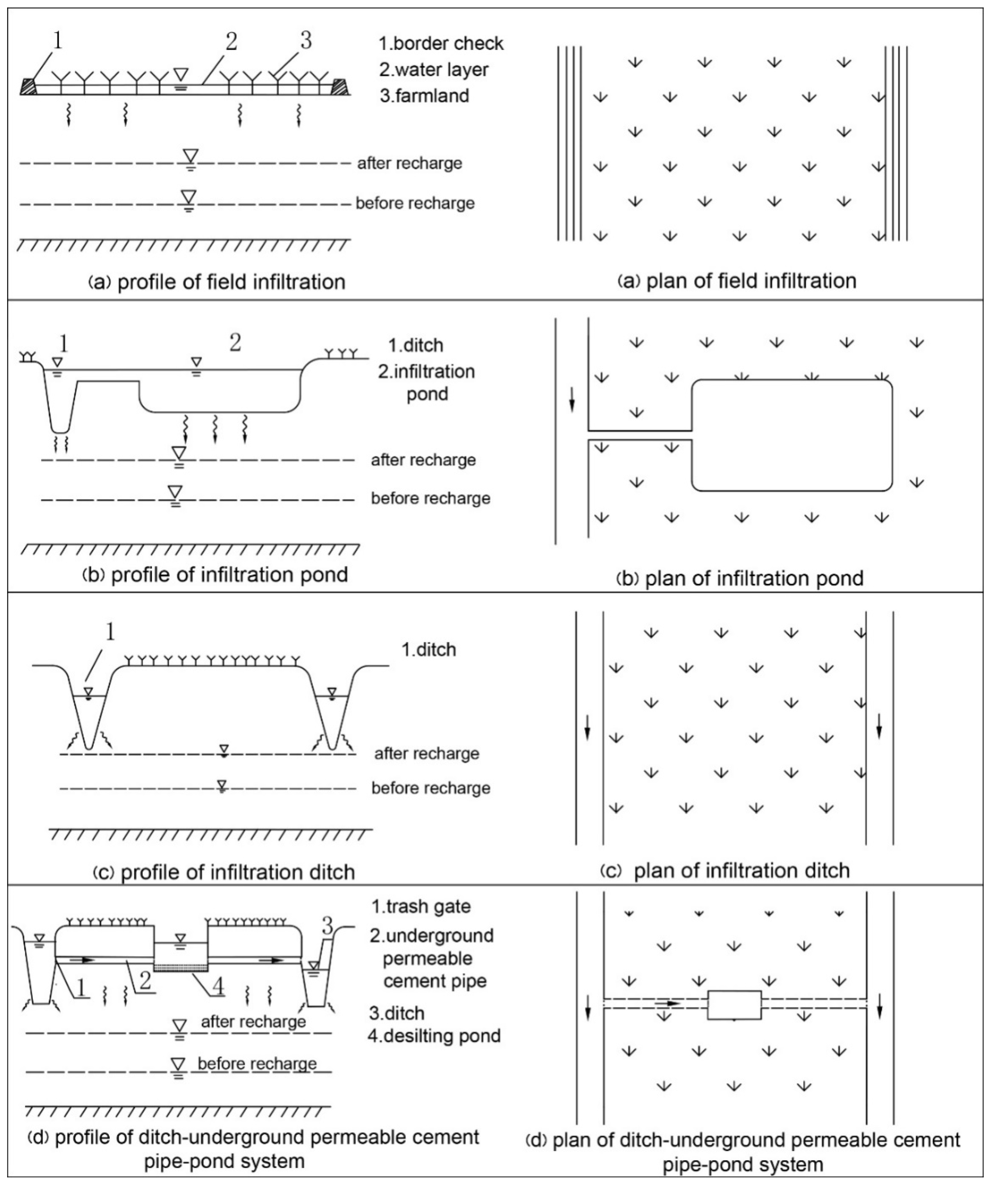
China has made many achievements in aquifer recharging, especially in industrial and agricultural production, urban water supply, and ecological protection [9,10,11]. The characteristics of MAR as a component of irrigation and drainage systems are as follows: small scale, short service life, low investment, fixed irrigation water sources, and crop planting structures. Considering these characteristics and the relationship between surface water and shallow aquifers, MAR is divided into three types: water spreading, well recharging, and a combination of both. MAR can be further divided into 10 types according to the specific farmland water conservancy project (Figure 1).
2.1.1. Water Spreading
The term “water spreading” refers to the release of water over the ground surface to increase the quantity of water infiltrating into the ground and percolating to the water table. Its characteristics are large influence areas, low investment, and high efficiency. It is divided into three types: field infiltration, infiltration pond, and infiltration ditch.
(a) Field infiltration: Field infiltration is achieved by check irrigation, flood irrigation, and large-scale winter irrigation, and it has the characteristics of steady water distribution and a wide range of influence. The amount of recharge is related to the irrigation quota and groundwater depth. ① Check irrigation: Water is diverted into fields with borders, and the thickness of the water layer is approximately 0.33 m. This method is carried out in winter wheat fields and white stubble land. Especially in coastal saline–alkali areas this method can be used to wash out soil salinity, dilute groundwater quality, and replenish groundwater. ② Flood irrigation: After water is injected into the recharge area through ditches, it is controlled by earthen embankments to make the water overflow. This method is suitable for flood plains with low slopes, old channels, sandy wastelands, woodlands, and orchards. ③ Winter irrigation with a large irrigation quota: In areas without check irrigation or flood irrigation conditions, large-quota winter irrigation can be used to recharge groundwater.
(b) Infiltration pond: Surface water is allowed to go through the unsaturated zone into the aquifer through natural ponds that are renovated and connected to conveyance canals. The characteristics of these ponds are low land occupation, a large amount of recharging, and a limited range of influence.
(c) Infiltration ditch: Infiltration ditches are the major method of recharging aquifers in North China. This method requires the selection of a reasonable ditch spacing. The infiltration water first forms a water peak along the ditch, then spreads from the ditch to both sides before reaching the center of the ditch.
(d) Ditch–underground permeable cement pipe-pond system: This system can be used in places with low permeability and a shortage of land. The diameter of the underground permeable cement pipe is more than 30 cm. A pond for desilting and lifting irrigation is built at a location 100 m away from the pipe head. When the pipe is buried as shallow as possible, it can also infiltrate the tilth topsoil and play an important role in irrigation.
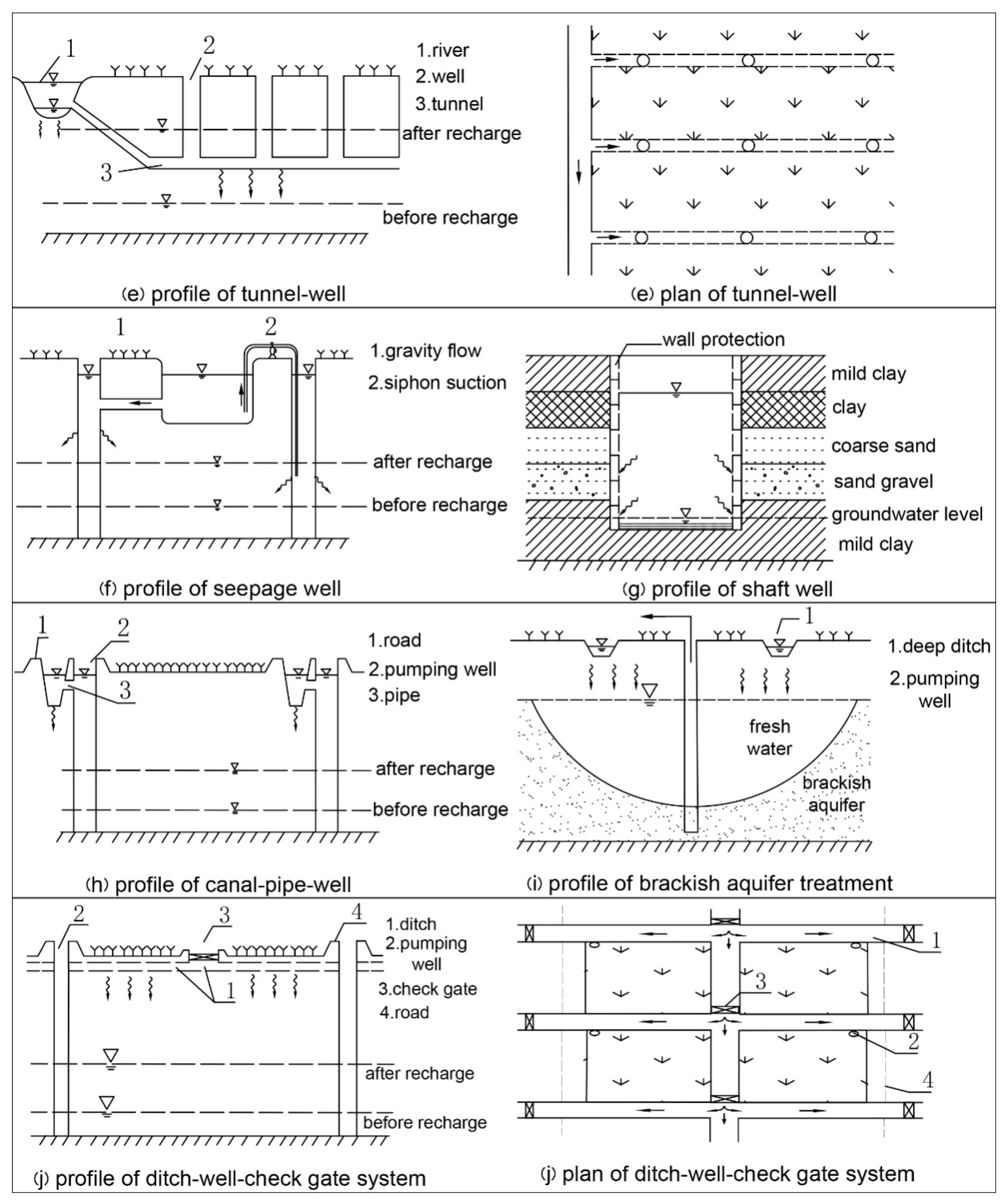
(e) Tunnel–well: This system consists of four parts: river, tunnels, wells, and artificial water lifting facilities. A tunnel with a width of 0.8 m and a height of 1 m is connected to the river and located in the clay layer 7–8 m below the ground. Each tunnel is several kilometers long, and there is a well for water lifting every 30 m. During the flood season this system can increase the amount of recharging and raise the groundwater table rapidly, with a better infiltration effect than those of other facilities.
2.1.2. Well Recharging
(f) Seepage well: Water can flow directly into the aquifer through shallow wells. This system, which is suitable for areas with deeply buried gravel aquifers, is faster than water spreading and has low land occupation, although clogging frequently occurs.
(g) Shaft well: The vertical shaft is used to expose the soil layer so that the water is admitted directly into the sandy gravel aquifer with high permeability. However, the bottom silt needs to be cleared regularly. When combined with (b) infiltration pond, better efficiency is observed.
2.1.3. Combination Methods
(h) Canal–pipe–well: The pumping well, which is connected to the canal by a pipe, lifts groundwater when the canal is waterless. The slope of the canal is gentle in the design, and the intake is more than 0.5 m above the bottom of the canal to reduce sedimentation.
(i) Brackish aquifer treatment: Brackish water is pumped through wells, and fresh water is diverted, stored, and infiltrated by deep ditches. The ditches can also be used for irrigation. Soil salinization can be controlled, and brackish aquifer can be desalinated.
(j) Ditch–well–check gate system: In plain areas, a number of check gates are added to ditches based on border checking, reticulated canal systems, and driven well groups. This system represents a farmland water conservancy system of diversion, storage, infiltration, water-saving, irrigation, and drainage.
2.2. Cases
2.2.1. Well-Canal Combination in the Yellow River Irrigation District
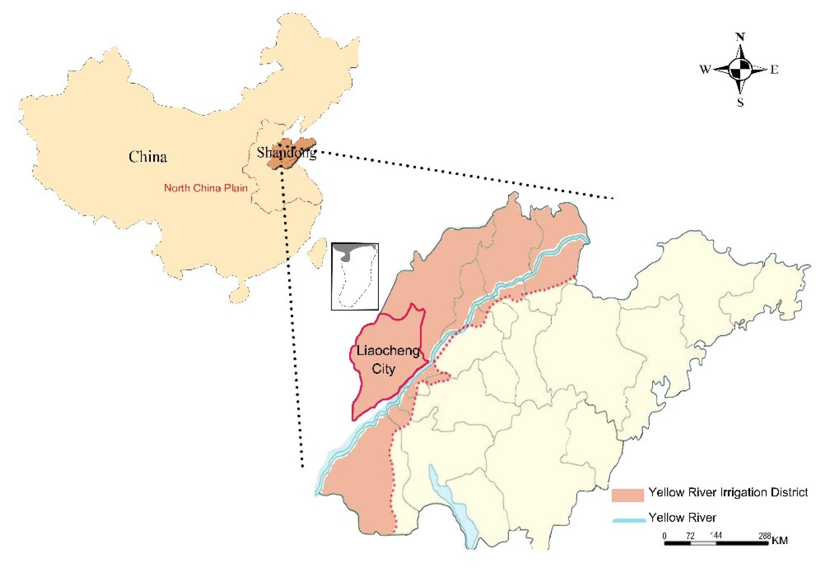
Overview of the Yellow River Irrigation District in Shandong Province
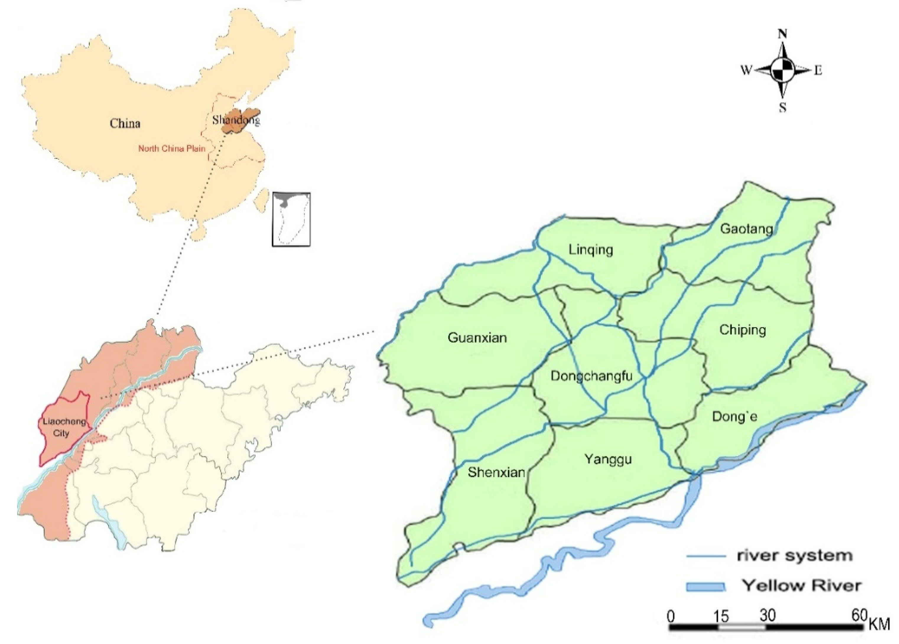
The Yellow River has a drainage area of 795,000 km2 and a length of 5464 km, making it the second-longest river in China. The Lower Yellow River flows through six cities in Shandong Province and ends at the Bohai Sea in Lijin County, covering about one-third of Shandong Province [12]. The area has a warm temperate monsoon climate. The average annual rainfall is 606 mm, and the average annual evaporation is 1300 mm. Rainfall is mainly concentrated in the summer; thus, the area presents characteristics of spring and autumn droughts and summer floods. The Yellow River flood plain is the main part of the North China Plain. Due to the long-term geological movements and the sedimentary rhythm in the downstream area of the Yellow River, the formation is deep and the aquifer media are dominated by fine sand with a hydraulic conductivity of 0.3–2.5 m/day [13]. The area can be divided into three aquifers from top to bottom. The most important water supply for agriculture is phreatic water, with a buried depth of 0–60 m, a roof depth of 10–25 m, a thickness of 10–25 m, and a well yield of 6–10 m3/h·m. The lithology of the unsaturated zone and the characteristics of the shallow aquifer provide favorable conditions for recharging aquifers and exploiting shallow groundwater. The Yellow River Irrigation District of Shandong province is shown in Figure 2. The designed irrigation area of the Yellow River of Shandong province is 16,667 km2. The average annual water diversion for agriculture in the Yellow River Irrigation District is 4.5 billion m3 (1995–2015). The main crops are winter wheat, corn, and cotton, with a multiple cropping index of 1.7. With the influence of inadequate local water resources, unreliable Yellow River water available in the low Yellow River flow years, and uneven distribution of water between upstream and downstream of the Yellow River Irrigation District, the shallow groundwater overexploitation area has reached 4500 km2. In short, the Yellow River Irrigation District is facing drought, flooding, and sediment problems [14].
The Yellow River Irrigation District of Shandong Province is 16,667 km2, and only 12% of this area uses gravity irrigation. Therefore, three irrigation-drainage modes have been established. (1) Irrigation and drainage systems are separated and use gravity flow. The canals of the irrigation system (including the main, branch, lateral, and sublateral canals) are above ground, while the corresponding ditches of the drainage system are underground. The drainage water enters the Bohai Sea through the river. (2) Irrigation and drainage systems are separated, and water is pumped from the canal for irrigation and gravity drainage. The canals of the irrigation system and the ditches of the drainage system are underground. The ditches are deeper than the canals to ensure that the drainage water can flow into the river under the influence of gravity. (3) The well–canal combination, which is the most commonly used mode of irrigation and drainage, is a combination of irrigation and drainage systems.
Well-Canal Combination Mode
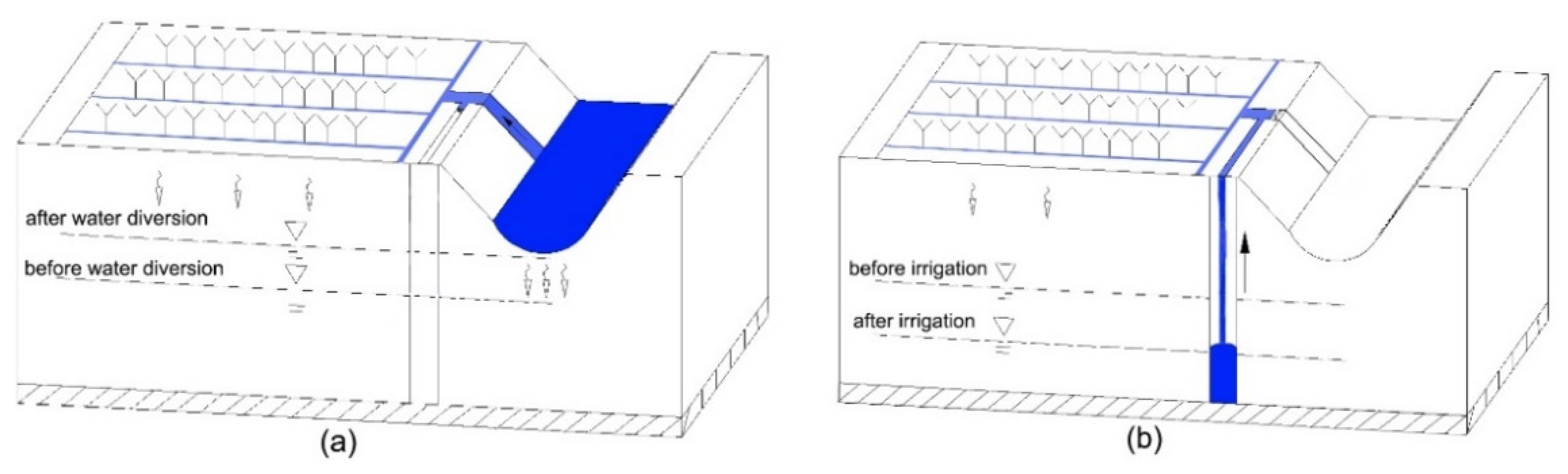
With the urbanization and industrialization of the Yellow River Irrigation District, the water distribution has shifted from agricultural irrigation to urban water supplies. Yellow River diversion occurs over a limited time; thus, although the Yellow River water is available, the flow is unreliable. Therefore, the well–canal combination mode is inevitably adopted to achieve a large-scale steady production increase in agriculture [15,16,17]. The well-canal combination mode is a double irrigation system, which has the advantages of recharging aquifers with river water through canal infiltration and irrigation return flow, and guaranteeing bumper harvests with wells (Figure 3). The canal has multiple functions of water delivery, storage, infiltration, irrigation by pumping, and drainage [18].
Historically, flood irrigation was widely used in the fields of the Yellow River Irrigation District; therefore, irrigation return flows became the main source of groundwater recharging. The irrigation efficiency and overall benefit of the Yellow River Irrigation District are low. At present, low-pressure pipeline irrigation has been widely used, resulting in a lower irrigation quota and irrigation return flow, a higher irrigation application efficiency, and lower groundwater pollution by soil leaching. The amount of groundwater recharged in this way is much less than that from flood irrigation. The method mainly depends on the leakage from canals after implementing the water saving measures, and does not pass through the plow layer and thus does not pollute the shallow groundwater. The wide use of the well–canal combination maintains the balance of diversion water and groundwater and has a good effect in regulating the groundwater table.
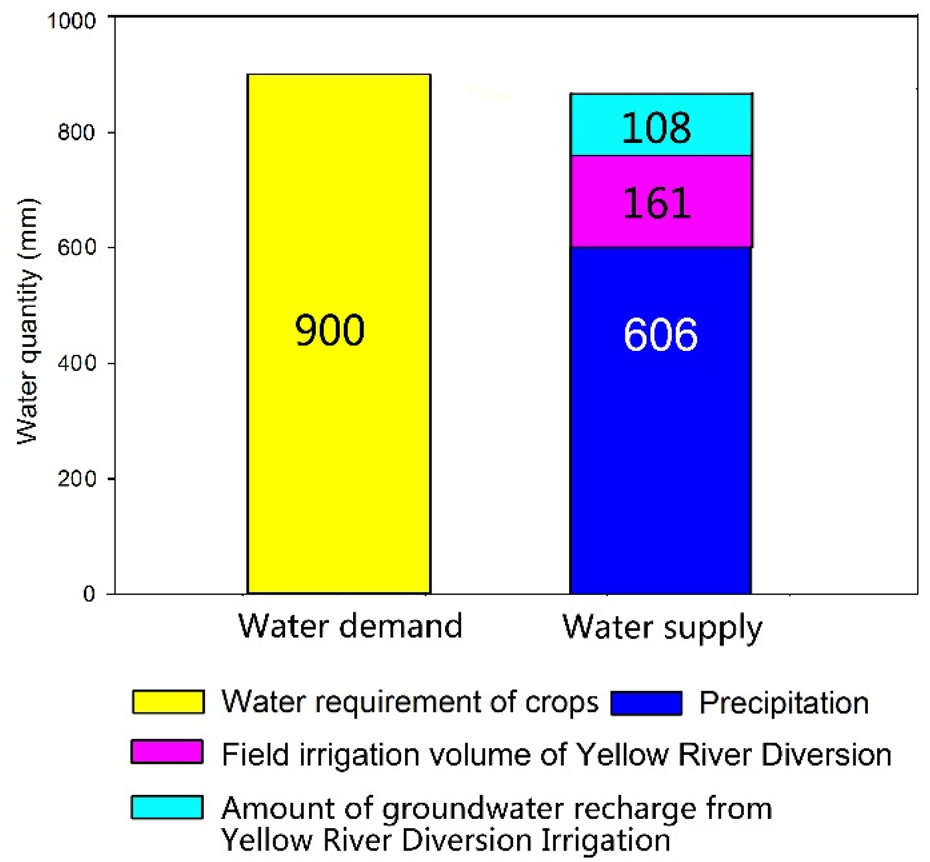
Figure 4 shows the water balance of the Yellow River Irrigation District with a 50% probability of precipitation. When the probability of precipitation is 50%, the total water demand of the main crops is 900 mm and the precipitation is 606 mm, of which 182 mm is infiltrated into the ground. Therefore, the water deficiency is 294 mm. The 269 mm of Yellow River water diversion can fill the water deficiency. The irrigation efficiency of Yellow River Irrigation District is 0.6. The average annual available local water can only guarantee 67% of the irrigation water requirement, and the rest needs to be provided by the Yellow River, of which the field irrigation volume is 161 mm and accounts for 60% of the total amount of Yellow River Diversion, and the remaining 108 mm accounts for 40% of the total, which can be pumped by well to irrigate crops for harvesting from the groundwater recharged through canal system infiltration and irrigation return flow. The Yellow River water diversion has played a key role in stable agricultural production and high yields. When the irrigation water ratio of well to canal is 1:0.93, the irrigation water in this area basically maintains a balance of supply and demand. In addition, other research has shown that when the irrigation water ratio of well to canal is at 1:0.78 in the People’s Victory Canal Irrigation District of neighboring Henan Province, it can basically maintain the balance of supply and demand [19]. If water balance is reached in the water deficient area by Yellow River water diversion, this mode is influenced by irrigation efficiency. The irrigation water ratio of well to canal would decrease with increases in irrigation efficiency, resulting in a decreased capacity for groundwater regulation. So, the question is how to enlarge the groundwater recharge amount through Yellow River water diversion over a limited time [20,21,22].
2.2.2. Open Channel-Underground Perforated Pipe-Shaft–Water Saving Irrigation System
With the large-scale promotion of water saving practices in the Yellow River Irrigation District, the flood irrigation method is no longer suitable. However, the canal system has already been formed. If new canals are dug, then they will occupy a large amount of cultivated land. Therefore, considering the existing irrigation-drainage system, a method of increasing the recharge rate of shallow groundwater overexploitation areas must be identified.
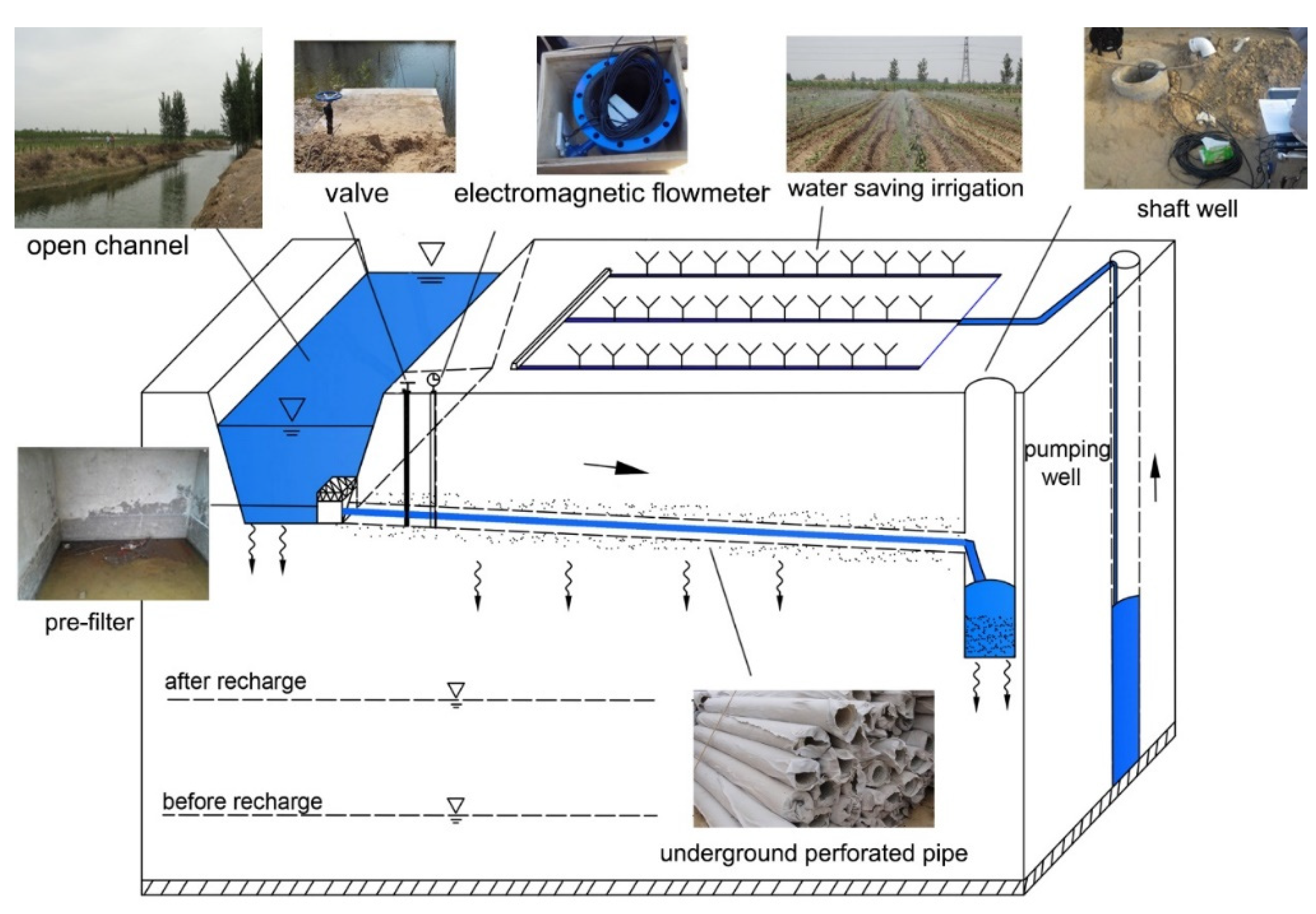
An open channel–underground perforated pipe–shaft–water saving irrigation system with high efficiency and ecology has been developed based on infiltration ditches, the combined tunnel–well mode, modern materials, and filtration technology (Figure 5). The underground perforated pipe is used to further increase the recharge rate and influence area, and to restore the groundwater overexploitation zone. The system consists of the Yellow River water source, open channels, prefilters, perforated pipes, dredging shafts, crops, irrigation systems, ambient groundwater systems, operation and monitoring facilities, equipment (e.g., electromagnetic flowmeters), and so on.
Three measures to prevent sediment blockage are set up in the recharging system. (1) A prefilter tank is provided at the canal head. (2) A 20-cm sand layer is placed around the pipe in the soil of the designed section, where the geotextile can prevent the outer sediments from entering into the pipe. The pipe has a certain slope and a dual function of water washing and seepage. (3) Shafts with well filters in the borehole are at the end of the recharge system, and they can not only receive the sediments but also contribute to the water seepage. The specific parameters of the recharge system are as follows: the bottom area of the prefilter tank is 4 m2, and the underground perforated pipe is composed of plastic blind ditches with a diameter of 30 cm, a slope of 1/500, a pipe length of 200 m, and a shaft depth of 10 m. The parameters can be adjusted according to different regions and local conditions.
In the practical project, the system was conducted at a recharge area of 54,000 m2 including three underground perforated pipes as subsystem and buried pipes spaced 90 m apart with 200 m lengths. According to the calculation by an analytical method, the project contributed a groundwater recharge amount of 52,310 m3, covering 60.7% of the total replenished water. The numerical simulation results showed that the groundwater table under the pipe rose 8.5 m throughout the simulation period. In the seven-day simulation period, the total infiltration amount of the open channel was 33,861 m3, and the total infiltration amount of the pipes was 56,224 m3, which accounted for 62.4% of the total infiltration amount [23]. In summary, this project has the advantages of no energy consumption, no land occupation, managed groundwater recharging, irrigation drainage, and water logging control, and it plays an important role in the recovery of groundwater funneling.
3. Adaptability Zoning Evaluation
3.1. Study Area
Liaocheng City is part of the North China Plain and is located in the northwestern part of Shandong Province and the western part of the Yellow River Basin, with good water diversion conditions (Figure 6). The terrain is flat, and the total area is 8715 km2. Liaocheng City is a large agricultural city with an average annual precipitation of 560 mm, a cultivated land area of 6353 km2, and an effective irrigation area of 4947 km2. The groundwater depth of shallow aquifers as irrigation water sources is 0–60 m. Most rivers are approximately parallel and flow from the southwest to the northeast. The rivers have a crossing and repeated sedimentary structure in the vertical direction. In the horizontal direction, the land can be divided into an accumulation area, a flood plain alternating area, and an interstream area, wherein the aquifer media become finer, the thickness decreases, and the water abundance weakens. The aquifer is composed of fine sand with a thickness of 10–25 m, fine sand with a thickness of 5–10 m, and silt with a thickness of less than 5 m. The main irrigation water sources are groundwater, water diverted from the Yellow River, and a small amount of surface water. Over the past 60 years, the number of agricultural irrigation wells has increased rapidly to guarantee bumper harvests. Groundwater continues to be overexploited, and the groundwater table is declining in part of this area. Therefore, to ensure that the combined use of surface water and groundwater sustain crop yields and also groundwater storage levels, the types and densities of recharge mechanisms need to be adapted to the local intensity of water use and hydrogeological conditions. For these, zones were identified where water-spreading mechanisms were considered appropriate.
The constraint conditions for an adaptability zoning evaluation of MAR are as follows: (1) phreatic aquifers; (2) agricultural irrigation; (3) a Yellow River water recharge water source and a small amount of surface runoff during the flood season; and (4) the MAR project aim of a water spreading method, including indirect recharging methods such as field infiltration, infiltration ponds, ditches, and so on.
3.2. Evaluation Factors
An adaptability zoning evaluation means selecting a suitable recharge area to water spreading for irrigation, a process that is influenced by many factors. Based on the hydrogeological conditions of groundwater extraction, the evaluation focuses on the water-bearing characteristics of the vertical vadose zone during recharge. There are five factors for consideration: groundwater depth, thickness of the fine sand, specific yield, irrigation return flow, and groundwater extraction intensity.
Evaluation of groundwater vulnerability and recharge adaptability have similarities and differences in surface water infiltration. The process of the DRASTIC model can be used as a reference. The rating range for each evaluation factor is 1–5 points, for which the higher points correspond to a better adaptability of MAR for water spreading (Table 1). The overall score is calculated by equal weight.
Because the five factors have different effects on groundwater recharge, they should be classified. The factors affecting the water storage capacity are groundwater depth, thickness of the fine sand, specific yield, and irrigation return flow (after decades of field experiments, abundant county-level data are available). The groundwater extraction intensity is equivalent to the user demand for recharge water. The lithology of the aquifer (0–60 m) is mainly fine sand, and the permeability coefficient is similar to that for a typical sand material. Therefore, the thickness of the fine sand can effectively represent the basic characteristics of Liaocheng City. Most data can be obtained from geologic reports and relevant departments, which are frequently used in groundwater resource assessments in the study area.
3.2.1. Groundwater Depth
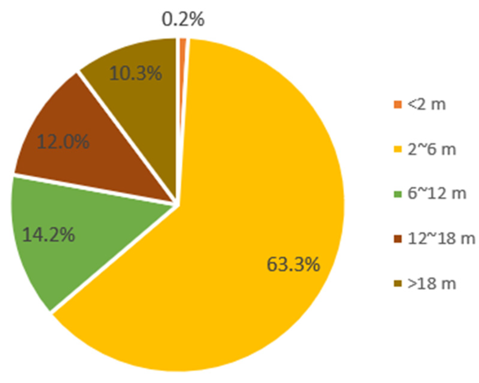
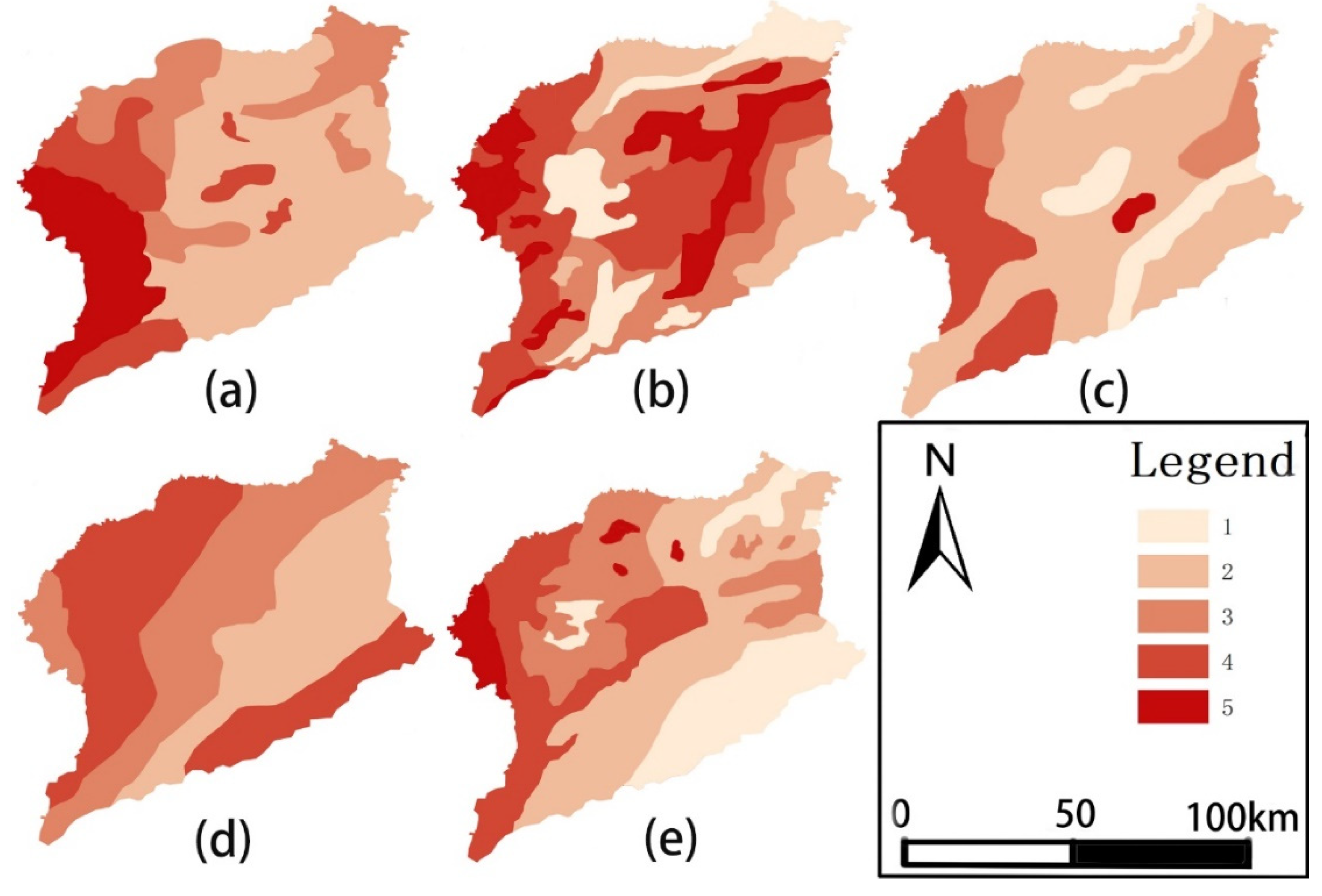
Groundwater depth refers to the status of groundwater overexploitation. Statistical data for 2016 indicated that there was an area of 898 km2 with a groundwater depth greater than 18 m, and this accounted for 10.3% of the total area. This area has a large demand for recharge, and the highest evaluation score of 5 points was observed when the aquifer had a sufficient recharge time and amount of water. The area with a groundwater depth between 12 and 18 m was 1043 km2, which accounted for 12% of the total area, and the evaluation score was 4 points. The area with a groundwater depth between 6 and 12 m was 1240 km2, which accounted for 14.2% of the total area, and the evaluation score was 3 points. The area with a groundwater depth between 2 and 6 m was 5517 km2, which accounted for 63.3% of the total area, and the evaluation score was 2 points. The area with a groundwater depth less than 2 m was 16 km2, which accounted for 0.2% of the total area. Such areas have a small demand for recharge, and the score of this area was 1 point (Figure 7).
3.2.2. Thickness of Fine Sand
Thickness of fine sand refers to the water abundance characteristics of shallow aquifers. Values are the cumulative thickness of fine sand (0–60 m). The existing data were obtained by a large number of geological surveys conducted by the relevant departments. The area with a thickness of fine sand less than 5 m accounted for 15.1% of the total area. The water storage space was not large, and the score is the smallest at one point. The areas with thicknesses of 5–10 m and 10–15 m accounted for 11.4% and 17.3% of the total area and presented scores of 2 and 3 points, respectively. Areas with thicknesses of 15–20 m and greater than 20 m accounted for 38.4% and 17.7% of the total area and presented scores of 4 and 5 points, respectively.
3.2.3. Specific Yield
Specific yield (μ) refers to the storage property of the formation (0–60m). A larger value of μ corresponds to a better water storage capacity. The corresponding values from 0.05 to 0.11 are based on the research results of the relevant departments. The specific yield can be obtained by the equation
where α is the recharge coefficient of precipitation, P is the precipitation (mm), and Δh is the change in water level (mm).
3.2.4. Irrigation Return Flow
Because the irrigation water quota is larger than individual rainfall under the same planting structure, groundwater depth, and uniform water distribution on farmland, irrigation return flow can better represent the hydraulic conductivity of unsaturated zones as the water spreading of MAR than with the recharge coefficient of precipitation.
where β is the irrigation return flow, Q is the amount of irrigation water (mm), Δh is the change in water level (mm), and μ is the specific yield of the area.
According to the above method, the relevant departments obtained the irrigation return flow through multiple irrigation experiments with an empirical value of 0.01-0.35. The larger the β is, the more permeable the unsaturated zone is.
3.2.5. Groundwater Extraction Intensity
Groundwater extraction intensity not only refers to water demand but also to impact on a groundwater system. The empirical values of groundwater extraction intensity for irrigation in the study area were 9.1~18.3 × 10⁴m3/a·km2. Groundwater extraction intensity was equal to the ratio of extraction volume to irrigation area.
3.3. Results
The maps of the five factors are as follows: (a) groundwater depth, (b) thickness of fine sand, (c) specific yield, (d) irrigation return flow, and (e) groundwater extraction intensity (Figure 8). The map is divided into 1~5 points based on the hydrogeological data.
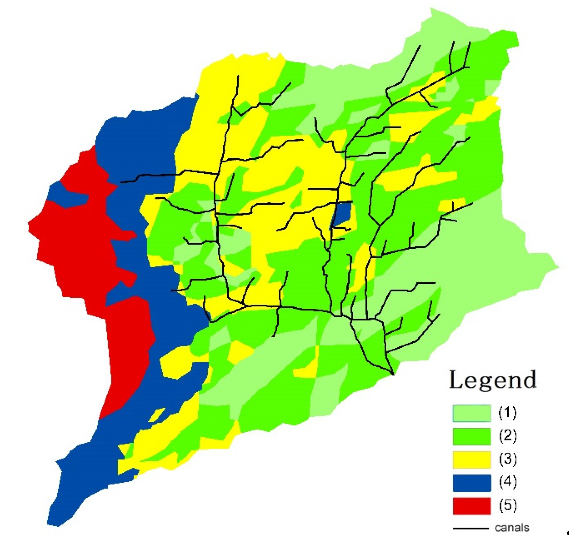
Based on the scores of the five evaluation factors, ArcGIS (10.2, Esri, Beijing, China) was used to evaluate the applicability in the study area. Through spatial analyst of ArcGIS, the evaluation results were divided into five levels by their natural breaks (jenks): (1) unsuitable area, (2) small potential area, (3) general potential area, (4) medium potential area, and (5) high potential area. The zoning map for the adaptability zoning evaluation is obtained by ArcGIS in accordance with the spatial distribution of the recharge potential (Figure 9).
The results show that the western part of Liaocheng City is a suitable area for MAR. The overall score of the western region was higher because of the greater groundwater depth, thicker sand layer, and higher groundwater exploitation. Especially in Guanxian County, the groundwater depth was approximately 20 m, the thickness of the fine sand layer was the thickest, and the specific yield was the highest. This area is the high-potential area, while the medium-potential areas were near Linqing and Shenxian counties. The eastern part of Liaocheng City had a groundwater depth of 2 to 6 m. The thickness of the fine sand layer was relatively large, but the urgency of recharge was small. Therefore, the eastern part mainly had areas with less potential or that were unsuitable.
The main existing MAR project is the well–canal combination mode in Liaocheng City. The existing MAR project needs to be strengthened in the western region via water spreading methods, in which areas (4) and (5) are located at the end of the irrigation district of Liaocheng City. A new mode of the open channel–underground perforated pipe–shaft–water saving irrigation system should be extended in order to increase the groundwater recharge amount and expand the scope of groundwater recharge during the limited Yellow River water diversion period.
4. Discussion and Conclusions
In the 1970s and 1980s, various small-scale MAR projects were implemented to increase the amount of shallow groundwater in the North China Plain. Considering these characteristics and the relationship between surface water and shallow aquifers, MAR is divided into the three types: water spreading, well recharging, and a combination of both. MAR can be further divided into 10 forms according to the specific farmland water conservancy project (field infiltration, infiltration pond, infiltration ditch, ditch–underground permeable cement pipe–pond systems, tunnel–wells, seepage wells, shaft wells, canal–pipe–wells, brackish aquifer treatment, and ditch–well–check gate systems). These projects guarantee high grain yields and maintain the balance between recharging and extraction.
The Yellow River Irrigation District of Shandong Province is located in the lower reaches of the Yellow River. The effective irrigation area is mainly based on well irrigation. With the increase of crops, the water demand for agricultural irrigation has increased rapidly. Local groundwater can only provide half of the irrigation water, and Yellow River water diversion is performed to supplement irrigation. Large-scale overexploitation of shallow groundwater has occurred in some areas. The well–canal combination mode has been widely used in the Yellow River Irrigation District of Shandong Province for nearly 40 years. Because the well–canal mode has many advantages, it is applicable to the downstream, middle-stream, or upstream areas of the Yellow River Irrigation District. During water diversion, the water of the Yellow River is diverted by deep canals and relies on pumping irrigation and gravity drainage. As irrigation proceeds by pumping from canals, part of the water in the canals is recharged to the groundwater, which improves irrigation conditions. Without water diversion, the water demand can be satisfied by well irrigation. This mode has the advantage of recharging aquifers with river water and guaranteeing bumper harvests with wells. It also not only maintains high crop yields and basically guarantees the balance of exploitation and the recharging of shallow groundwater, but it solves the problem of aquifers being clogged by sediment from the Yellow River diversion because silt sediment at the canal head and sediment in the canal are dredged.
Based on field infiltration, infiltration ditches, and infiltration ponds, a new open channel–underground perforated pipe–shaft–water saving irrigation system was developed. The new system further expands the recharge scope and replenishment, and has three anti-blocking measures. The sustainable development of agriculture in the North China Plain is ensured by implementing the well–canal combination mode and adopting shallow groundwater recharge as the main line. The method of integrating MAR into agricultural facilities to form a farmland water conservancy system of water diversion, storage, infiltration, water savings, irrigation, and drainage is proposed to achieve the goal of comprehensively controlling droughts, floods, and salinization.
Liaocheng City was selected as the study area because of the distribution of aquifers, permeability of the unsaturated zone, and groundwater extraction intensity in the Yellow River Irrigation District of Shandong Province. An adaptability zoning evaluation system for water spreading was established based on the common modes of water spreading. Five factors were selected to reflect unsaturated zones and groundwater extraction: groundwater depth, thickness of fine sand, specific yield, irrigation return flow, and groundwater extraction intensity. The results show that MAR projects are adaptable to the western region and can resolve agricultural irrigation problems. The eastern and central regions have high groundwater tables, better diversion conditions for the Yellow River, and superior aquifer water storage capacities. However, these areas are not suitable for MAR projects due to their low groundwater extraction intensity. Thus, water diversion from the Yellow River and groundwater exploitation should be maintained in balance.
Author Contributions
This paper was composed by collaboration among all authors. Supervision, S.Q., Y.Z. and W.L.; Writing—original draft, S.L.; Writing—review & editing, W.W. All authors have read and agreed to the published version of the manuscript.
Funding
This study was supported by the Shandong Provincial Key Research and Development Project (2017GSF17121) and the Danish Development Agency (DANIDA) coordinated by the DANIDA Fellowship Center (DFC) through grant No. 17-M08-GEU.
Acknowledgments
The authors would like to acknowledge the editor and three anonymous reviewers for their valuable comments, which have greatly improved this paper.
Conflicts of Interest
The authors declare no conflict of interest.
References
- Dillon, P.; Stuyfzand, P.; Grischek, T.; Lluria, M.; Pyne, R.D.G.; Jain, R.C. Sixty years of global progress in managed aquifer recharge. Hydrogeol. J. 2019, 27, 1–30. [Google Scholar] [CrossRef] [Green Version]
- Changming, L.; Jingjie, Y.; Kendy, E. Groundwater Exploitation and Its Impact on the Environment in the North China Plain. Water Int. 2001, 26, 265–272. [Google Scholar] [CrossRef]
- Ahmed, A.A. Using Generic and Pesticide DRASTIC GIS-based models for vulnerability assessment of the Quaternary aquifer at Sohag, Egypt. Hydrogeol. J. 2009, 17, 1203–1217. [Google Scholar] [CrossRef]
- Saidi, S.; Bouri, S.; Dhia, H.B. Groundwater vulnerability and risk mapping of the hajeb-jelma aquifer (central tunisia) using a gis-based drastic model. Environ. Earth Sci. 2010, 59, 1579–1588. [Google Scholar] [CrossRef]
- Hamza, S.M.; Ahsan, A.; Imteaz, M.A.; Rahman, A.; Mohammad, T.A.; Ghazali, A.H. Accomplishment and subjectivity of GIS-based DRASTIC groundwater vulnerability assessment method: A review. Environ. Earth Sci. 2015, 73, 3063–3076. [Google Scholar] [CrossRef]
- Wang, W.P.; Dillon, P.; Vanderzalm, J. New Progress in Aquifer Recharge Management between China and Australia; The Yellow River Water Conservancy Press: Jinan, China, 2009; pp. 79–83. [Google Scholar]
- Dillon, P. Future management of aquifer recharge. Hydrogeol. J. 2005, 13, 313–316. [Google Scholar] [CrossRef]
- Asano, T.; Wassermann, K.L. Groundwater recharge operations in California. J. Am. Water Works Assoc. 1980, 72, 380–385. [Google Scholar] [CrossRef]
- Cao, G.; Scanlon, B.R.; Han, D.; Zheng, C. Impacts of thickening unsaturated zone on groundwater recharge in the North China Plain. J. Hydrol. 2016, 537, 260–270. [Google Scholar] [CrossRef]
- Min, L.; Shen, Y.; Pei, H. Estimating groundwater recharge using deep vadose zone data under typical irrigated cropland in the piedmont region of the North China Plain. J. Hydrol. 2015, 527, 305–315. [Google Scholar] [CrossRef]
- Huang, T.; Pang, Z. Groundwater Recharge and Dynamics in Northern China: Implications for Sustainable Utilization of Groundwater. Procedia Earth Planet. Sci. 2013, 7, 369–372. [Google Scholar] [CrossRef] [Green Version]
- Wang, Z.; Liu, C. Two-thousand years of debates and practices of Yellow River training strategies. INT J. Sediment Res. 2019, 34, 73–83. [Google Scholar] [CrossRef]
- Li, X.; Zhong, D.; Zhang, Y.J.; Wang, Y.; Wang, Y.; Zhang, H. Wide river or narrow river: Future river training strategy for Lower Yellow River under global change. INT J. Sediment Res. 2018, 33, 271–284. [Google Scholar] [CrossRef]
- Zhang, K.; Xie, X.; Zhu, B.; Meng, S.; Yao, Y. Unexpected groundwater recovery with decreasing agricultural irrigation in the Yellow River Basin. Agric. Water Manag. 2019, 213, 858–867. [Google Scholar] [CrossRef]
- Xu, X.; Huang, G.H.; Qu, Z.Y. Integrating MODFLOW and GIS technologies for assessing impacts of irrigation management and groundwater use in the Hetao Irrigation District, Yellow River basin. Sci. China 2009, 52, 3257–3263. [Google Scholar] [CrossRef]
- Sun, H.Y.; Wang, S.F.; Hao, X.M. An Improved Analytic Hierarchy Process Method for the evaluation of agricultural water management in irrigation districts of north China. Agric. Water Manag. 2017, 179, 324–337. [Google Scholar] [CrossRef]
- Mao, W.; Yang, J.; Zhu, Y.; Ye, M.; Wu, J. Loosely coupled SaltMod for simulating groundwater and salt dynamics under well–canal conjunctive irrigation in semi-arid areas. Agric. Water Manag. 2017, 192, 209–220. [Google Scholar] [CrossRef]
- Zhou, Z.M.; Zhou, K.; Wang, X.C. Influence of Irrigation Water-Saving on Groundwater Table in the Downstream Irrigation Districts of Yellow River. Adv. Intell. Soft Comput. 2012, 138, 79–83. [Google Scholar] [CrossRef]
- Zhang, J.X.; Qi, X.B.; Magzum, M. Appropriate Well–canal Irrigation Proportion in Irrigation District Based on MODFLOW and GIS. J. Irrig. Drain. 2017, 36, 58–63. (In Chinese) [Google Scholar] [CrossRef]
- Chen, L.L.; Sun, Y.; Yang, Y.G. Benefit analysis of well canal combined irrigation in Yellow River Diversion Irrigation Area of Henan Province. Yellow River 2011, 33, 92–93. (In Chinese) [Google Scholar] [CrossRef]
- Qi, X.B.; Fan, X.Y.; Wang, J.L. Optimal allocation of water resources in well–canal combined irrigated area for high efficient utilization of water. J. Hydraul. Eng. 2004, 10, 119–124. (In Chinese) [Google Scholar] [CrossRef]
- Liu, L.; Luo, Y.; He, C.; Lai, J.; Li, X. Roles of the combined irrigation, drainage, and storage of the canal network in improving water reuse in the irrigation districts along the lower Yellow River, China. J. Hydorl. 2010, 391, 157–174. [Google Scholar] [CrossRef]
- Rong, Q.; Wang, W.; Qu, S.; Li, J.; Li, F.; Xu, Q. A MAR to address the water with high content of suspended solid with a case study in the Yellow River flood plain, China. Agric. Water Manag. 2017, 182, 165–175. [Google Scholar] [CrossRef]
Figure 1.
Specific types of MAR in agricultural irrigation.


Figure 2.
Yellow River Irrigation District of Shandong Province.

Figure 3.
Well–canal combination mode (a) with Yellow River water diversion and (b) without Yellow River water diversion.
Figure 3.
Well–canal combination mode (a) with Yellow River water diversion and (b) without Yellow River water diversion.

Figure 4.
Water balance of the Yellow River Irrigation District at 50% probability of precipitation.
Figure 4.
Water balance of the Yellow River Irrigation District at 50% probability of precipitation.

Figure 5.
Open channel–underground perforated pipe–shaft–water saving irrigation system.

Figure 6.
Location of Liaocheng City.

Figure 7.
Corresponding areas of different groundwater depths.

Figure 8.
Maps of the five factors. (a) groundwater depth, (b) thickness of fine sand, (c) specific yield, (d) irrigation return flow, and (e) groundwater extraction intensity.
Figure 8.
Maps of the five factors. (a) groundwater depth, (b) thickness of fine sand, (c) specific yield, (d) irrigation return flow, and (e) groundwater extraction intensity.

Figure 9.
Adaptability zoning map of recharge and existing canal system in the Yellow River Irrigation District of Liaocheng City.
Figure 9.
Adaptability zoning map of recharge and existing canal system in the Yellow River Irrigation District of Liaocheng City.


Table 1.
Grading of evaluating factors.
| Factor | Level | ||||
|---|---|---|---|---|---|
| 1 | 2 | 3 | 4 | 5 | |
| groundwater depth (m) | <2 | 2~6 | 6~12 | 12~18 | >18 |
| thickness of fine sand (m) | <5 | 5~10 | 10~15 | 15~20 | >20 |
| specific yield | <0.05 | 0.05~0.07 | 0.07~0.09 | 0.09~0.11 | >0.11 |
| irrigation return flow | <0.01 | 0.01~0.1 | 0.1~0.2 | 0.2~0.35 | >0.35 |
| groundwater extraction intensity (104 m3/a·km2) | <9.1 | 9~11 | 11~14.6 | 14.6~18.3 | >18.3 |
© 2020 by the authors. Licensee MDPI, Basel, Switzerland. This article is an open access article distributed under the terms and conditions of the Creative Commons Attribution (CC BY) license (http://creativecommons.org/licenses/by/4.0/).
Share and Cite
MDPI and ACS Style
Liu, S.; Wang, W.; Qu, S.; Zheng, Y.; Li, W. Specific Types and Adaptability Evaluation of Managed Aquifer Recharge for Irrigation in the North China Plain. Water 2020, 12, 562. https://doi.org/10.3390/w12020562
AMA Style
Liu S, Wang W, Qu S, Zheng Y, Li W. Specific Types and Adaptability Evaluation of Managed Aquifer Recharge for Irrigation in the North China Plain. Water. 2020; 12(2):562. https://doi.org/10.3390/w12020562
Chicago/Turabian StyleLiu, Shuai, Weiping Wang, Shisong Qu, Yan Zheng, and Wenliang Li. 2020. "Specific Types and Adaptability Evaluation of Managed Aquifer Recharge for Irrigation in the North China Plain" Water 12, no. 2: 562. https://doi.org/10.3390/w12020562
Note that from the first issue of 2016, this journal uses article numbers instead of page numbers. See further details here.