Terraced Landscapes on Portofino Promontory (Italy): Identification, Geo-Hydrological Hazard and Management
by
 , , , and
Guido Paliaga
1 ,
,
Fabio Luino
1 ,
,
Laura Turconi
1,
Jerome V. De Graff
2 and
Francesco Faccini
1,3,*
1
Research Institute for Geo-Hydrological Protection, National Research Council, Strada delle Cacce 73, 10135 Torino, Italy
2
Department of Earth & Environmental Science, California State University, M/S ST24, Fresno, CA 93740, USA
3
Department of Earth, Environmental and Life Sciences, University of Genova, Corso Europa, 26–16132 Genova, Italy
*
Author to whom correspondence should be addressed.
Water 2020, 12(2), 435; https://doi.org/10.3390/w12020435
Submission received: 30 December 2019
/
Revised: 25 January 2020
/
Accepted: 3 February 2020
/
Published: 6 February 2020
(This article belongs to the Special Issue Terraced Landscapes and Hydrological-Geological Hazards)
Abstract
:Stone wall terraces are a largely investigated topic in research for both their landscape and cultural/historical value. Terraces are anthropogenic landforms that interact with natural processes and need permanent maintenance to preserve their functionality. In the Mediterranean region, ground effects related to intense rain events often involve terraced slopes that, in some situations, are directly sourced areas of debris/mud flow. Starting from the 1950s, the changing socio-economic conditions caused the abandonment of large portions of rural areas. Nowadays, at the catchment scale, it is frequently difficult recognizing stone wall terraces because of their abandonment and the uncontrolled re-vegetation. This research faces the issue of identifying terraces in the Monte di Portofino promontory, which is internationally famous for its high-value natural and landscape involving broad anthropogenic modifications dating back to the Middle Ages. A remote sensing application, with LIDAR data and orthophotography, identified terraces on the Portofino promontory, enabling investigating even barely accessible areas and increasing knowledge on the territory. The aim of this paper is first of all to point out the presence of such anthropogenic morphologies in the promontory of Monte di Portofino and then to asses and highlight the related hazard. In fact, terraces can be a source of debris/hyper-concentrated flow with highly damaging power, as occurred in the recent years in neighboring areas during particularly intense hydrological events. Then, terraced area mapping, including in use and in abandonment information, is crucial to perform a spatial relationship analysis that includes hazard-exposed elements and to evaluate the possible connectivity factor of buildings, infrastructures, tourism facilities and Cultural Heritage within the hydrographical network.
1. Introduction
Recently, research interest on terraces has been increasing [1,2,3,4,5,6], in part due to 2018 “Art of dry-stone walling, knowledge and techniques” inclusion in UNESCO–United Nations Educational Scientific and Cultural Organization-Intangible Cultural Heritage [7], while some peculiar landscapes, such as Portovenere, Cinque Terre, and the Islands’ terraced vineyards, were already part of the UNESCO Heritage Site. Terraces are commonly recognized as a crucial component of agricultural practices both for the cultural value they represent and for their importance in food production in mountain environment [8,9,10].
Recently, many studies have been devoted to the geomorphological effects of terracing [11,12,13,14,15,16,17,18,19], even considering temperature increase and precipitation regime variations related to Climate Change in the Mediterranean area. In this context, geo-hydrological processes in terraced landscape are crucial in land and water conservation practices [20,21,22,23].
In applied geomorphology, some recent research has been focusing on terraces as anthropogenic landform of the ‘landscaped ground’ (sensu Rosembaum et al., 2003 [24]) type—that is, considering areas where the original ground surface has been extensively remodeled, but where it is impractical or impossible to separately delineate areas of worked (excavated) ground and made ground.
Terraces have been utilized from time immemorial and then extensively during the Middle Ages [1,2,6,23,25]. Particularly widespread in the Mediterranean area [6], terraces may be found in the Balearic Islands, in Spain, in France, along the Italian peninsula, in the Balkans and in Greece. In Italy, many authors studied terraced landscapes in the different and various contexts in the country [3,4,8,12,23,26,27,28,29]. The original morphology has been modified (Figure 1) by terraced system that in some cases extended to the entire slope or even to high percentage of a catchment’s surface, with challenging implications in water infiltration and superficial runoff [26,30,31]. This superficial alteration modified the water cycle at terrace, slope and landscape scale. In many steep slope- or soil-degraded agricultural areas, terracing practice and maintenance may represent a contribution to decrease the geo-hydrological hazard: soil erosion, shallow landslides, debris flow and flash floods effects may result mitigated [10,20,21,22,32,33,34,35]. Particularly, flash flood effects may decrease both at the local scale and at the basin one, with the risk mitigation for the exposed elements that are in the lower part of basins: population, buildings and infrastructures. The lack of stone walls maintenance may cause an increase of geo-hydrological risk: their possible collapse may represent a source area for debris/hyper-concentrated flow with a possible high damaging power [32,33,35,36,37]. A similar lack of maintenance of older, pre-1950s surface and subsurface drainage structures is recognized in localities with increasing landslide hazard [38]. Many recent reports highlighted the relationships between geo-hydrological events and terraced areas in various maintenance conditions [9,13,36,37,39,40].
Then terraces, as integral elements of the landscape, are both Cultural Heritage features but, at the same time, are possible area of shallow instability whose effects have been progressively worsening after the modification of the social and economic conditions starting from the second half of the XIX century the Industrial Revolution caused the initial abandonment of rural areas that accelerated after the WW II in large areas of Europe. In that period, it was the beginning of the Anthropocene [41].
Within this framework, it is crucial identifying and mapping terraced areas that nowadays are abandoned and hidden by uncontrolled re-vegetation, even a direct field survey can fail to recognize dry stone wall terraces. Remote sensing techniques now allow landforms survey and identification in difficult to accessible and large areas and represent an essential morphological surveying tool [42,43,44].
The scope of our research has been identifying and mapping dry stone wall terraces in an area that has been modified by human action from, at least, the Middle Ages [8,23] period and evaluating the spatial relationships with the possible risk-exposed elements. The Monte di Portofino promontory is famous both for its landscape and its high natural value, attracting more than 1 million between tourists and hikers per year [45,46]. The territory has been strongly modified in the recent 50/70 years: the prevailing agricultural land was devoted to the cultivation of olive trees and wine until the half of the XX century, when it was gradually replaced by tourism [8,23].
Severe rain events are an increasing occurrence in the last 50 years in Liguria Region [47,48,49,50,51]. Consequently, these events cause an intensification of geo-hydrological hazard that, in the Portofino promontory, resulting in significant damage to buildings, infrastructures and, sometimes, casualties. LIDAR data and orthophotography analysis together with field survey allow dry stone wall terrace mapping, distinguishing those in use from abandoned ones. A preliminary spatial analysis between terraces as the possible exposed elements can be made compared to buildings and infrastructure and allows the connectivity factor represented by the hydrographical network to be examined. The aim is to focus on a first priority scale for geo-hydrological risk mitigating interventions to preserve landscape and Cultural Heritage from degradation. The results partially descend from the European projects Interreg Maritime Trig-Eau—Transboundary Resilience Innovation Governance EAU (water in French) and Horizon 2020 RECONECT-Regenerating ECOsystems with Nature-based solutions for hydro-meteorological risk rEduCTion.
2. Materials and Methods
2.1. Geomorphological Features
Portofino promontory interrupts the curvilinear course of the coastline between the cities of Genoa and La Spezia (Figure 2A), with an abrupt steep relief facing the sea: it develops in 13 km and has a surface extension of approximately 18 km2. The mountain relief is oriented WNW-ESE and it reaches its highest point at the Portofino peak (610 m a.s.l.). The Monte di Portofino is a protected area established by a national legislation in 1935 but starting from the year 1995, and the area is managed by the Portofino Regional Natural Park Authority.
The first villages date back to Roman times; in the Middle Ages, several important religious buildings were settled (e.g., San Fruttuoso, Cervara and San Nicolò—Figure 2A) [8,45], connected by historical trails still in use. Nowadays, anthropogenic pressure is constantly high. Portofino village is visited by more than 1 million people every year, while tourists reaching San Fruttuoso by boat exceed 400,000. Over 80 km of footpaths are developed, with the well-used tracks accommodating more than 75,000 hikers per year [45,46].
Geology is characterized by the Conglomerate, that includes the south facing portion of the promontory, and by the marly limestone flysch (Mt. Antola Flysch) near the link with the coastline [44,51]. The contact between the two formations, partially due to tectonic activity, is oriented WNW-ESE from Cervara to San Nicolò. Morphology is dominated by the influence of direct faults, connected to the extensive tectonic activity of the continental margin that has been active during the Quaternary.
The clastic elements in the Conglomerate of Portofino are made by marly limestone, sandstone, limestone, cherts, ophiolite and gneiss; layers thickness may reach meters and include arenaceous interlayers. Several typical outcrops may be observed in the south facing slopes and cliffs between Punta Chiappa and Portofino (Figure 2A): the rocky cliff reaches 200 m in height. Wave weathering and molding action dominates the morphological evolution of the cliffs, due to wind coming from SE, the predominant, and from SW, the prevailing.
The structural asset of the conglomerate is characterized by strata tilting smaller than 20° and direction comprised between SE and SW. Several fault and fracture systems are present in the rocky mass both at the macroscale and at the mesoscale: the main ones are oriented NW-SE and NE-SW [45,52,53].
The Mt. Antola Flysch is characterized by marly limestone and marl with shales, siltstones and calcarenites interlayers. The structural asset is dominated by some folding phases: at the larger scale the isoclinal folds has an SSW vergence and WNW-ESE axis orientation. Some typical outcrops are present in the western slopes that are hit by the waves coming SW; in this area, both debris flow and low/very slow landslides happen.
The high contrast between Conglomerate and Flysch resistance to folding cause many landslides to develop along the contact between the twos [52]; the larger ones are on the eastern side of the promontory in Le Gave (Figure 2A) and on the western side close to San Rocco village.
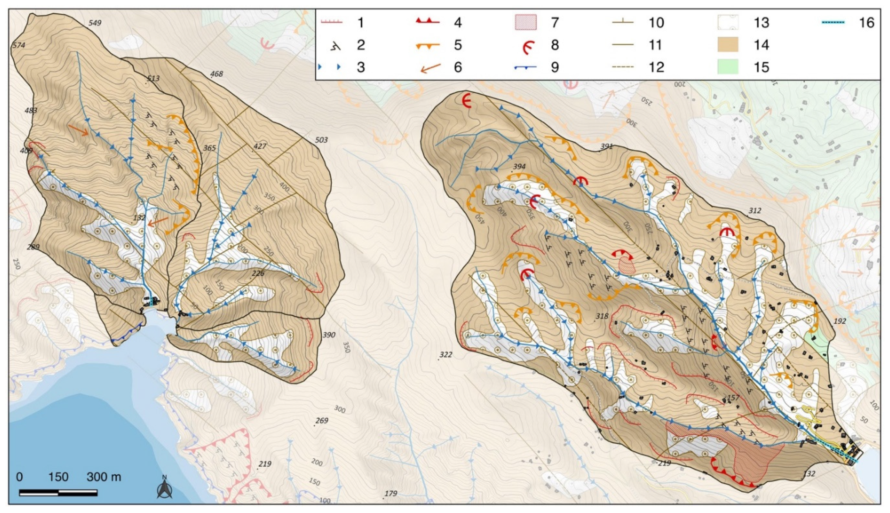
Catchments in the promontory share similar morphometric features: small extension and high slope gradients with the consequent high relief energy (Table 1). The study area includes five small catchments (Figure 2B) with mean slope gradient ranging from approximately 50% to 80% and a maximum altitude that reaches 604 m a.s.l. at a very short distance from the coastline. These features cause strong intensity in erosion, both diffuse and concentrated (Figure 3); many small landslides are present in catchment n. 5 but downcutting talweg is spread among all the studied catchments.
The presence of terraces in the territory is historical and produced important geomorphic modifications that resulted in changes to the vegetation and drove the early settlement evolution [8,23]. Terraces are an essential component of the landscape and, in some area, slopes have been totally modified. Large olive grove areas, in use or abandoned ones, are present in the promontory and in the studied catchments (Figure 2A,B) and, because of the high slope gradient, they all coincide with terraced areas. Many other terraces are diffusively spread in re-vegetated areas or in totally abandoned ones. The central part of the promontory is mainly covered by wood land, while the warm south facing slopes are dominated by Mediterranean scrub (Figure 2A,B).
2.2. Meteorological Settings
The Portofino promontory is characterized by a Mediterranean climate, Csa: hot-summer Mediterranean climate, sensu Koppen [54], with temperatures ranging between 21 and 27 °C in July, and mild winter with temperatures ranging from 5 and 11 °C in January. Rainy days are quite spread in every season with a higher concentration in fall: the mean annual rain is approximately 1300 mm and 350 mm in fall.
The peculiar morphology of the promontory causes strong local spatial variations in microclimate because of the altitude effect, variation in aspect of the slopes and the distance from the sea. Intense rain events are mainly related to the Genoa Gulf cyclogenesis (Genoa Low) [54] that triggers the main source of geo-hydrological hazard. The low pressure is generated by the incoming of Atlantic cold air masses of the Rodano valley that, impacting Corsica relief, are deviated to NE. Consequently, humid and cool winds are induced to move from SW directions toward N, to the Ligurian Gulf. Temperature contrast between humid and cold air masses with the warm sea surface and the interaction with the Liguria morphology, generate the Ligurian Sea stationary low pressure. The circulation generates intense rain precipitations, mainly between August and November, with events with high, short duration peaks that usually exceed 50 mm/h in less than 6 hours. The related ground effects are often severe with floods and spread shallow landslides that cause damage and, occasionally, even casualties [48,49,50,51]. The more frequent and widespread geo-hydrological hazards are debris/mud flows and flash floods, always involving exposed elements such buildings and infrastructures. In Table 2 are shown the more damaging events occurred on the Portofino promontory starting from the year 1900.
On 25 September 1915, the combination of flash floods and shallow landslides caused one of the more damaging events along the whole coastline between Genova and Chiavari [55]: buildings were destroyed in some small coastal plains and even casualties occurred. Precipitation reaching approximately 400 mm/3 hrs, triggered a large debris flow-type event along San Fruttuoso slopes that partially destroyed the ancient Abbey, generating the beach. Significant damage occurred even in the Paraggi bay area, after flooding and stream erosion.
Similar events happened on 4–5 October 1995 and on 25 January 1996 [13,56]: flooding in Santa Margherita Ligure and Rapallo and many debris/mud flows occurred causing widespread damage. The more important debris flow happened downward Le Gave (d in Figure 2A). Similar intense, critical and rapid events happened close to San Rocco village (a in Figure 2A) in 1961, 1964, 1995 and 2002 [13,49,52,56]. On 26 July 2014, in San Fruttuoso, a 120 mm/2 hrs event caused the collapse of some terraces and the subsequent mud/debris flow that reached the seaside moving along the ‘Fosso di San Fruttuoso’ creek, resulting in hard damage to touristic facilities during the full season.
Slow moving landslides are quite widespread and happen frequently on the promontory: some are large ancient reactivated landslides, but most involve stone walls terraced slopes. The more important occur both in the western and in the eastern side of the promontory.
2.3. Research Methodology
Terrace detection issues have been faced by many authors using various approaches [2,23,25,53]. Of particular concern are localities that have been abandoned for a long time, where field survey often fails to recognize terraces due to difficulties in accessing some areas and in the covering effect of uncontrolled re-vegetation. Then, thanks to the wide diffusion of LIDAR (Laser Imaging Detection and Ranging) data, some analytical methods have been developed to automatically detect and enhance the discernibility of a terraced slope [6,42,43,44,58,59,60,61,62]. The crucial aspect for every automatic detection methodology is data accuracy: good quality data allow the identification of terraces even in abandoned areas with uncontrolled vegetation, while poor quality data may induce errors, limit or even not allow correct identification.
Terraced surfaces in the studied area have been detected with both indirect and direct approaches: after remote sensing data analysis, a direct survey has been performed where possible to control and arrange the final results. For the indirect analysis, vector and raster data have been used within a GIS – Geographical Information System open source software (Quantum Gis 2.18). In Table 3, data used are shown: all the vector data and orthophotography of Portofino have been acquired by the local authority (Liguria Region), while LIDAR DTM (Digital Terrain Model) from Environmental Italian Minister. Google Earth images have been used for the high detail and for their recent acquisition; their analysis has been performed in parallel with the Portofino flight one, considering the different vegetation cover and always switching to the one that allowed the better terraces recognition.
The available LIDAR DTM is affected by a banding effect in N-S and E-W directions that is particularly intense in some zones. Many efforts have been spent in trying to filter data and reducing the banding effect, but no satisfying result has been obtained. This issue critically impacts the performance of semi-automatic detection techniques and then a combined approach has been followed, using several methodologies: the Sky View Factor computation, a new semi-automatic technique and the aerial orthophotography analysis. Finally, a direct survey has been applied where possible. Sky View Factor has been applied considering its suitability in recognizing terraces [63]; the computation has been performed in SAGA (System for Automated Geoscientific Analysis) open source GIS, using 16 sectors.
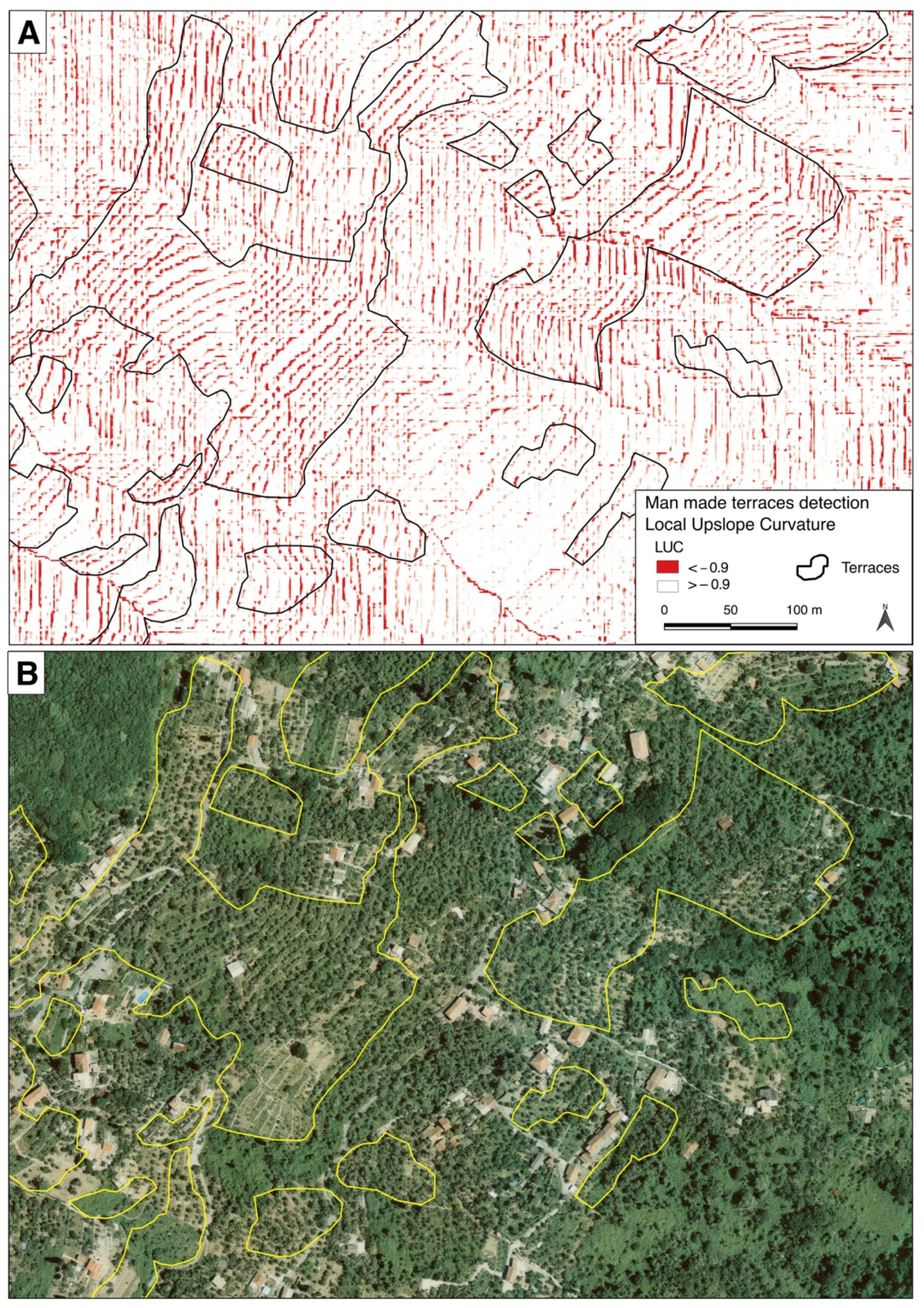
A new semi-automatic technique methodology for terrace identification is proposed, focusing on stone walls base detection (Figure 1). A routine developed in SAGA GIS called local upslope curvature (LUC) has been applied to the LIDAR DTM in order to identify the base as a high negative curvature zone, orthogonal to the highest gradient direction. LUC is defined as the mean of local curvatures of the directly neighboring upslope contributing cells in SAGA GIS documentation, where local curvature is defined as the sum of gradients to the neighboring cells; the higher negative values allow to evidence the stone walls basis, as evidenced in the test area (Figure 4).
The methodology has been tested in an area near the study area, shown with a dark blue square in Figure 2A, where a direct control has been done. The test area is almost completely terraced as it is even evidenced by the land use: olive grove and agricultural use is possible only with terracing due to the high slopes’ gradient. Results are presented in Figure 4, where LUC and identified terraces are compared to the aerial orthophotography from the Portofino survey 2004. The methodology allows to clearly identify some terraces, but others are avoided due to the noise in the original data that causes the N-S and E-W banding.
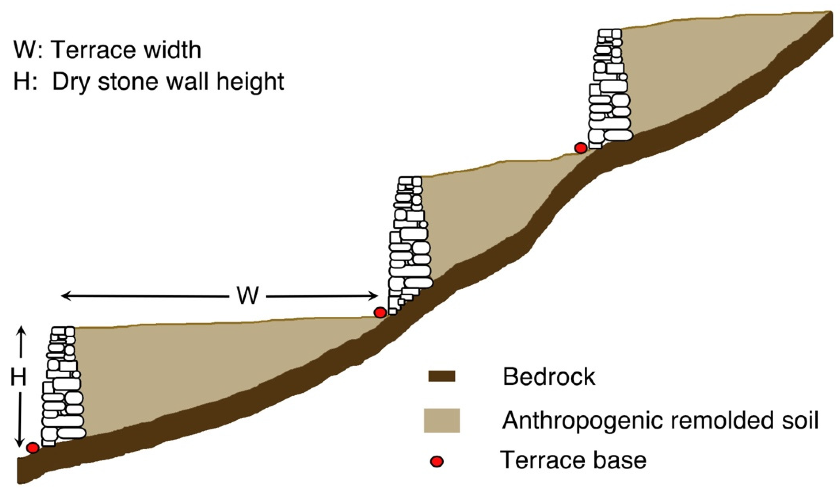
There is another limitation in the semi-automatic detection of terraces beside the DTM banding: resolution affects the possibility of detecting terraces below a specific width (Figure 1). The test area allows evaluating terraces with a width over approximately 3 m; under that value it is difficult, and a higher resolution would be needed. The direct survey allowed the identification of terraces 2 m wide that, probably, would need a 0.5 m DTM for the semi-automatic detection.
The integration between the LUC method and the aerial orthophotography analysis, using both the 2004 and 2018 flight, allows to reduce the errors and uncertainty induced by banding in the LIDAR DTM. These results have been combined to the ones obtained from the Sky View Factor computation through a union operation and getting to a final overall terrace identification.
3. Results
3.1. Terrace Identification
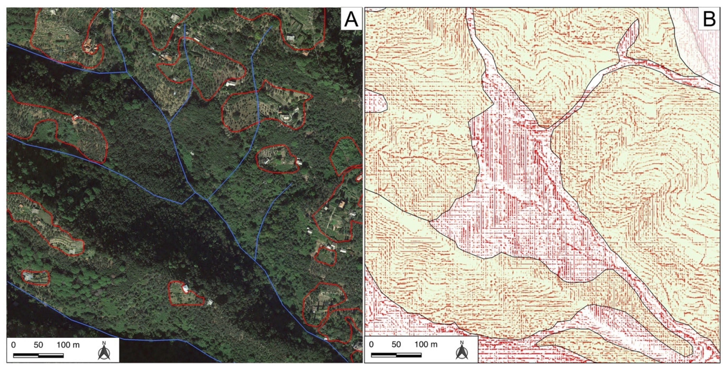
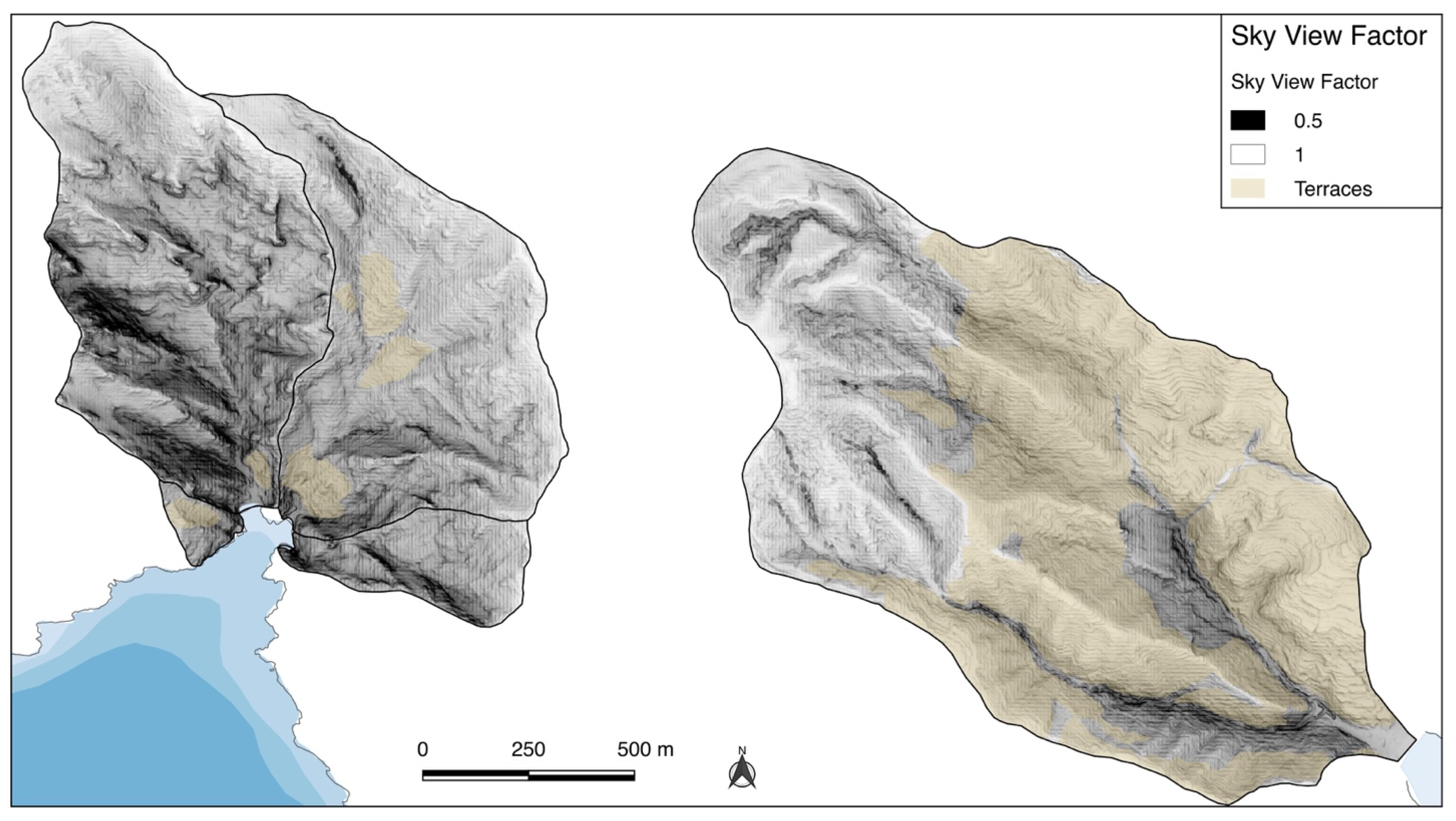
The combined results of the LUC methodology, Sky View Factor, orthophotography analysis and field survey facilitated detection of terraces in the study area: many terraces would have been impossible to recognize with only direct survey both for the impracticality of accessing some private properties and for the uncontrolled re-vegetation of the abandoned areas. In Figure 5 and Figure 6, the partial results for the dotted square area in Figure 2B are shown. Orthophotography analysis (Figure 5), despite the high resolution, allowed only a very partial recognition due to the dense vegetation, while LUC method, despite the banding effect, allowed a wider detection. Detected terraces through Sky View Factor (Figure 6) and LUC methodologies largely coincide but, in some cases, both failed in recognizing terraces revealed by the direct survey. This lack is probably due to the banding effect in LIDAR data and to the limitations of their spatial resolution.
In particular, the combination of the adopted methodologies let us recognize terraces in inaccessible areas and where vegetation is dense as LIDAR data have been acquired in late fall 2008 when the canopy effect was at its low. This result is of special importance in area 5 as terraces are largely abandoned in the lower part of the catchment and vegetation often avoid the direct detection.
The overall result for the five small catchments is shown in Figure 7 where, after a direct survey control, are highlighted the in use and maintained terraces; all the results are summarized in Table 4.
The area number 1, which is not a catchment but a slope draining directly to the sea, is largely occupied by terraces belonging to an historical olive grove that is protected by the regional Superintendence for the Landscape. The adopted technique and the direct survey allowed to precisely identify its boundary and the actual use condition. Currently, it is in total abandonment: vegetation has been partially substituted by scrub and erosion and partial collapse of stone walls highly threaten its intact state and existence. For these reasons, the indirect methodologies partially failed in detecting terraces that only the direct survey allowed. Its presence is related to the Abbey in San Fruttuoso (dated approximately 1000 a. C.), like all the terraces in catchments 2 and 3; then their origin is linked to the Abbey as many ancient documents testify their presence. The total abandonment of terraces dates back to the period after the WW II.
In catchment 2, the few terraces are completely concentrated in the lower part, close to the ancient Abbey, while in catchment 3 they are distributed along approximately 12.4% of the surface and are largely in abandonment. In catchment 4 no terraces have been detected.
Catchment 5 presents a large terraced surface, amounting approximately 58.6% of the total; even in this case terraces are mostly in abandonment. The maintained ones are prevalently in the southern aspect slopes. In the past and until 19th century, more than 30 mills where present in the catchment and trade and processing were highly active in this small area. Nowadays the catchment is part of the highly valuable Portofino promontory and only terraces close to some building are in good maintenance conditions.
The detected terraces only partially coincide with the presence of olive groves, in abandonment or not, and agricultural areas that are indicated in the land cover map of Figure 2B. Recently, some areas have been recovered, particularly in catchment 5 in the south aspect slopes in its central portion.
3.2. Terraces, Erosion and Ptential Element at Risk
The largely abandoned terraces in the studied areas represent a possible cause of hazard [12,20,34,37]: erosion and collapse of terraces may be an additional source area for debris, general instability and shallow landslides. Recently, many events of collapse involved terraced areas in the region in a similar context, due to high rain intensity phenomena: in 5 Terre (close to La Spezia—Figure 2A) in 2011, more than 300 small debris caused a total amount of approximately 100,000 m3 in a 5.4 km2 catchment [13,32,33] and in 2014 in Leivi, approximately 12 km east from the studied area (close to Chiavari—Figure 2A), debris moved from a terraced area, causing two casualties [40]. Another shallow landslide event happened in late November 2019, impacting a highway pier and causing its collapse close to Savona, in the wester Riviera at approximately 60 km west from the studied area.
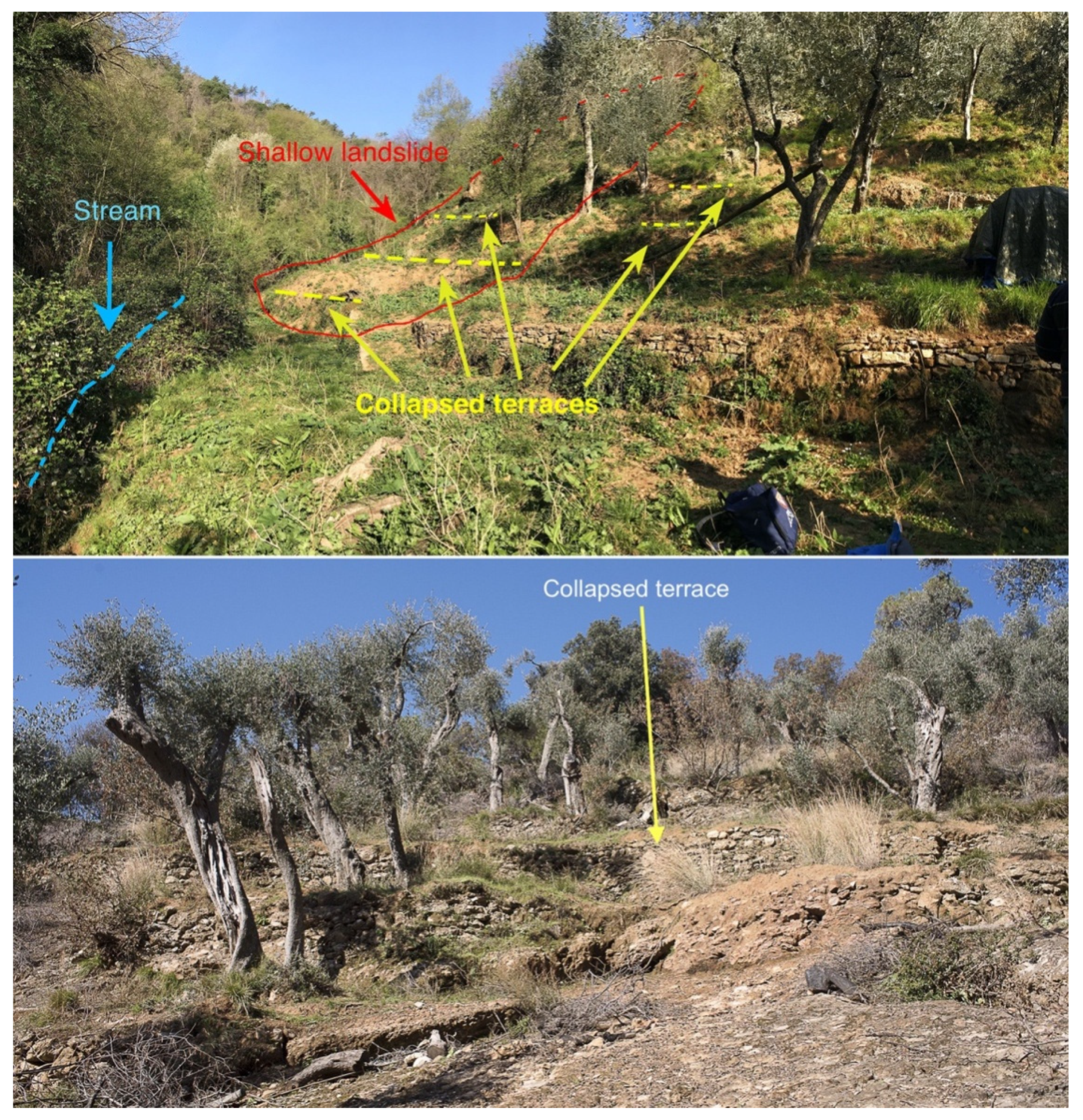
The direct survey allowed identification of stone walls instability and erosion: many processes are active due to the high relief energy (Figure 3) and their effect may combine with the possible instability of debris and sediments trapped into terraces. Some examples are shown in Figure 8 from catchments n. 5 and n. 3: in the former the possible debris could get into the stream and then run down quickly along the compluvium, increasing the solid transport. In the latter, terraces are directly on the rocky outcrop due to the high gradient and are partially collapsed; in this area, soil is present only in terraces.
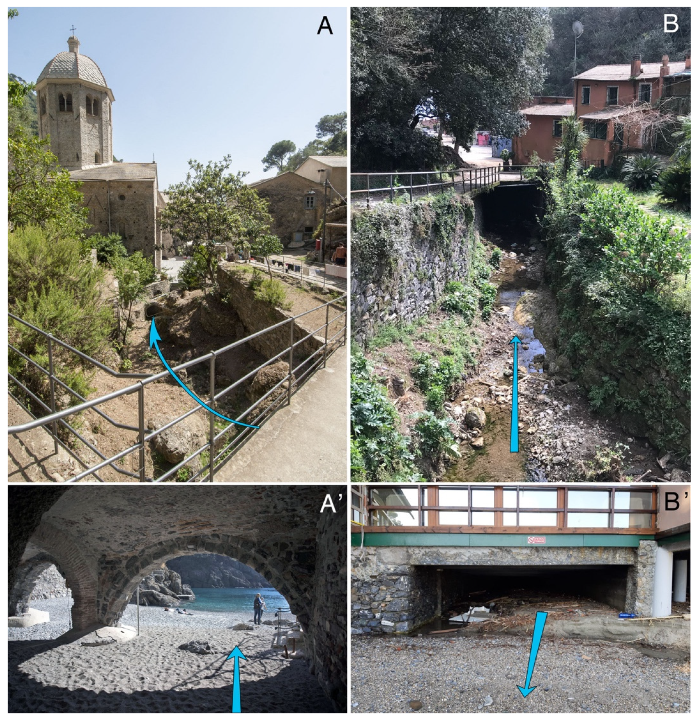
Then it is crucial to evaluate areas that may be a potential source of hazard and the eventual exposed elements. In the studied areas, despite the low degree of urbanization, various kinds of elements are present: the Cultural Heritage of the ancient San Fruttuoso Abbey in catchment 2 that is immediately downward a steep terraced area, residential buildings and tourism facilities. Besides, the stream in catchment 2 is culverted and passes under the Abbey (Figure 9A–A’): it is probably one of the older culverts ever detected. The damaging power of a possible debris moving from the slopes upward the culvert was shown during the flood in 1915 when the western part of the Abbey partially collapsed and the debris formed the beach.
At the mouth of catchment n. 3, some touristic facilities and buildings are exposed to the eventual debris caused by a sudden collapse of terraces in the upward slopes. Terraces are diffuse around the two compluvium even in the middle part of the catchment, then a relatively high volume of debris may impact the structures moving from high-gradient slopes.
In catchment n. 5, many private residential buildings may be impacted by debris/hyper-concentrated flow, but the most exposed elements are the culvert at the stream mouth (Figure 9B–B’) and all the buildings and road that lay on it. The culvert section drops down from the inlet to the outlet and it appears to be insufficient if large quantity of debris should move from the upward slopes. The possible saturation of the transport capacity of the culvert would cause water and debris to overflow, then damaging touristic facilities, private buildings and the road that runs along the coastline linking Portofino with Santa Margherita Ligure and with the highway. After the 2018 sea storm, the road partially collapsed and its interruption caused large economic loss in the area, resulting in approximately six months of work in order to be renovated.
4. Discussion
The importance of the accurate identification of terraced area is essential in evaluating the possible landscape evolution and processes that may result in hazard increase. It is crucial even for identifying the elements at risk: spatial relationships assessment between the possible instability areas and the exposed elements is fundamental for planning activity and to adopt appropriate mitigation interventions.
High slope gradient areas, like Portofino promontory, are characterized by low deposits, debris cover and soil accumulation: the high relief energy causes an intense erosion activity both concentrated and diffused, avoiding deposition. Terraces represent a relatively large mass of debris, soil and sediments immobilized along the slopes by human activity along the time [12]. Locally, in Portofino area, terraces may date back at the origin of the primitive settlement like the Abbey in San Fruttuoso, as testified by historical documents [8,23]. This anthropogenic immobilization needs a permanent maintenance activity to avoid the effect of erosion. Besides, soil and landscape, that is characterized by terraces, are unrenewable resources whose loss would impact even the local economy that is essentially based on tourism.
Terraces and associated soil and debris may represent source areas for shallow landslides [64] and fast developing processes like debris flow and hyper-concentrated flow that can be triggered by intense rain events [47,51]: several events happened in the Liguria region in the recent past. These processes may affect buildings, infrastructures and Cultural Heritage causing a high potential damaging effect on people and on the local economy. In the recent past, many events happened even in the Portofino promontory, particularly in the catchment n. 2, n. 3 and n. 4 of the studied area, due to the strong local effect of intense rain events, but more intense events happened recently along the coastline. Then it is important to evaluate what could be the consequence of such events in the study area.
The limited extension of the catchments and the strong slope gradient cause a direct relationship between the slopes and the coastline: time of concentration is approximately few minutes and debris/hyper-concentrated flow can reach high speed moving to the lower part of the catchment, where most of the hazard-exposed elements are concentrated. Then, the high speed of the eventual moving masses would result in high energy impacting structures and buildings that lay on the potential trajectories, like that which occurred during the 1915 event in San Fruttuoso with the partial collapse of the Abbey.
It must be underlined that, in case of intense rain events, the diffuse presence of dead trees on the ground, caused by the recent wind storms in 2016 and 2018, would be available as floating transport elements in the stream network, adding to the possible debris/hyper-concentrated flow. This moving mass, if it should reach the stream mouth in catchments n. 2 and n. 5, would impact the culverts easily saturating their transport capacities. The consequence would be the flooding of the surroundings and the possible impact of debris on buildings and touristic facilities; potential damage would involve the Abbey in catchment n. 2 and the road and buildings in catchment n. 5. Similar effects may happen in catchment 3, as in 2014: despite the lack of a culvert, some buildings are present at the stream mouth. The possible collapse of the terraced slope in catchment n. n. 1 would result in the definitive loss of an historical olive grove with a permanent damage for the landscape.
The combined detecting approach followed in the present research allowed recognition of abandoned stone walled terraces and those covered by uncontrolled vegetation that were not recognized before using traditional methodologies [23], in particular in catchment n. 5. The localized terraces only partially coincide with the olive grove and agricultural areas identified in the recent Land cover map in Figure 2B, as vast are the abandoned areas.
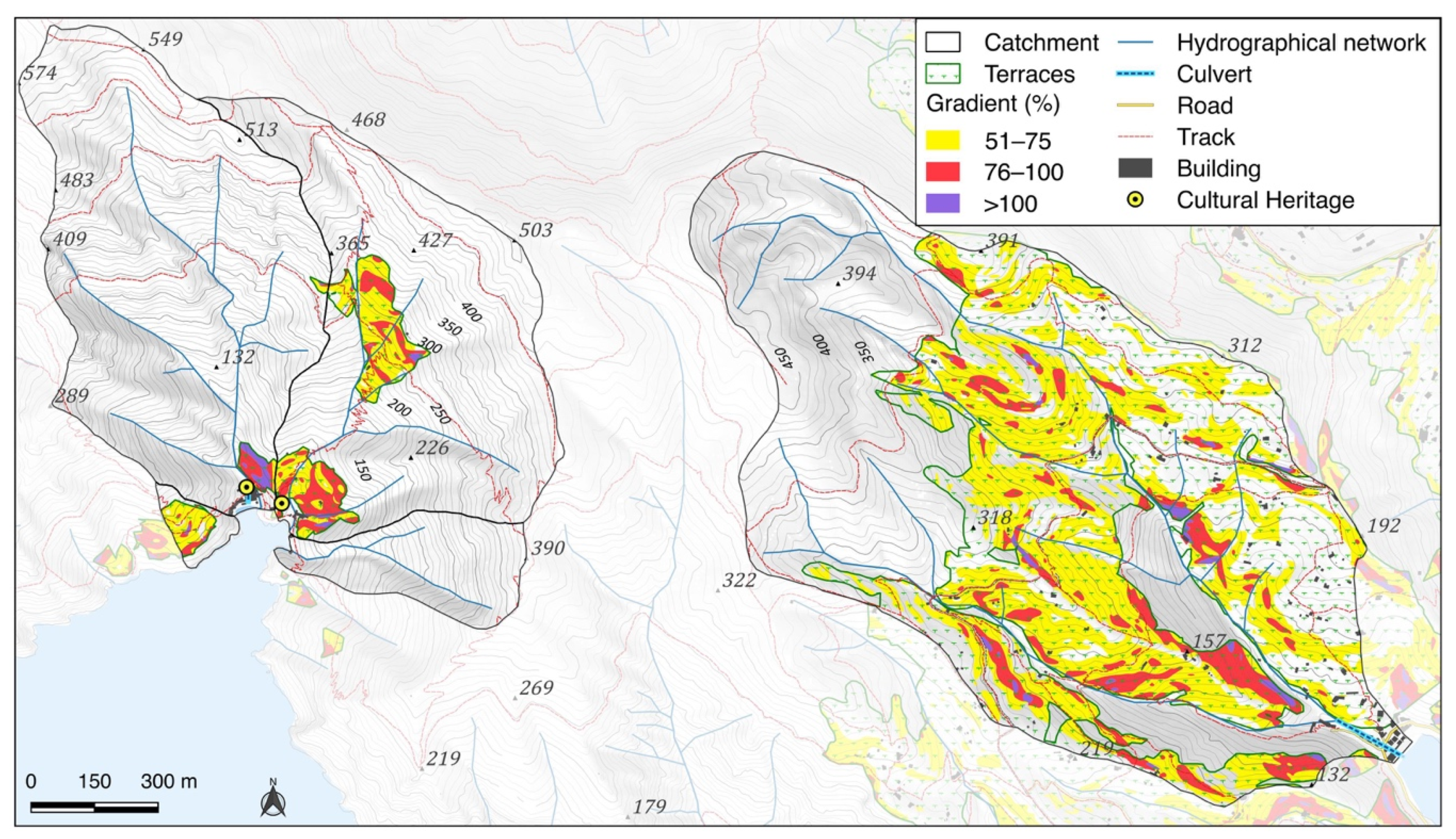
In order to prioritize the terraced areas in terms of a potential hazard source of debris/hyper-concentrated flow, a classification of slope gradient has been done (Figure 10). Several authors considered slope gradient [37] as a driving factor for instability processes: Brancucci and Paliaga [12] identified a slope gradient higher than approximately 60% for the increasing instability of stone wall terraces and similar values have been obtained considering shallow landslides involving terraces after the 5 Terre 2011 flash flood [33]. Comparable values were found by Cevasco et al. for the shallow landslides that occurred in 2014 in Leivi [40]. Some preliminary evaluation about recent similar events in the Liguria region could even suggest a lower threshold level of approximately 50% for shallow landslide triggering in case of fully saturated soil after intense and prolongated rainfall.
The three slope gradient classes in Figure 10 could be intended as a priority attention scale for terraces but all of them belong to the critical value over 50%. The further factors to be considered are the closeness to the hydrographical network as a connectivity factor and the local morphometry: hollow landforms tend to concentrate running water and then magnify the eventual destabilization of the cover that, in some areas, is essentially constituted by terraces.
While in catchment 1, terraces are on a slope belonging to the gradient class 51%–75% and hazards threaten only the terraced slope itself, in number 2, 3 and 5, the morphometric context and the relationship with the exposed elements appear more critical. In number 2, terraces belong to the two higher gradient classes and are close to the stream and to the Abbey. In number 3, terraces belong to the medium gradient classes but are spread in the catchment, in the higher, medium and lower portion and close to the hydrographical network: hollow landforms could contribute in inducing the activation of debris/hyper-concentrated flow that, considering the streams profile high gradient, could cause the moving masses to reach high speed with a consequent high impact energy on the buildings along the seaside. Catchment n. 5 is the largest of the studied ones and presents widespread terraces belonging to the three slope gradient classes; the higher are in the lower and medium portion. Many terraces belong to a hollow morphometry and are close to the streams, then both the critical factors are combined. In this case the culvert, which is more than 170 m long and whose section is approximately 5 m2 at the outlet, could be easily saturated in its transport capacity considering the possible dam effect of the joined floating and solid transportation.
Considering the active geomorphic processes in the area, which are driven by the high relief energy due to the high slope gradient, the possible instability related to the terraced areas could be adding to landslides, diffuse erosion and incision that affect particularly most of the catchment 5. Regarding land cover (Figure 2), the presence of forest tree on abandoned terraces in the central part and right hydrological side in catchment n. 5 could be a factor of reducing the potential instability, due to a better protection effect from the running water; on the contrary, the olive grove, shrubs and mixed vegetal cover may be considered as a worsening factor.
5. Conclusions
The identification of terraces in the study area has been performed with a combined technique trying to overcome two major issues: the difficult accessibility of some areas and the banding effect that disturbs the available LIDAR DTM. The combined use of direct survey and remote sensing data analysis allowed the identification of terraces and of the maintained ones. Then the spatial relationships with exposed elements were analyzed and combined with the geomorphological features of the studied areas.
The potential hazard related to possible debris/hyper-concentrated flow that can be triggered during intense rain event is great and involves elements like private buildings, tourism facilities, Cultural Heritage and a road. The geo-hydrologic hazard is a threat, both to the cultural integrity of the stone walled terraces and downslope locations to which they might be displaced during storm event. The potential damage could be high, considering the importance of tourism for the local economy and the eventual loss of unrenewable resources like landscape and soil in a high-value natural area. Besides, the ancient Abbey could be damaged as has previously occurred.
The assessment that emerges from the study could be used to plan a series of diffuse interventions aimed to reduce instability and stimulate recovery of abandoned terraces and maintenance in the in-use ones with proper techniques: preserving dry stone wall permeability and cleaning and maintaining the water draining system that was arranged when terraces were realized. Besides, particular attention must be paid to situations where possible debris/hyper-concentrated flow may impact directly buildings and allocate funds to stimulate recovery of terraces that are in the more critical areas and conditions. The difficulty of implementing adequate measures due to private properties must be underlined: direct public interventions are not possible but funding may be used, considering priority areas, only after agreement with private owners.
Another critical aspect that emerged from the study is the presence of culverts at the stream mouth of two catchments: in case of debris/hyper-concentrated flow, like the ones that occurred in the 5 Terre flash flood in 2011, the saturation of the transport capacity would be highly probable and the high energy would produce severe effects.
The study results suggest the need for a holistic approach to instability issues related to intense rain events: small catchments in mountainous areas by the sea react immediately to intense events and the relationships between the upper part of the catchment and the lower part, where most of the exposed elements lay, are direct. The effects of instability in the upper catchment may suddenly reproduce its effects in the lower catchment, and so it is essential to understand these strict links and prevent more critical situations.
Finally, similar situations may be found along the whole Liguria region and even in other similar contexts in Italy: the Campania coastline and Sicily in particular present widespread terraced areas in high-gradient slopes and often face intense rain events. In the Mediterranean, many areas share the same kinds of problems: the Balearic Islands in Spain, the Cote d’Azur in France and the Greek islands and coastline. A holistic approach and a proper evaluation of instability issues related to terraces could be similarly adopted to mitigate risk.
Further development of this research will be addressed to a new and better quality LIDAR survey, possibly with a higher resolution that would allow the identification of even terraces with a smaller width that have been detected through the direct investigation.
Author Contributions
Conceptualization, G.P.; methodology, G.P.; software, G.P.; validation, F.F., F.L. and L.T.; formal analysis, G.P.; investigation, F.F.; resources, F.L. and L.T.; data curation, G.P.; writing—original draft preparation, G.P. and F.F.; writing—review and editing, G.P. and J.V.D.G.; visualization, G.P.; supervision, F.L. and J.V.D.G.; project administration, L.T.; funding acquisition, F.L. and L.T. All authors have read and agreed to the published version of the manuscript.
Funding
This research is an outcome of RECONECT project (Regenerating ECOsystems with Nature-based solutions for hydro-meteorological risk rEduCTion). This project has received funding from the European Union’s Horizon 2020 Research and Innovation Programme under grant agreement No 776866.
Conflicts of Interest
The authors declare no conflict of interest.
References
- Healy, P.F.; Lambert, J.D.; Arnason, J.T.; Hebna, R.J. Caracol, Belize: Evidence of ancient Maya Agricultural Terraces. J. Field Archaeol. 1983, 10, 397–410. [Google Scholar]
- Price, S.; Nixon, L. Ancient Greek agricultural terraces: Evidence from texts and archaeological survey. Am. J. Archaeol. 2005, 109, 665–694. [Google Scholar] [CrossRef]
- Varotto, M. Towards the rediscovery of the “middle landscapes”. In Terraced Landscapes of the Alps; Atlas. Project ALPTER: Venezia, Marsilio, 2008. [Google Scholar]
- Agnoletti, M.; Cargnello, G.; Gardin, L.; Santoro, A.; Bazzoffi, P.; Sansone, L.; Pezza, L.; Belfiore, N. Traditional landscape and rural development: Comparative study in three terraced areas in northern, central and southern Italy to evaluate the efficacy of GAEC standard 4.4 of cross compliance. Ital. J. Agron. 2011, 6, 16. [Google Scholar] [CrossRef]
- Agnoletti, M.; Conti, L.; Frezza, L.; Santoro, A. Territorial Analysis of the Agricultural Terraced Landscapes of Tuscany (Italy): Preliminary Results. Sustainability 2015, 7, 4564–4581. [Google Scholar] [CrossRef] [Green Version]
- Tarolli, P.; Preti, F.; Romano, N. Terraced landscapes: From an old best practice to a potential hazard for soil degradation due to land abandonment. Anthropocene 2014, 6, 10–25. [Google Scholar] [CrossRef]
- UNESCO Intanglible Cultural Heritage List. Available online: https://ich.unesco.org/en/lists (accessed on 18 December 2019).
- Paliaga, G.; Giostrella, P.; Faccini, F. Terraced landscape as cultural and environmental heritage at risk: An example from Portofino Park (Italy). ANNALES Ser. Hist. Sociol. 2016, 26, 513–522. [Google Scholar] [CrossRef]
- Romero-Calcerrada, R.; Perry, G.L. The role of land abandonment in landscape dynamics in the SPA ‘Encinares del río Alberche y Cofio, Central Spain, 1984–1999. Landsc. Urban Plan. 2004, 66, 217–232. [Google Scholar] [CrossRef]
- Hammad, A.A.; Haugen, L.E.; Børresen, T. Effects of stonewalled terracing techniques on soil-water conservation and wheat production under Mediterranean conditions. Environ. Manag. 2004, 34, 701–710. [Google Scholar] [CrossRef]
- Arnaèz, J.; Lana-Renault, N.; Lasanta, T.; Ruiz Flaño, P.; Castroviejo, J. Effects of farming terraces on hydrological and geomorphological processes. A review. Catena 2015, 128, 122–134. [Google Scholar] [CrossRef] [Green Version]
- Brancucci, G.; Paliaga, G. The hazard assessment in a terraced landscape: The Liguria (Italy) case study in Interreg III Alpter project. In Geohazards–Technical, Economical and Social Risk Evaluation; Berkeley Electronics Press: Berkeley, CA, USA, 2006. [Google Scholar]
- Brandolini, P.; Cevasco, A.; Capolongo, D.; Pepe, G.; Lovergine, F.; Del Monte, M. Response of terraced slopes to a very intense rainfall event and relationships with land abandonment: A case study from cinque terre (Italy). Land Degrad. Dev. 2017, 29, 630–642. [Google Scholar] [CrossRef]
- Crosta, G.B.; Dal Negro, P.; Frattini, P. Soil slips and debris flows on terraced slopes. Nat. Hazards Earth Syst. Sci. 2003, 3, 31–42. [Google Scholar] [CrossRef] [Green Version]
- Lesschen, J.P.; Cammeraat, L.H.; Nieman, T. Erosion and terrace failure due to agricultural land abandonment in a semi-arid environment. Earth Surf. Process. Landf. J. Br. Geomorph. Res. Group 2008, 33, 1574–1584. [Google Scholar] [CrossRef]
- Schilirò, L.; Cevasco, A.; Esposito, C.; Scarascia Mugnozza, G. Shallow landslide initiation on terraced slopes: Inferences from a physically based approach. Geomat. Nat. Hazard. Risk 2018, 9, 295–324. [Google Scholar] [CrossRef] [Green Version]
- Schönbrodt-Stitt, S.; Behrens, T.; Schmidt, K.; Shi, X.; Scholten, T. Degradation of cultivated bench terraces in the Three Gorges Area: Field mapping and data mining. Ecol. Indic. 2013, 34, 478–493. [Google Scholar] [CrossRef]
- Preti, F.; Guastini, E.; Penna, D.; Dani, A.; Cassiani, G.; Boaga, J.; Deiana, R.; Romano, N.; Nasta, P.; Palladino, M. Conceptualization of water flow pathways in agricultural terraced landscapes. Land Degrad. Dev. 2018, 29, 651–662. [Google Scholar] [CrossRef]
- García-Ruiz, J.M.; Lana-Renault, N. Hydrological and erosive consequences of farmland abandonment in Europe, with special reference to the Mediterranean region–A review. Agric. Ecosyst. Environ. 2011, 140, 317–338. [Google Scholar] [CrossRef]
- Rogger, M.; Agnoletti, M.; Alaoui, A.; Bathurst, J.C.; Bodner, G.; Borga, M.; Chaplot, V.; Gallart, F.; Glatzel, G.; Hall, J.; et al. Land use change impacts on floods at the catchment scale: Challenges and opportunities for future research. Water Resour. Res. 2017, 53, 5209–5219. [Google Scholar] [CrossRef] [Green Version]
- Chow, T.L.; Rees, H.W.; Daigle, J.L. Effectiveness of terraces/grassed waterway systems for soil and water conservation: A field evaluation. J. Soil Water Conserv. 1999, 54, 577–583. [Google Scholar]
- Bellin, N.; van Wesemael, B.; Meerkerk, A.; Vanacker, V.; Barbera, G.G. Abandonment of soil and water conservation structures in Mediterranean ecosystems: A case study from south east Spain. Catena 2009, 76, 114–121. [Google Scholar] [CrossRef]
- Van der Sluis, T.; Kizos, T.; Pedroli, B. Landscape change in Mediterranean farmlands: Impacts of land abandonment on cultivation terraces in Portofino (Italy) and Lesvos (Greece). J. Landsc. Ecol. 2014, 7, 23–44. [Google Scholar] [CrossRef] [Green Version]
- Rosenbaum, M.S.; McMillan, A.A.; Powell, J.H.; Cooper, A.H.; Culshaw, M.G.; Northmore, K.J. Classification of artificial (man-made) ground. Eng. Geol. 2003, 69, 399–409. [Google Scholar] [CrossRef] [Green Version]
- Bevan, A.; Conolly, J. Terraced fields and Mediterranean landscape structure: An analytical case study from Antikythera, Greece. Ecol. Model. 2011, 222, 1303–1314. [Google Scholar] [CrossRef]
- Agnoletti, M.; Conti, L.; Frezza, L.; Monti, M.; Santoro, A. Features analysis of dry stone walls of Tuscany (Italy). Sustainability 2015, 7, 13887–13903. [Google Scholar] [CrossRef] [Green Version]
- Modica, G.; Praticò, S.; Di Fazio, S. Abandonment of traditional terraced landscape: A change detection approach (a case study in Costa Viola, Calabria, Italy). Land Degrad. Dev. 2017, 28, 2608–2622. [Google Scholar] [CrossRef]
- Di Fazio, S.; Modica, G. Historic rural landscapes: Sustainable planning strategies and action criteria. The Italian experience in the global and European context. Sustainability 2018, 10, 3834. [Google Scholar] [CrossRef] [Green Version]
- Brunori, E.; Salvati, L.; Antogiovanni, A.; Biasi, R. Worrying about ‘Vertical Landscapes’: Terraced olive groves and ecosystem services in Marginal Land in Central Italy. Sustainability 2018, 10, 1164. [Google Scholar] [CrossRef] [Green Version]
- Gallart, F.; Llorens, P.; Latron, J. Studying the role of old agricultural terraces on runoff generation in a small Mediterranean mountainous basin. J. Hydrol. 1994, 159, 291–303. [Google Scholar] [CrossRef]
- Pijl, A.; Tosoni, M.; Roder, G.; Sofia, G.; Tarolli, P. Design of Terrace Drainage Networks Using UAV-Based High-Resolution Topographic Data. Water 2019, 11, 814. [Google Scholar] [CrossRef] [Green Version]
- Agnoletti, M.; Errico, A.; Santoro, A.; Dani, A.; Preti, F. Terraced Landscapes and Hydrogeological Risk. Effects of Land Abandonment in Cinque Terre (Italy) during Severe Rainfall Events. Sustainability 2019, 11, 235. [Google Scholar] [CrossRef] [Green Version]
- Agnoletti, M.; Emanueli, F.; Errico, A.; Maggiari, G.; Santoro, A.; Preti, F. Terracing and hydrogeological risk. A study of the environmental disaster of 25 October 2011 in Cinque Terre. In EGU General Assembly Conference Abstracts; Issuu, Inc.: Copenhagen, Denmark, 2015; Volume 17. [Google Scholar]
- Dunjó, G.; Pardini, G.; Gispert, M. Land use change effects on abandoned terraced soils in a Mediterranean catchment, NE Spain. Catena 2003, 52, 23–37. [Google Scholar] [CrossRef]
- Giordan, D.; Cignetti, M.; Baldo, M.; Godone, D. Relationship between man-made environment and slope stability: The case of 2014 rainfall events in the terraced landscape of the Liguria region (northwestern Italy). Geomat. Nat. Hazard. Risk 2017, 8, 1833–1852. [Google Scholar] [CrossRef] [Green Version]
- Kizos, T.; Dalaka, A.; Petanidou, T. Farmers’ attitudes and landscape change: Evidence from the abandonment of terraced cultivations on Lesvos, Greece. Agric. Hum. Values 2010, 27, 199–212. [Google Scholar] [CrossRef]
- Koulouri, M.; Giourga, C. Land abandonment and slope gradient as key factors of soil erosion in Mediterranean terraced lands. Catena 2007, 69, 274–281. [Google Scholar] [CrossRef]
- De Graff, J.V.; Canuti, P. Using isopleth mapping to evaluate landslide activity in relation to agricultural practices. Bull. Int. Assoc. Eng. Geol. 1988, 38, 61–71. [Google Scholar] [CrossRef]
- Camera, C.A.; Apuani, T.; Masetti, M. Mechanisms of failure on terraced slopes: The Valtellina case (northern Italy). Landslides 2012, 11, 43–54. [Google Scholar] [CrossRef]
- Cevasco, A.; Pepe, G.; D’Amato Avanzi, G.A.; Giannecchini, R. Preliminary analysis of the November 10, 2014 rainstorm and related landslides in the lower Lavagna Valley (Eastern Liguria). Ital. J. Eng. Geol. Env. 2017, 1, 5–15. [Google Scholar]
- Zalasiewicz, J.; Waters, C.N.; Summerhayes, C.P.; Wolfe, A.P.; Barnosky, A.D.; Cearreta, A.; Crutzeng, P.; Ellish, E.; Fairchild, I.J.; Gałuszka, A.; et al. The Working Group on the Anthropocene: Summary of evidence and interim recommendations. Anthropocene 2017, 19, 55–60. [Google Scholar] [CrossRef]
- Godone, D.; Giordan, D.; Baldo, M. Rapid mapping application of vegetated terraces based on high resolution airborne LiDAR. Geomat. Nat. Hazard. Risk 2018, 9, 970–985. [Google Scholar] [CrossRef] [Green Version]
- Diaz-Varela, R.; Zarco-Tejada, P.J.; Angileri, V.; Loudjani, P. Automatic identification of agricultural terraces through object-oriented analysis of very high resolution dsms and multispectral imagery obtained from an unmanned aerial vehicle. J. Environ. Manag. 2014, 134, 117–126. [Google Scholar] [CrossRef]
- Detection of Old Agricultural Terraces in Steep, Vegetated Terrain Using Airborne Lidar: Case Studies from Hong Kong. Available online: https://pdfs.semanticscholar.org/ff70/27865b8b709c123b51f28e998147213bccae.pdf (accessed on 5 February 2020).
- Faccini, F.; Gabellieri, N.; Paliaga, G.; Piana, P.; Angelini, S.; Coratza, P. Geoheritage map of the Portofino Natural Park (Italy). J. Maps 2018, 14, 87–96. [Google Scholar] [CrossRef]
- Coratza, P.; Vandelli, V.; Fiorentini, L.; Paliaga, G.; Faccini, F. Bridging Terrestrial and Marine Geoheritage: Assessing Geosites in Portofino Natural Park (Italy). Water 2019, 11, 2112. [Google Scholar] [CrossRef] [Green Version]
- Acquaotta, F.; Faccini, F.; Fratianni, S.; Paliaga, G.; Sacchini, A.; Vilìmek, V. Increased flash flooding in Genoa Metropolitan Area: A combination of climate changes and soil consumption? Meteorol. Atmos. Phys. 2018, 131, 1–12. [Google Scholar] [CrossRef]
- Brandolini, P.; Faccini, F.; Robbiano, A.; Terranova, R. Geomorphological hazard and monitoring activity along the western rocky coast of the Portofino Promontory (Italy). Quat. Int. 2007, 171, 131–142. [Google Scholar] [CrossRef]
- Faccini, F.; Luino, F.; Paliaga, G.; Sacchini, A.; Turconi, L.; de Jong, C. Role of rainfall intensity and urban sprawl in the 2014 flash flood in Genoa City, Bisagno catchment (Liguria, Italy). Appl. Geogr. 2018, 98, 224–241. [Google Scholar] [CrossRef]
- Paliaga, G.; Faccini, F.; Luino, F.; Turconi, L. A spatial multicriteria prioritizing approach for geo-hydrological risk mitigation planning in small and densely urbanized Mediterranean basins. Nat. Hazards Earth Syst. Sci. 2019, 19, 53–69. [Google Scholar] [CrossRef] [Green Version]
- Paliaga, G.; Donadio, C.; Bernardi, M.; Faccini, F. High-Resolution Lightning Detection and Possible Relationship with Rainfall Events over the Central Mediterranean Area. Remote Sens. 2019, 11, 1601. [Google Scholar] [CrossRef] [Green Version]
- Faccini, F.; Piccazzo, M.; Robbiano, A.; Roccati, A. Applied Geomorphological Map of the Portofino municipal territory (Italy). J. Maps 2008, 4, 451–462. [Google Scholar] [CrossRef]
- Brancucci, G.; Paliaga, G. Geomorphic characterization of the main drainage basins of maritime Liguria (Italy)-preliminary results. Geogr. Fis. Din. Quat. 2005, VII, 59–67. [Google Scholar]
- Sacchini, A.; Ferraris, F.; Faccini, F.; Firpo, M. Environmental climatic maps of Liguria. J. Maps 2012, 8, 199–207. [Google Scholar] [CrossRef] [Green Version]
- Faccini, F.; Piccazzo, M.; Robbiano, A. Natural hazards in San Fruttuoso of Camogli (Portofino Park, Italy): A case study of a debris flow in a coastal environment. Boll. della Soc. Geol. Ital. 2009, 128, 641–654. [Google Scholar]
- The AVI Project of CNR-GNDCI. Available online: http://avi.gndci.cnr.it/ (accessed on 18 December 2019).
- Turconi, L.; Faccini, F.; Marchese, A.; Paliaga, G.; Casazza, M.; Vojinovic, Z.; Luino, F. Implementation of Nature-Based Solutions for hydro-meteorological risk reduction in small Mediterranean catchments: The case of Portofino Natural Regional Park. Sustainability 2020, in press. [Google Scholar] [CrossRef] [Green Version]
- Sofia, G.; Bailly, J.S.; Chehata, N.; Tarolli, P.; Levavasseur, F. Comparison of pleiades and LiDAR digital elevation models for terraces detection in farmlands. IEEE J. Sel. Top. Appl. Earth Observations Remote Sens. 2016, 9, 1567–1576. [Google Scholar] [CrossRef] [Green Version]
- Tarolli, P.; Sofia, G.; Calligaro, S.; Prosdocimi, M.; Preti, F.; Dalla Fontana, G. Vineyards in Terraced Landscapes: New Opportunities from Lidar Data. Land Degrad. Dev. 2015, 26, 92–102. [Google Scholar] [CrossRef]
- Tucci, G.; Parisi, E.I.; Castelli, G.; Errico, A.; Corongiu, M.; Sona, G.; Viviani, E.; Bresci, E.; Preti, F. Multi-Sensor UAV Application for Thermal Analysis on a Dry-Stone Terraced Vineyard in Rural Tuscany Landscape. ISPRS Int. J. Geo-Inf. 2019, 8, 87. [Google Scholar] [CrossRef] [Green Version]
- Tarolli, P.; Cavalli, M.; Masin, R. High-resolution morphologic characterization of conservation agriculture. Catena 2019, 172, 846–856. [Google Scholar] [CrossRef]
- Challis, K. Airborne laser altimetry in alluviated landscapes. Archaeol. Prospect. 2006, 13, 103–127. [Google Scholar] [CrossRef]
- Kokalj, Ž.; Hesse, R. Airborne Laser Scanning Raster Data Visualization: A Guide to Good Practice; Založba ZRC: Slovenia, Balkans, 2017; Volume 14, pp. 1–90. [Google Scholar]
- Gariano, S.L.; Iovine, G.G.R.; Brunetti, M.T.; Peruccacci, S.; Luciani, S.; Bartolini, D.; Palladino, M.R.; Vessia, G.; Viero, A.; Vennari, C.; et al. Populating a catalogue of rainfall events that triggered shallow landslides in Italy. Ital. Geol. Soc. 2012, 21, 396–398. [Google Scholar]
Figure 1.
Schematic profile of a terraced slope.

Figure 2.
(A) Portofino promontory geographical sketch; dark blue box: stone wall bases detection test area (Figure 4); (a) San Rocco; (b) San Nicolò; (c) Cervara; (d) Le Gave. (B) The studied areas numbered 1 to 5 and Corine Land Cover 2018 tipology: 1122: Discontinuous built-up areas with family houses with gardens; 223: Olive groves; 2231: Abandoned Olive groves; 243: Agricultural areas; 3111: Broad-leaved forests with continuous canopy, not on mire; 312: Coniferous forests; 3112: Broad-leaved forests with continuous canopy on mire; 313: Mixed forests; 323: Sclerophyllous vegetation; 324: Transitional woodland-scrub; 332: Bare rocks; 333: Sparsely vegetated areas. The dotted box shows the area in the following Figures 5 and 6.

Figure 3.
Geological/geomorphological sketch of the studied catchments. (1) Fluvial erosion scarp; (2) surface affected by rill/inter-rill erosion; (3) incising riverbed; (4) landslide scarp, active; (5) landslide scarp, inactive; (6) isolated fallen/toppled block; (7) landslide, active; (8) shallow landslide, soil slip; (9) erosional coastal scarp; (10) bedding; (11) certain fault; (12) presumed fault; (13) debris cover; (14) Conglomerates with sandstone layers; (15) marly limestones, clayey shales, siltstone and marls; (16) culvert.

Figure 4.
Terrace identification test. (A): stone wall basis identification through Local Upslope Curvature (LUC) after proper enhancement. (B): aerial orthophotography of the area with, in yellow, the terraced areas identified through LUC calculation.
Figure 4.
Terrace identification test. (A): stone wall basis identification through Local Upslope Curvature (LUC) after proper enhancement. (B): aerial orthophotography of the area with, in yellow, the terraced areas identified through LUC calculation.

Figure 5.
A detail of the studied catchments, the dotted box of Figure 2. (A) terrace identification on orthophotography. (B) in light green terrace identification with LUC method.
Figure 5.
A detail of the studied catchments, the dotted box of Figure 2. (A) terrace identification on orthophotography. (B) in light green terrace identification with LUC method.

Figure 6.
The detected terraces after Sky View Factor computation.

Figure 7.
Terrace identification in the studied catchments after the application of the integrated methodology and evidence of the in use/maintained ones.
Figure 7.
Terrace identification in the studied catchments after the application of the integrated methodology and evidence of the in use/maintained ones.

Figure 8.
Examples of partially collapsed terraces: up, in the medium catchment n. 5 and down, on conglomerate substratum in the catchment n. 3.
Figure 8.
Examples of partially collapsed terraces: up, in the medium catchment n. 5 and down, on conglomerate substratum in the catchment n. 3.

Figure 9.
Culvert inlets (A,B) and outlets (A’,B’) at the stream mouth in catchment n. 2 for A–A’ and catchment n. 5 for B–B’.
Figure 9.
Culvert inlets (A,B) and outlets (A’,B’) at the stream mouth in catchment n. 2 for A–A’ and catchment n. 5 for B–B’.

Figure 10.
Terraces on higher class slope gradients are highlighted: they correspond to the higher hazard of instability. The main exposed elements are buildings, Cultural Heritage, culverts and roads.
Figure 10.
Terraces on higher class slope gradients are highlighted: they correspond to the higher hazard of instability. The main exposed elements are buildings, Cultural Heritage, culverts and roads.


Table 1.
Main morphometric features of the five studied catchments (see Figure 2B for location).
Table 1.
Main morphometric features of the five studied catchments (see Figure 2B for location).
| Catchment | Surface (km2) | Mean Altitude (m) | Max Altitude (m) | Mean Gradient (%) |
|---|---|---|---|---|
| 1 | 0.02 | 60 | 158 | 73.8 |
| 2 | 0.56 | 312 | 604 | 78.2 |
| 3 | 0.48 | 320 | 531 | 67.9 |
| 4 | 0.10 | 219 | 390 | 79.6 |
| 5 | 1.48 | 249 | 478 | 51.4 |
Table 2.
The main flood, debris flow and landslide events from 1900 to the present day (modified from Brandolini et al. [48], Faccini et al. [55], Turconi et al. [57] in press). Rain gauge: Santa Margherita Ligure (SML), Camogli (CAM), MPOR (Monte di Portofino).
| Day/Month/Year | Daily Rainfall | Rain Gauge | Overview |
|---|---|---|---|
| 12 October 1911 | - | - | Severe floods in Santa Margherita Ligure (San Siro stream) and Camogli (Gentile stream) cities, widespread debris/mud flows on Mount of Portofino |
| 25 September 1915 | 440 mm | SML | One of the most disastrous floods ever recorded, 1 victim in Camogli, floods in Santa Margherita Ligure (San Siro stream), Camogli (Gentile stream) cities. Widespread landslides debris flows (San Fruttuoso catchments) |
| 15 October 1953 | 170 mm | SML | Flood in Santa Margherita Ligure city, overflowing of the San Siro and Magistrato streams, severe damage and shallow landslides triggered on the whole area |
| 18 November 1959 | 90 mm | SML | Flood in Santa Margherita Ligure city, overflowing of the San Siro stream, damage in the historical centre, shallow landslides widespread on Mount of Portofino |
| 06 September 1961 | 180 mm | SML | Flood in Santa Margherita Ligure city, overflowing of the San Siro stream, damage in the old city, shallow landslides widespread on the Mount of Portofino, mainly on the W slope |
| 28 October 1961 | 250 mm | MPOR | Flood in Santa Margherita Ligure city, overflowing of the San Siro stream, widespread shallow landslides and mud/debris flows on the Mount of Portofino |
| 1 December 1961 | 95 mm * | - | Debris flows on the W slope of the Mount of Portofino (Castellaro) |
| 18 April 1963 | 90 mm | CAM | Debris flows on the W slope of the Mount of Portofino (San Rocco, Mortola) |
| 04 December 1963 | 150 mm | SML | Flood in Santa Margherita Ligure city, overflowing of the San Siro stream, and on Portofino (Fondaco stream), shallow landslides on the whole area |
| 30 March 1964 | 70 mm | CAM | Debris flows and landslides on the W slope of the Mount of Portofino (San Rocco), road interruption for some villages |
| 28 December 1964 | 30 mm | SML | Debris flows and landslides on the W slope of the Mount of Portofino |
| 16 October 1987 | 100 mm | SML | Landslides on the E slope of the Mount of Portofino (Gave) |
| 27 September 1992 | 85 mm | CAM | Widespread shallow landslides and debris flow on the Mont of Portofino |
| 05 October 1995 | 250 mm * | - | Last flooding event in Santa Margherita Ligure city, overflowing of the San Siro and Magistrato streams, shallow landslides all over the Mount |
| 25 January 1996 | 110 mm * | - | Debris/mudflows on the E slope of the Mount (Gave), road interruption |
| 06 November 2000 | 90 mm | CAM | Shallow landslides all over the Mount, interrupted road to Portofino |
| 24 November 2002 | 90 mm | CAM | Debris flows widespread on the Mount, in particular on the W slope |
| 26 July 2014 | 70 mm | MPOR | Mud flows along the San Fruttuoso stream, damages to residential and tourist facilities |
| 25 October 2016 | 65 mm | MPOR | Landslide on the slope behind the E hamlet of San Fruttuoso, evacuate some houses |
* Data reconstructed indirectly.
Table 3.
Vector and raster data used.
| Name | Source | Type | Scale/Pixel | Date |
|---|---|---|---|---|
| Corine land cover | Regione Liguria | Vector | 1:10000 | 2018 |
| Catchment | Regione Liguria | Vector | 1:10000 | 2019 |
| Hydrographical network | Regione Liguria | Vector | 1:10000 | 2019 |
| Footpath | Regione Liguria | Vector | 1:25000 | 2019 |
| Roads | Regione Liguria | Vector | 1:5000 | 2007 |
| Contour levels | Regione Liguria | Vector | 1:5000 | 2007 |
| Slope gradient | Regione Liguria | Vector | 1:10000 | 2016 |
| LIDAR DTM | Environmental Italian Minister | Raster | 1 m | 2008 |
| Orthophotography | Regione Liguria | Raster | 0.15 m | 2004 |
| Orthophotography | Google Earth SPOT Image | Raster | 2.5 m | 2018 |
Note: SPOT Satellite Puor l’Observation de la Terre: remote sensing satellite constellation.
Table 4.
Terraced surface and the in use/maintained percentage for the studied catchments.
| Catchment | Terraced Surface | Terraces in Use (%) | |
|---|---|---|---|
| (m2) | (%) | ||
| 1 | 7300 | 35.7 | 0 |
| 2 | 10,270 | 1.8 | 17.1 |
| 3 | 59,630 | 12.4 | 7.5 |
| 4 | 0 | 0 | 0.0 |
| 5 | 870,050 | 58.6 | 16.6 |
© 2020 by the authors. Licensee MDPI, Basel, Switzerland. This article is an open access article distributed under the terms and conditions of the Creative Commons Attribution (CC BY) license (http://creativecommons.org/licenses/by/4.0/).
Share and Cite
MDPI and ACS Style
Paliaga, G.; Luino, F.; Turconi, L.; De Graff, J.V.; Faccini, F. Terraced Landscapes on Portofino Promontory (Italy): Identification, Geo-Hydrological Hazard and Management. Water 2020, 12, 435. https://doi.org/10.3390/w12020435
AMA Style
Paliaga G, Luino F, Turconi L, De Graff JV, Faccini F. Terraced Landscapes on Portofino Promontory (Italy): Identification, Geo-Hydrological Hazard and Management. Water. 2020; 12(2):435. https://doi.org/10.3390/w12020435
Chicago/Turabian StylePaliaga, Guido, Fabio Luino, Laura Turconi, Jerome V. De Graff, and Francesco Faccini. 2020. "Terraced Landscapes on Portofino Promontory (Italy): Identification, Geo-Hydrological Hazard and Management" Water 12, no. 2: 435. https://doi.org/10.3390/w12020435
Note that from the first issue of 2016, this journal uses article numbers instead of page numbers. See further details here.