Correlations of Stormwater Runoff and Quality: Urban Pavement and Property Value by Land Use at the Parcel Level in a Small Sized American City

Faculty of Innovation and Design, City University of Macau, Macau 999078, China
Water 2019, 11(11), 2369; https://doi.org/10.3390/w11112369
Submission received: 26 September 2019
/
Revised: 9 November 2019
/
Accepted: 11 November 2019
/
Published: 12 November 2019
(This article belongs to the Section Urban Water Management)
Abstract
:As the urban environment keeps growing, stormwater management programs have been adopted to address unregulated nonpoint runoff and pollutants across the world. Extensive studies on stormwater runoff and quality at smaller spatial scales exist, but are rare at larger spatial scales. Using the City of Corvallis, Oregon, a small sized American city, as a test-bed, this study estimates urban stormwater runoff and quality by zoning, which specifies land uses, and by parcel, which defines land ownership using the Integrated Valuation of Ecosystem Services and Tradeoffs (InVEST) model and high resolution land use and land cover data. The correlations between stormwater runoff volume, stormwater quality, parcel land cover sizes, and values are then analyzed and visualized in RStudio. The results indicate that stormwater runoff and quality are determined by complex biophysical processes, with strong correlations between urban spatial sizes and property values for some land uses being observed. The research results provide suggestions for low impact development applications for different land uses, and the findings in this research can be used to suggest stormwater management policy for various land uses in small sized cities.
1. Introduction
Urbanized areas are often covered by man-made impervious hard surfaces such as building roofs, paved roads, sidewalks, and parking lots, as well as pervious surfaces such as natural vegetation, bare land, or water [1,2]. Extensive studies have shown that stormwater runoff often occurs during precipitation when the land does not allow water to soak into the ground, and with the increase of impervious hard surfaces, the volume of urban stormwater runoff has increased significantly [3]. When the stormwater flows over impervious surfaces, it accumulates contaminants and sediment that impact water quality drastically [4,5]. However, how stormwater runoff quantity and quality, land pavement, and property values are correlated on the land parcel level of different land uses is unclear [6,7,8].
Small and medium sized cities have been growing increasingly in the United States, driven by the potential to stimulate inclusive economic developments that bridge the urban-rural divide [9]. As self-standing municipalities outside major urban agglomerations, small cities play an important role in protecting natural environments [10,11,12]. In many large cities in the United States, storm pipes are integrated with sanitary sewers and connected to treatment plants where runoff is treated during precipitation events; however, stormwater is usually discharged directly into natural rivers and storms in small cities due to the lack of funds and facilities [13]. In light of these points, small cites need more diverse and comprehensive stormwater management strategies and policy to prevent nonpoint source pollution [14]. Corvallis, OR, was ranked as the third best small city to live in the U.S. in 2018 by livability [15]; however, the stormwater quality has deteriorated over time, and it does not meet the water quality standards established by the U.S. EPA (U.S. Environment Protection Agency) Clean Water Act [16]. The City of Corvallis has its own zoning designation, which specifies land uses such as commercial, residential, or industrial, and land parcel data define ownership with detailed property attributes, such as parcel size, building size, and market and assessed property value. The city also has detailed data of pervious land area and impervious land area (building footprint, road and driveway, sidewalk and path, parking lot), all in geographical information system (GIS) formats.
Using Corvallis as the case study, this research estimates its stormwater runoff quantity and quality by the well-known Integrated Valuation of Ecosystem Services and Tradeoffs (InVEST) water yield and pollutant export models. Modelling results are used to quantify their correlations with land pavement sizes and property values for residential, industrial, and commercial land uses classified from the zoning map at the land parcel level. InVEST was developed and calibrated in the Willamette River area within which the city of Corvallis is located [17] and has been applied well in the other coastal areas in Western North America in previous studies [18,19]. Utilizing the high resolution land use and land cover data on the parcel level provided by the city [20], this study chose Corvallis to take full advantage of the model. The research results aim to analyze: (i) what are the spatial factors (different land cover sizes) and value factors (property values) that need to be considered for stormwater management regulation in different land use parcels; (ii) to identify where to apply low impact development techniques to manage stormwater in different land uses parcels.
Urban stormwater runoff is heavily influenced by urban impervious surfaces and drainage systems in a watershed [21]. The change of natural lands into urban built-up areas in a watershed entails the removal of vegetation, alteration of soil characteristics, and creation of impervious surfaces, as well as interference of stream networks [22]. These changes are the leading causes for high runoff and peak discharges [23,24], which have been associated with many environmental problems, for example the destruction of aquatic habitats [25], alteration of hydrology [26], and increased incidents of flooding [27]. Specifically, Hao et al. (2015) showed that from 1986 to 2013, stream flow increased by 58% and land cover changes into impervious surface contributed more than 80% of the stream flow in a southern China watershed [28]. Lepeska (2016) demonstrated that buildings, roads, and parking lots contributed 40%, 31%, and 25% to the total urban runoff, respectively, in a watershed dominated by man-made land areas [29]. Schneider et al. (2012) demonstrated that urban sprawl with various impervious surfaces decreased the city’s ability to regulate flooding, and the residential area expansion resulted in 15–48% more urban runoff [30]. Wu et al. (2013) quantified the impacts of impervious surface and climate change on stream ecosystems and found that an impervious surface increase from 5.2% to 17.1% led to a large increase in peak discharge, flashiness, and runoff ratio to 49.5%, 39.3%, and 73.9%, respectively [31].
Urban development with vast impervious surfaces not only contributes to more stormwater runoff, but also degrades stormwater quality. In an investigation of the relationship between impervious surfaces and water samples collected in the City of Lubbock, TX, Heintzman et al. (2015) concluded that impervious pavement percentage is positively related to polycyclic aromatic hydrocarbons and suggested that in urban stormwater management, streams surrounded by more pervious covers and buffers should have fewer pollutants in the water [32]. In addition, Hogan and Walbridge (2007) found a significantly nonlinear correlation between phosphorus concentration and impervious surface percentage [33]. Ramirez et al. (2014) analyzed land cover variables with iron concentrations in stormwater in Puerto Rico and found significant linear regressions among chemical concentration, impervious surface, building density, road density, and pipe density [34].
Studies on urban stormwater have been performed across various disciplinary at various spatial levels [35]. However, research at the urban zoning and land parcel level is limited, mainly due to data availability and modelling complexity [36]. As a result, these studies draw attention mainly from government agencies, non-profit groups, or scientific communities, but not from individual owners whose land development decisions/actions at specific locations physically alter the environment’s quality [37,38]. Research on environmental quality dynamics (gains or losses) at the urban land use and parcel level is rare, and policies to influence parcel level urban development by individual owners are yet to be developed [39]. Moreover, most of these studies were conducted with urban impervious surface data derived from remote sensing images with few urban land use categories at a regional watershed scale [40]. Remote sensing is a relatively inexpensive and constructive method for reconstructing a base map in the absence of detailed land survey methods, but conditions under the urban tree canopy cannot be detected accurately. The variability of nonpoint urban water quality runoff with respect to different land use procedures poses challenges in making an effective stormwater management plan [8]. Furthermore, private landowners typically make land development decisions not necessarily for the public-good from the regional perspective, but in the owner’s private interest at the parcel level and in the forms of building, road, sidewalks, or parking lots, all of which are impervious surfaces [41,42]. More than 500 cities and counties in the U.S. have stormwater utilities, 60% of which raise revenues through property taxes paid into their general funds for stormwater management [43]. There exists a debate over the equality of the way to fund stormwater management from property taxes because of the claim that the cost of stormwater service to individual properties bears no relationship to the assessed value of the property [44]. Therefore, in this research, we estimate stormwater runoff and quality and explore their correlations with land pavement sizes and property values at the parcel level for major zoning categories. The aim of this research is to provide insights into the urbanization process to enhance public land use planning control and to ensure sound private land development at the parcel ownership level for different land uses. The paper is organized as follows: following the Introduction in Section 1, Section 2 specifies the methods and modelling process; Section 3 provides the results and analysis; and Section 4 summarizes the research and points out the research limitations.
2. Methods and Modelling Process
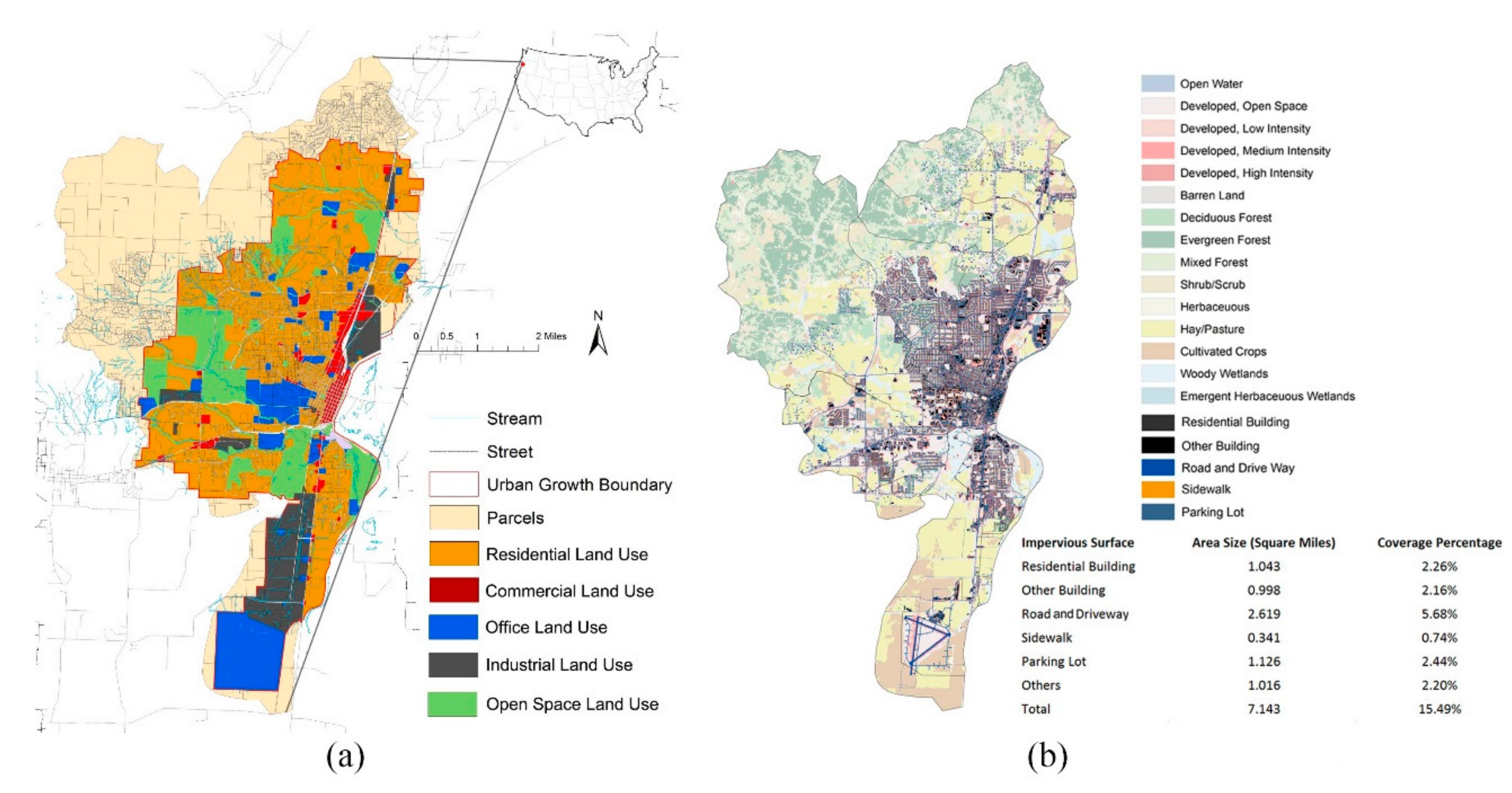
The City of Corvallis is located in the middle of the Willamette Valley in the State of Oregon. It ranked 3rd in the 2018 Top Best Small Cities to live for its beautiful natural environments, urban green infrastructure, employment opportunities, education, and medical services [15]. However, the Willamette River was ranked as the fifth most endangered river in 2019, and the stormwater pollution discharged into the Willamette River has been identified as one of the most critical and urgent issues by the Oregon Department of Environmental Quality [20]. Corvallis has a total area of 120 square kilometers, and the population grew from 55,522 in 2014 to 58,641 in 2018 with an average growth of 1.4%, which is faster than the average population growth in Oregon (0.89%) [9]. The urban parcels for residential, commercial, industrial, office, and open space land occupy 77%, 1%, 7%, 3%, and 12%, respectively (Figure 1a). The amount of total nitrogen and phosphorus contained in the urban stormwater does not meet the minimum standard established by the U.S. EPA, and the pollutants commonly observed in stormwater are nitrogen and phosphorus [16]. The impervious surface of buildings, roads and driveways, sidewalks, parking lots, and others (barren land and lands under construction) occupies 4.42%, 5.68%, 0.74%, 2.44%, and 2.20% of the total city land, respectively (Figure 1b).
2.1. Stormwater Runoff Yield Modelling
The InVEST model and its associated biophysical dataset were developed and calibrated by the Natural Capital Project in the Willamette Valley area within which Corvallis is located [17] and has been applied successfully in the other coastal areas in Western North America in previous studies [18,45,46]. This research uses the stormwater runoff yield and purification models and the biophysical data built in InVEST at 1 m × 1 m pixel resolution and combines the results at the parcel level. The land uses within Corvallis’s city limits are considered mainly as commercial, industrial, and residential uses based on the city’s urban zoning classifications. Based on the data from the City’s Planning Division, urban land surface is divided into impervious surfaces made up of buildings and paved roads, driveways, sidewalks, and parking lots and pervious green surfaces composed of grasses and trees.
InVEST runs Models (1)–(5) on raster GIS data for stormwater runoff yield calculation based on the interaction of precipitation, evapotranspiration, inflow through land cover, soil, and vegetation for each pixel x. Y(x) denotes the annual stormwater runoff yield. AET(x), P(x), and PET(x) denote the actual evapotranspiration, precipitation, and potential evapotranspiration, respectively. w(x) is a non-physical and empirical parameter with the natural climatic-soil properties. AWC(x) denotes the volumetric plant available water content in soil. Z is the seasonality factor determined by local hydrological features and the empirical precipitation pattern. ET0(x) is the reference evapotranspiration. Kc(lx) is the vegetation evapotranspiration coefficient and is largely determined by the vegetative characteristics associated with the land cover. Kc(lx) adjusts the ET0(x) values to the crop or vegetation type. Kc(lx) for built-up areas can be set to where f is the fraction of impervious covers in the area [47].
Y(x) = (1 − AET(x)/P(x)) × P(x)
AET(x)/P(x) = 1 + PET(x)/P(x) − (1 + (PET(x)/P(x))w)1/w
w(x) = Z × AWC(x)/P(x) + 1.25
PET(x) = Kc(lx) × ET0(x)
Kc(lx) = 0.1 × f + 0.6 × (1 − f)
For each pixel x, Equation (1) is to generate annual stormwater runoff yield. Equation (2) estimates the ratio of actual evapotranspiration vs. precipitation. Equation (3) shows that the non-physical parameter, which is capped to a value of 5 according to Donohue et al. (2012). Equation (4) indicates that potential evapotranspiration is positively related to the vegetation evapotranspiration and the reference evapotranspiration in each land cover category. In the built-up area, Equation (5) specifies the vegetation evapotranspiration in urban conditions by the percentage of impervious surface [48].
2.2. Stormwater Purification
In the stormwater quality quantification Models (6)–(8), ALVx is the adjusted pollution loading value for pixel x; POLx is the standard pollutant loading coefficient based on the land use and land cover; HSSx is the hydrologic sensitivity score, which is estimated by Ix as the runoff index and Iw as the mean runoff index in the watershed of interest. Once per pixel pollution loads are generated, the amount of downstream pixel retention can be calculated as surface runoff carrying the pollutant toward the stream. The model routes water down using runoff flow paths determined by elevation difference analysis and allows each pixel downstream from a polluting pixel to retain pollutants based on the land cover. By following the pollutant load and retention of each pixel along all the way downstream to a water body, the model also tracks how much pollutant reaches the stream.
ALVx = HSSx × POLx
HSSx = Ix/Iw
Gx = 1 − Ex
Table 1 describes how the pollution retention and export removal along the routing and hydraulic routing are calculated. Retx is the amount of pollution retention in each pixel. Ex is the pollution filtering value (removal efficient) of the pixel determined by its land use and land cover type. Gx is the pollution export coefficient of the pixel. Expx is the total amount of pollution flowing out of each pixel [47].
Compared with previous studies using remote sensing data to examine ecological indicators, another advantage of this research is that the canopy coverages on both impervious surface and pervious surface are considered to calculate urban stormwater runoff and quality through adjusting the sample biophysical table obtained from the Natural Capital Project Dataset [49] (see Table 2). For example, based on the sample data, the evapotranspiration coefficient Kc(lx) for a road surface is 0.1, and Kc(lx) for an urban canopy is 1. According to the City’s Urban Forestry Management Plan [50] and previous research sample data [51], the urban canopy coverage on a street is estimated at 15%; therefore, the adjusted Kc(lx) for a road is 0.235 (0.1 × 85% + 1 × 15%).
2.3. Research Framework and Data Processing
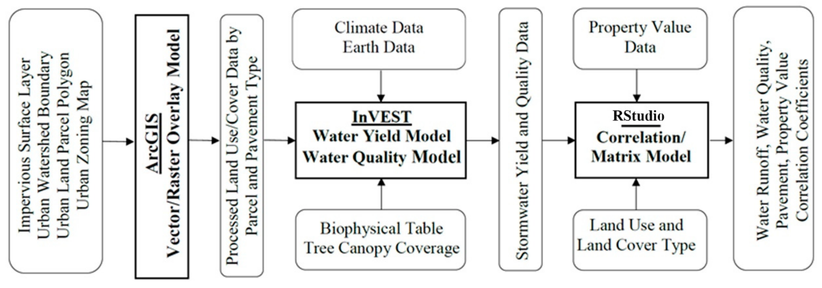
InVEST’s stormwater runoff yield and quality models require good raster land use and land cover (LULC) data (1 m × 1 m), which are compiled from various sources including impervious surface layers, watershed boundaries, land parcels, and zoning boundaries from the City of Corvallis’s GIS database [20]. These are processed with GIS toolboxes, especially vector/raster conversion, overlays, and summary functions. This LULC with zoning classifications is joined with climate, earth, and modified biophysical tables as inputs to the stormwater runoff and quality models, whose outputs are joined with property values and land cover sizes at the parcel level into RStudio for Pearson correlation analyses and result visualization. The modelling process is show in Figure 2, in which boxes with round corners are either data input or output and right-angle boxes are models in GIS, InVEST, or RStudio. Note that output from one upstream model can be used as input for downstream model, and the research focuses on the comparison of the correlation coefficients’ difference to improve the analysis accuracy.
According to the modelling process, climate, geographic, planning, and biophysical data comprise the four kinds of databases needed in this research. The InVEST sample dataset provide some needed biophysical data for the area of interests. The biophysical attributes in InVEST are adjusted with the consideration of the urban canopy coverage on parking lots, streets, driveways, grass, and along the sidewalk. The urban planning vector database from the City of Corvallis provides the locations and sizes of zonings, parcels, impervious pavements, building footprints, others (grass), and urban trees [20]. Table 3 lists out the data used in the modelling process.
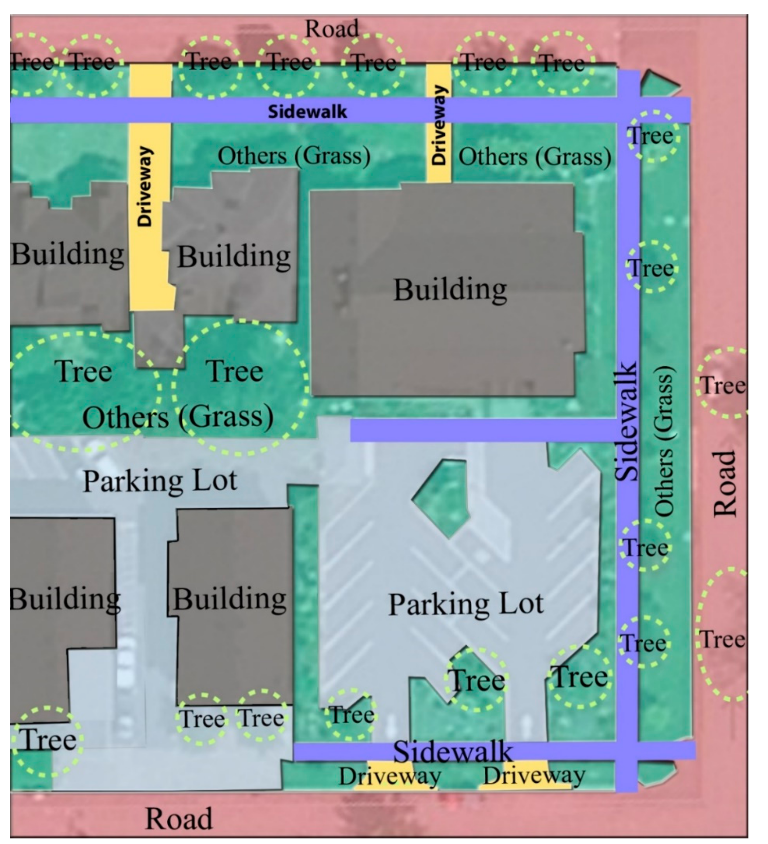
The land parcel and zoning data contain 13,875 urban parcels for commercial, residential, and industrial land uses within the city limit. The city’s tax lot database provides property value attributes, including land value (for the land only), assessed value (by mass appraisal), market value (by transaction), and improved value (for the building or structure on the parcel) [20]. The impervious surface data are provided by the city’s planning department. This dataset shows that 15.49% of the city land is covered by either impervious pavements or buildings [20]. Spatial joins in GIS were used to classify impervious surfaces into parcels. A detailed sample of the final urban land use and land cover processed for this research is shown in Figure 3.
3. Results and Analysis
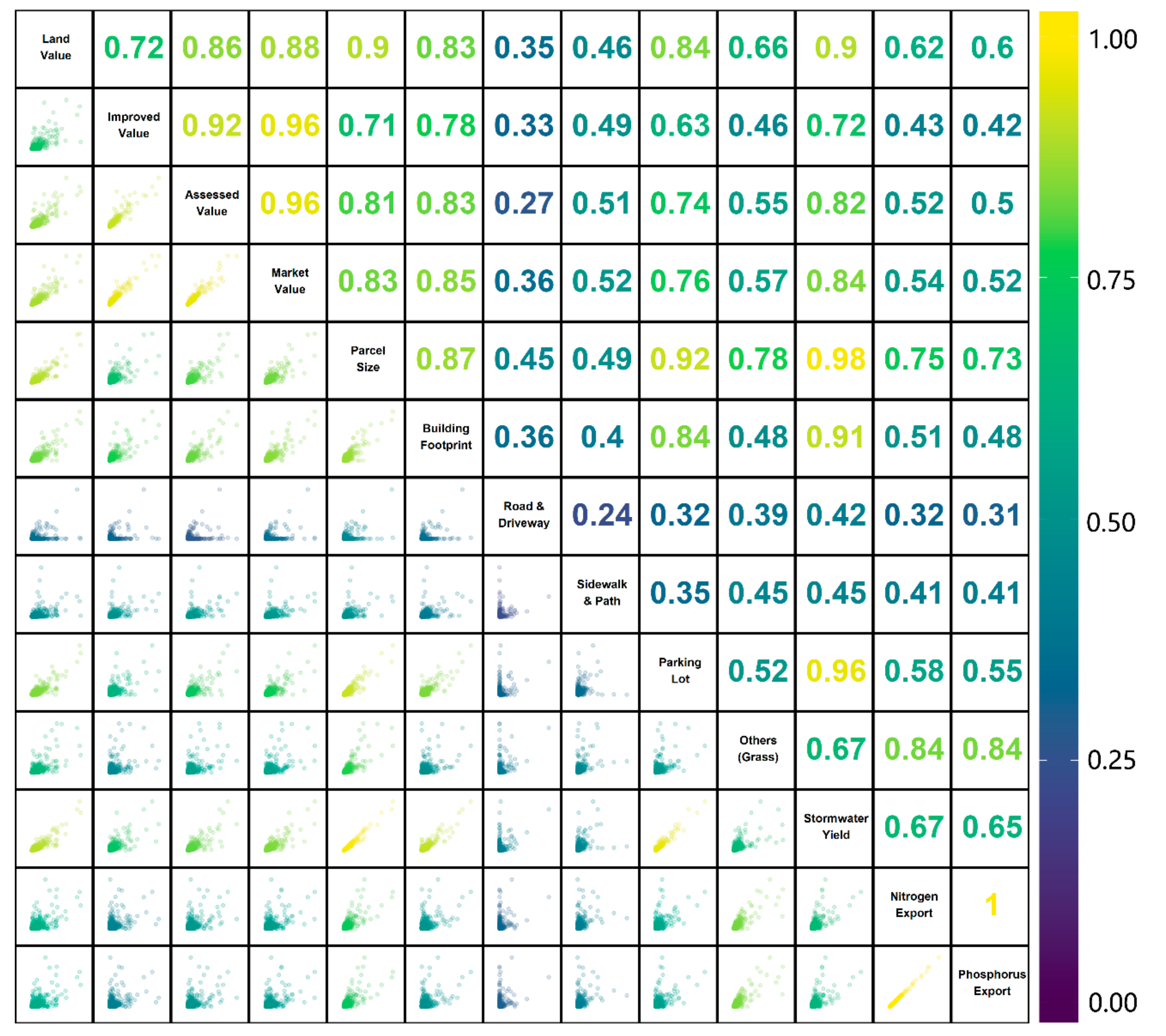
Compared with other models to assess land use planning’s impacts on stormwater yield and quality, InVEST is more suitable in a situation in which the underlying ecological processes and data are well understood [56]. This study took advantage of this by describing the modelling process in the area of research interest and obtaining the required data from publicly available data to facilitate wide-spread use. The limitation of InVEST includes the requirement of the knowledge of GIS and local data. This study overcame this limitation by overlaying the local data (city planning data) on the regional data (geographic data) using spatial operation tools in ArcGIS Map. Then, the research analyzed the Pearson correlations among the economic variables (labelled land value, assessed value, improved value, and market value), spatial variables (impervious pavement (labelled parking lot, road and driveway, building footprint, sidewalk and path), pervious green cover (labelled others for land covers with grasses)), ecological variables (stormwater runoff volume (labelled stormwater yield), and stormwater quality (labelled nitrogen export, and phosphorus export)) for parcel level commercial, industrial, and commercial land uses in RStudio. The results are visually summarized in scatterplots in Figure 4, Figure 5, Figure 6, Figure 7, Figure 8 and Figure 9 with correlation coefficients labelled with colors ranging from purple, as lower coefficients, to orange, as higher coefficients.
3.1. Scatterplot Matrix for Commercial Land Use
The correlations for all the commercial parcels are shown in Figure 4. The four economic variables had significant linear correlations among them, except for the one between land value and improved value. Land value correlated most with parcel size with R = 0.899, while improved value correlated most with building footprint or with R = 0.777. Among the spatial variables, parcel size was correlated well with the sizes of the main impervious surface building footprint and pervious surface land grass. This confirmed that parcel-based analyses are needed to make or evaluate planning policies to improve regional environmental qualities [57,58]. Among the ecological variables, nitrogen export was highly correlated with phosphorus export. Stormwater yield volume was highly correlated with land value, building footprint, and parking lot sizes, but not with sidewalk and path and road and driveway sizes. This could be explained by the urban canopy’s role in retaining water and higher tree coverage percentages on sidewalks and streets [59]. The coefficient between stormwater yield volume and land value was as high as 0.900, which indicates the land value could be considered to be a factor in setting up the stormwater utility fee in commercial parcels. The stormwater yield volume was strongly correlated with the parking lot size. This recommends identifying parking lots as priority sites for low impact development in commercial land uses. The nitrogen and phosphorus exports were both highly correlated with others, which could be explained by the fact that although the grass soil had the ability to filter out pollution from the stormwater [60], private urban land parcels with grasses are sometimes significant non-point sources of nitrogen and phosphorus potentially due to the use of fertilizers and the nitrogen and phosphorus generated by the grass surface itself flowing into the stormwater that was originally relatively clear [61]. This indicates that urban grass field is an important component of the urban ecosystem, but the location of the grass field needs to be analyzed to perform effective environmental spatial planning. It is suggested that urban lawn should be planned close to the upstream watershed with pollution sources, so the amount of pollution retention by urban grass is more than its pollution generation. Management such as reducing fertilization rates according to temperature and seasons is needed in maintenance practice to increase the efficiency of fertilization and reduce nitrogen or phosphorus accumulation [62]. Environmentally friendly landscape management is also recommended, including thoughtful planning and design, routine soil analysis, appropriate native plants that require less water and fertilizer, and fewer pesticide applications [63].
3.2. Scatterplot Matrix for Industrial Land Use
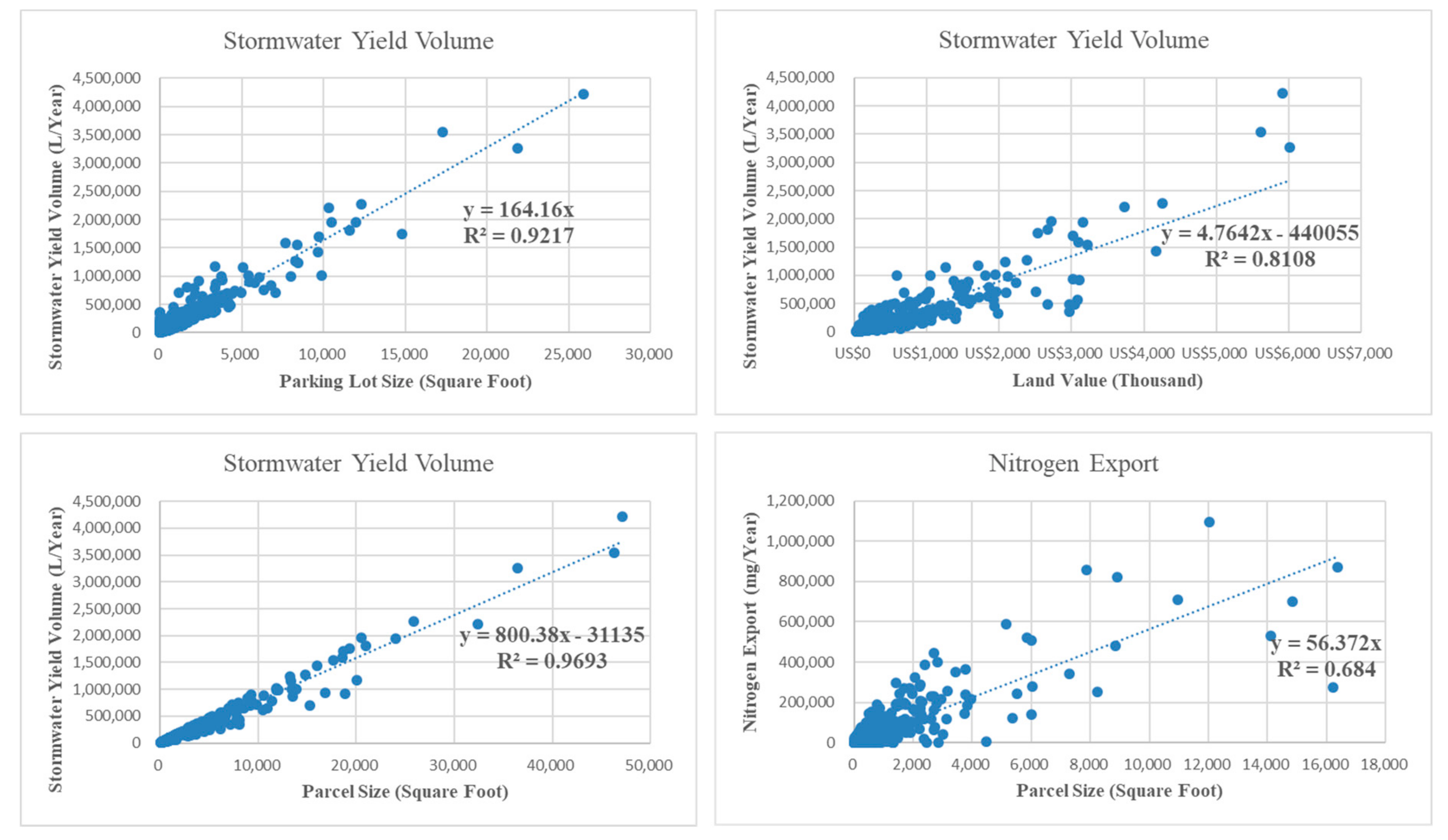
Storm water management is crucial on industrial lands due to the potential range and amount of pollutants that could flow into the urban runoff receiving natural water body [64]. For industrial parcels in Figure 6, the stormwater yield volume is still correlated with parcel size and land value with R = 0.981 and 0.836, respectively. This suggests that the stormwater utility fee tailored to an individual site could be regulated based on the parcel size or the land value as well. Furthermore, the stormwater volume was related to the parking lot size with the highest coefficient, which suggests adding more perviousness in the parking space to manage stormwater. There exists a high correlation between stormwater yield volume and nutrient exports with R > 0.700, indicating that more urban runoff carries out more nutrients from industrial parcels. Additionally, stormwater management techniques that reduce stormwater quantity are also effective at improving stormwater quality, for example in cost effective water sensitive planning in industry parks (WSP) that controls urban runoff and minimizes the negative impacts of stormwater [65].
3.3. Scatterplot Matrix for Residential Land Use
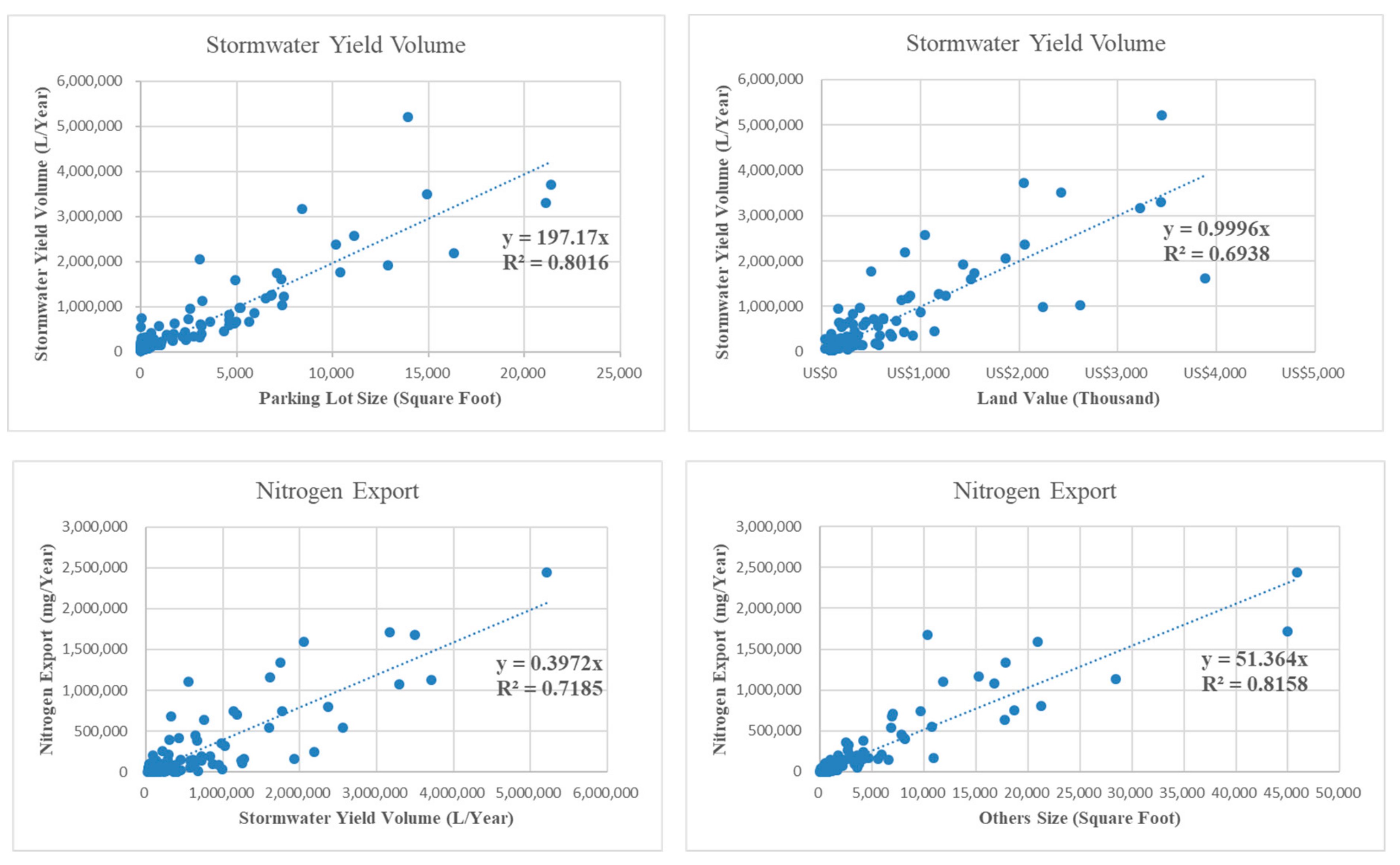
The correlation matrix for residential parcels is shown in Figure 8. Among the spatial variables, stormwater yield volume was related with the building footprint (roof) size most strongly, which suggests extensive green roof utilization in single family houses and extensive green roof utilization in apartments could efficiently reduce stormwater yield [19]. The correlation between stormwater was both with the parcel size and the land value, but the correlation coefficient with the parcel size was much higher. Furthermore, the amounts of nitrogen and phosphorus exports were correlated with the parcel size, and their relationship with property values was not clear. This implies regulating the stormwater utility fee according to the size of the parcel rather than the property value in residential parcels. Due to household actions and pet ownership [66], urban grass is a predominate source for watershed nitrogen and phosphorus input in residential parcels as well. It is suggested to maintain a dense cover of turf grass not only to reduce surface runoff volume, but also to retain nutrients [67].
In summary, through the correlation analysis, it was found that stormwater yield was positively correlated with at least one of the economic variables, and nitrogen and phosphorus exports were highly correlated with each other and were both correlated with the size of land categorized as grass for all land uses. Correlations existed between nutrients exports and economic variables for industrial parcels; however, no strong linear correlation was found between nutrient exports and economic variables for residential and commercial parcels. For industrial and residential parcels, more urban runoff carried out more nutrients, but this was not clear for commercial parcels, implying that residential and industrial land uses are more relevant to stormwater yield and quality, and hence are more important for the city’s ecosystem safety [68]. The land value and parcel size are suggested to be useful factors to regulate stormwater utility fees in commercial and industrial land uses, and the parcel size is the only factor in residential parcels to be suggested for regulating stormwater utility fee. Parking lots are suggested to be priority sites for low impact development in commercial and industrial parcels, but the unstandardized coefficients were different in the correlation test. Building roofs are suggested to be priority sites for low impact development in residential parcels. Although the weight bearing requirement and the cost of installing are higher, green roofs with native vegetation require less routine maintenance than some other low impact development techniques and reduce building energy use by cooling roofs [12]. Therefore, green roofs are cost effective in the long run.
4. Conclusions and Research Limitations
Stormwater runoff retention and pollution purification have been studied extensively with various modelling resolutions and land covers worldwide, mostly for large geographical areas, such as regions, countries, cities, or watersheds using remote sensing data, but not at the urban zoning and parcel levels, which define land use specifics and ownership responsibilities. This research quantified stormwater yield volume and purification as two important environmental impact measures for each urban parcel using climatic, biophysical, and urban planning data with tools in GIS and models in InVEST. The estimated stormwater runoff and quality as ecological variables were explored for plausible correlations with property values as economic variables and pavement sizes as spatial variables at the land parcel level. Some strong correlations between ecological, economic, and spatial variables were established and summarized for commercial, industrial, and residential land uses. This may be utilized to study environmental impacts in terms of stormwater runoff and quality under various urban development scenarios in terms of LULC or pavement types and sizes, hence relevant not only to local jurisdictional agencies, whose public policies matter, but also to individual parcel owners or users, whose decisions directly alter lands and/or buildings. The sound correlations may also be utilized as alternatives to estimations of property values for owners and property taxes or environmental remedy fees by parcel or land use for local jurisdictions. The results indicated that funding stormwater management from property taxes is reasonable in commercial and industrial parcels, but not in residential parcels. Stormwater authority fees are more equitable than a property tax for residential parcels, but the high political visibility and legal obstacles can affect their effective implementation [69]. In addition, a city’s building footprint, impervious pavement, pervious cover, parcel, and land use data are more detailed than remote sensing data and hence are more accurate for the measures and correlation analyses. There are thousands of waters listed for impairments from stormwater sources in the U.S. These impaired waters need a total maximum daily load (TMDL), which identifies the total pollutant loading that a waterbody can receive and still meet water quality standards and specifies a pollutant allocation to specific point and nonpoint sources [56]. Sources of these TMDL pollutants in urban areas typically include runoff from existing commercial, residential, and industrial land uses; runoff from new construction development; runoff from urban transportation systems; runoff from landscaping and parking lots [70]. The results could help local governments allocate the pollution loading reduction generated from cities’ TMDL model to each of the parcels of different land uses based on the economic variables, land cover sizes, and the correlations found in this research.
The research could be improved in several ways. It may be extended to more urban land uses beyond commercial, industrial, and residential. Stormwater purification as nitrogen and phosphorous exports can be extended to include other chemicals. Stormwater yield and pollution export can be modelled to generate daily results with consideration of extreme weather events. Furthermore, the extent of the accuracy of using parcels or land uses in this study with respect to using remote sensing and smaller spatial scales in the literature needs to be quantified and verified, ideally over the same geographical area of a city and under the same climate and biophysical conditions. Last but not least, the analysis was based on one city in the U.S. and so is not widely representative, and there is a need to carry out similar tests in comparable cities. All these call for additional research.
Funding
This research was funded by the National Natural Science Foundation of China (No. 51708399), the Macao Cultural Affairs Bureau Academic Research Grant (No. 2018), the Macao Foundation (MF 1921), and the City University of Macau Foundation.
Acknowledgments
The author acknowledges the anonymous reviewers for their constructive comments, which have helped to improve the paper significantly.
Conflicts of Interest
The author declares no conflict of interest.
References
- Arnold, C.L., Jr.; Gibbons, C.J. Impervious surface coverage: The emergence of a key environmental indicator. J. Am. Plan. Assoc. 1996, 62, 243–258. [Google Scholar] [CrossRef]
- Scholz, M.; Grabowiecki, P. Review of permeable pavement systems. Build. Environ. 2007, 42, 3830–3836. [Google Scholar] [CrossRef]
- Pilon, B.S.; Tyner, J.S.; Yoder, D.C.; Buchanan, J.R. The Effect of Pervious Concrete on Water Quality Parameters: A Case Study. Water 2019, 11, 263. [Google Scholar] [CrossRef]
- Aryal, R.; Vigneswaran, S.; Kandasamy, J.; Naidu, R. Urban stormwater quality and treatment. Korean J. Chem. Eng. 2010, 27, 1343–1359. [Google Scholar] [CrossRef]
- Nemeth, A.F.; Ward, D.A.; Woodington, W.G. The Effect of Asphalt Pavement on Stormwater Contamination; Worcester Polytechnic Institute: Worcester, MA, USA, 2010; Available online: https://digitalcommons.wpi.edu/cgi/viewcontent.cgi?article=1987&context=iqp-all (accessed on 6 November 2019).
- Boatwright, J.; Stephenson, K.; Boyle, K.; Nienow, S. Subdivision infrastructure affecting stormwater runoff and residential property values. J. Water Resour. Plan. Manag. 2013, 140, 524–532. [Google Scholar] [CrossRef]
- Paule, M.; Memon, S.; Lee, B.-Y.; Umer, S.; Lee, C.-H. Stormwater runoff quality in correlation to land use and land cover development in Yongin, South Korea. Water Sci. Technol. 2014, 70, 218–225. [Google Scholar] [CrossRef] [PubMed]
- Zivkovich, B.R.; Mays, D.C. Predicting nonpoint stormwater runoff quality from land use. PLoS ONE 2018, 13, e0196782. [Google Scholar] [CrossRef] [PubMed]
- Corvallis, O. Corvallis Urban Forestry Management Plan. Available online: https://archives.corvallisoregon.gov/public/ElectronicFile.aspx?dbid=0&docid=917700 (accessed on 6 March 2019).
- Cox, E.; Longlands, S. The Role of Small and Medium-Sized Towns and Cities in Growing the Northern Powerhouse. Available online: https://www.ippr.org/files/publications/pdf/city-systems_June2016.pdf (accessed on 16 July 2019).
- Sýkora, L.; Mulíček, O. Territorial arrangements of small and medium-sized towns from a functional-spatial perspective. Tijdschr. Econ. Soc. Geogr. 2017, 108, 438–455. [Google Scholar] [CrossRef]
- Zhou, L.; Shen, G.; Woodfin, T.; Chen, T.; Song, K. Ecological and economic impacts of green roofs and permeable pavements at the city level: The case of Corvallis, Oregon. J. Environ. Plan. Manag. 2018, 61, 430–450. [Google Scholar] [CrossRef]
- Roy, A.H.; Wenger, S.J.; Fletcher, T.D.; Walsh, C.J.; Ladson, A.R.; Shuster, W.D.; Thurston, H.W.; Brown, R.R. Impediments and solutions to sustainable, watershed-scale urban stormwater management: Lessons from Australia and the United States. Environ. Manag. 2008, 42, 344–359. [Google Scholar] [CrossRef] [PubMed]
- Hale, R. Spatial and temporal variation in local stormwater infrastructure use and stormwater management paradigms over the 20th century. Water 2016, 8, 310. [Google Scholar] [CrossRef]
- Livability. Top 100 Best Places to Live. Available online: https://livability.com/best-places/top-100-best-places-to-live/2018 (accessed on 16 April 2019).
- Oregon, S.O. Oregon’s 2010 Integrated Report Assessment Database and 303(d) List. Available online: https://www.deq.state.or.us/wq/assessment/rpt2010/search.asp (accessed on 16 December 2019).
- Nelson, E.; Mendoza, G.; Regetz, J.; Polasky, S.; Tallis, H.; Cameron, D.; Chan, K.M.; Daily, G.C.; Goldstein, J.; Kareiva, P.M. Modeling multiple ecosystem services, biodiversity conservation, commodity production, and tradeoffs at landscape scales. Front. Ecol. Environ. 2009, 7, 4–11. [Google Scholar] [CrossRef]
- Chang, H.; Bonnette, M.R. Climate change and water-related ecosystem services: Impacts of drought in California, USA. Ecosyst. Health Sustain. 2016, 2, e01254. [Google Scholar] [CrossRef]
- Zhou, L.; Shen, G.; Wu, Y.; Brown, R.; Chen, T.; Wang, C. Urban Form, Growth, and Accessibility in Space and Time: Anatomy of Land Use at the Parcel-Level in a Small to Medium-Sized American City. Sustainability 2018, 10, 4572. [Google Scholar] [CrossRef]
- Rice, D. The Willamette River is among 10 Most ‘Endangered’ Rivers of 2019. Available online: https://www.statesmanjournal.com/story/news/2019/04/16/willamette-river-endangered-oregon-environment-american-rivers/3484349002/ (accessed on 22 October 2019).
- Walsh, C.J.; Fletcher, T.D.; Burns, M.J. Urban stormwater runoff: A new class of environmental flow problem. PLoS ONE 2012, 7, e45814. [Google Scholar] [CrossRef] [PubMed]
- Liu, Z.; He, C.; Zhou, Y.; Wu, J. How much of the world’s land has been urbanized, really? A hierarchical framework for avoiding confusion. Landsc. Ecol. 2014, 29, 763–771. [Google Scholar] [CrossRef]
- Harbor, J.M. A practical method for estimating the impact of land use change on surface runoff, groundwater recharge and wetland hydrology. J. Am. Plan. Assoc. 1994, 60, 95–108. [Google Scholar] [CrossRef]
- Bhaduri, B.; Grove, M.; Lowry, C.; Harbor, J. Assessing long-term hydrologic effects of land use change. J. Am. Water Works Assoc. 1997, 89, 94–106. [Google Scholar] [CrossRef]
- Kline, J.D.; Alig, R.J. Does land use planning slow the conversion of forest and farmlands? Growth Chang. 1999, 30, 3–22. [Google Scholar] [CrossRef]
- Richter, B.D.; Baumgartner, J.V.; Powell, J.; Braun, D.P. A method for assessing hydrologic alteration within ecosystems. Conserv. Biol. 1996, 10, 1163–1174. [Google Scholar] [CrossRef]
- Dzurik, A.A. Water Use and Public Policy in Florida. J. Water Resour. Plan. Manag. 1984, 110, 167–179. [Google Scholar] [CrossRef]
- Hao, L.; Sun, G.; Liu, Y.; Wan, J.; Qin, M.; Qian, H.; Liu, C.; John, R.; Fan, P.; Chen, J. Urbanization dramatically altered the water balances of a paddy field dominated basin in Southern China. Hydrol. Earth Syst. Sci. 2015, 12, 1941–1972. [Google Scholar] [CrossRef]
- Lepeška, T. The impact of impervious surfaces on ecohydrology and health in urban ecosystems of Banská Bystrica (Slovakia). Soil Water Res. 2016, 11, 29–36. [Google Scholar] [CrossRef]
- Schneider, A.; Logan, K.E.; Kucharik, C.J. Impacts of urbanization on ecosystem goods and services in the US Corn Belt. Ecosystems 2012, 15, 519–541. [Google Scholar] [CrossRef]
- Wu, J.; Thompson, J.R.; Kolka, R.K.; Franz, K.J.; Stewart, T.W. Using the Storm Water Management Model to predict urban headwater stream hydrological response to climate and land cover change. Hydrol. Earth Syst. Sci. 2013, 17, 4743. [Google Scholar] [CrossRef]
- Heintzman, L.J.; Anderson, T.A.; Carr, D.L.; McIntyre, N.E. Local and landscape influences on PAH contamination in urban stormwater. Landsc. Urban Plan. 2015, 142, 29–37. [Google Scholar] [CrossRef]
- Hogan, D.M.; Walbridge, M.R. Urbanization and nutrient retention in freshwater riparian wetlands. Ecol. Appl. 2007, 17, 1142–1155. [Google Scholar] [CrossRef] [PubMed]
- Ramírez, A.; Rosas, K.G.; Lugo, A.E.; Ramos-González, O.M. Spatio-temporal variation in stream water chemistry in a tropical urban watershed. Ecol. Soc. 2014, 19. [Google Scholar] [CrossRef]
- Redfern, T.W.; Macdonald, N.; Kjeldsen, T.R.; Miller, J.D.; Reynard, N. Current understanding of hydrological processes on common urban surfaces. Prog. Phys. Geogr. 2016, 40, 699–713. [Google Scholar] [CrossRef]
- Berland, A.; Shiflett, S.A.; Shuster, W.D.; Garmestani, A.S.; Goddard, H.C.; Herrmann, D.L.; Hopton, M.E. The role of trees in urban stormwater management. Landsc. Urban Plan. 2017, 162, 167–177. [Google Scholar] [CrossRef] [PubMed]
- Fletcher, T.D.; Walsh, C.J.; Bos, D.; Nemes, V.; RossRakesh, S.; Prosser, T.; Hatt, B.; Birch, R. Restoration of stormwater retention capacity at the allotment-scale through a novel economic instrument. Water Sci. Technol. 2011, 64, 494–502. [Google Scholar] [CrossRef] [PubMed]
- Brown, H.L.; Bos, D.G.; Walsh, C.J.; Fletcher, T.D.; RossRakesh, S. More than money: How multiple factors influence householder participation in at-source stormwater management. J. Environ. Plan. Manag. 2016, 59, 79–97. [Google Scholar] [CrossRef]
- Dizdaroglu, D.; Yigitcanlar, T. A parcel-scale assessment tool to measure sustainability through urban ecosystem components: The MUSIX model. Ecol. Indic. 2014, 41, 115–130. [Google Scholar] [CrossRef] [Green Version]
- Long, H.; Liu, Y.; Hou, X.; Li, T.; Li, Y. Effects of land use transitions due to rapid urbanization on ecosystem services: Implications for urban planning in the new developing area of China. Habitat Int. 2014, 44, 536–544. [Google Scholar] [CrossRef]
- Nelson, K.C.; Palmer, M.A.; Pizzuto, J.E.; Moglen, G.E.; Angermeier, P.L.; Hilderbrand, R.H.; Dettinger, M.; Hayhoe, K. Forecasting the combined effects of urbanization and climate change on stream ecosystems: From impacts to management options. J. Appl. Ecol. 2009, 46, 154–163. [Google Scholar] [CrossRef] [PubMed] [Green Version]
- Snyder, S.A.; Kilgore, M.A. The influence of multiple ownership interests and decision-making networks on the management of family forest lands: Evidence from the United States. Small-Scale For. 2018, 17, 1–23. [Google Scholar] [CrossRef]
- Center, N.E.E.F. Stormwater Utility Fees: Considerations & Options for Interlocal Stormwater Working Group (ISWG). Available online: https://digitalcommons.usm.maine.edu/cgi/viewcontent.cgi?referer=&httpsredir=1&article=1005&context=economicsfinance (accessed on 16 October 2019).
- EPA. U.S. Funding Stormwater Programs. Available online: https://www.epa.gov/sites/production/files/2015-10/documents/region3_factsheet_funding_0.pdf (accessed on 25 October 2019).
- Redhead, J.W.; May, L.; Oliver, T.H.; Hamel, P.; Sharp, R.; Bullock, J.M. National scale evaluation of the InVEST nutrient retention model in the United Kingdom. Sci. Total Environ. 2018, 610, 666–677. [Google Scholar] [CrossRef] [PubMed]
- Zhou, L.; Wu, Y.; Woodfin, T.; Zhu, R.; Chen, T. An approach to evaluate comprehensive plan and identify priority lands for future land use development to conserve more ecological values. Sustainability 2018, 10, 126. [Google Scholar] [CrossRef] [Green Version]
- Sharp, R.; Tallis, H.T.; Ricketts, T.; Guerry, A.D.; Wood, S.A.; Chaplin-Kramer, R.; Nelson, E.; Ennaanay, D.; Wolny, S.; Olwero, N.; et al. InVEST +VERSION+ User’s Guide. The Natural Capital Project, Stanford University, University of Minnesota, The Nature Conservancy, and World Wildlife Fund. U.S. Bureau of the Census. Available online: http://quickfacts.census.gov/qfd/states/41/4115800.html (accessed on 8 October 2016).
- Allen, R.G.; Pereira, L.S.; Raes, D.; Smith, M. Crop evapotranspiration-Guidelines for computing crop water requirements-FAO Irrigation and drainage paper 56. FaoRome 1998, 300, D05109. [Google Scholar]
- Project, N.C. National Capital Project Dataset. Available online: https://naturalcapitalproject.stanford.edu/invest/ (accessed on 16 January 2019).
- Corvallis, C.O. NPDES Phase II Storm Water Management Program Plan. Available online: http://www.corvallisoregon.gov/modules/showdocument.aspx?documentid=4427 (accessed on 15 October 2015).
- Individual Sample Datasets for InVEST. Available online: http://data.naturalcapitalproject.org/invest-data/ (accessed on 1 October 2015).
- Arguez, A.; Durre, I.; Applequist, S.; Vose, R.S.; Squires, M.F.; Yin, X.; Heim, R.R., Jr.; Owen, T.W. NOAA’s 1981–2010 US climate normals: An overview. Bull. Am. Meteorol. Soc. 2012, 93, 1687–1697. [Google Scholar] [CrossRef]
- Gesch, D.B. The national elevation dataset. In Digital Elevation Model Technologies and Applications: The DEM User’s Manual, 2nd ed.; Maune, D., Ed.; American Society for Photogrammetry and Remote Sensing: Bethesda, MD, USA, 2007; pp. 99–118. ISBN 9781570830822. [Google Scholar]
- NRCS. Soil Survey Geographic Database. Available online: https://websoilsurvey.nrcs.usda.gov/ (accessed on 8 May 2019).
- Consortium, P.N.E.R. Willamette River Basin Datasets. Available online: http://www.fsl.orst.edu/pnwerc/wrb/access.html (accessed on 28 May 2019).
- Vigerstol, K.L.; Aukema, J.E. A comparison of tools for modeling freshwater ecosystem services. J. Environ. Manag. 2011, 92, 2403–2409. [Google Scholar] [CrossRef] [PubMed]
- Stone, B., Jr. Paving over paradise: How land use regulations promote residential imperviousness. Landsc. Urban Plan. 2004, 69, 101–113. [Google Scholar] [CrossRef]
- Stone, B.; Norman, J.M. Land use planning and surface heat island formation: A parcel-based radiation flux approach. Atmos. Environ. 2006, 40, 3561–3573. [Google Scholar] [CrossRef]
- Wang, Z.H.; Bou-Zeid, E.; Smith, J.A. A coupled energy transport and hydrological model for urban canopies evaluated using a wireless sensor network. Q. J. R. Meteorol. Soc. 2013, 139, 1643–1657. [Google Scholar] [CrossRef]
- Gavrić, S.; Leonhardt, G.; Marsalek, J.; Viklander, M. Processes improving urban stormwater quality in grass swales and filter strips: A review of research findings. Sci. Total Environ. 2019, 669, 431–447. [Google Scholar] [CrossRef] [PubMed]
- Toor, G.S.; Occhipinti, M.L.; Yang, Y.-Y.; Majcherek, T.; Haver, D.; Oki, L. Managing urban runoff in residential neighborhoods: Nitrogen and phosphorus in lawn irrigation driven runoff. PLoS ONE 2017, 12, e0179151. [Google Scholar] [CrossRef] [PubMed] [Green Version]
- Wang, W.; Haver, D.; Pataki, D.E. Nitrogen budgets of urban lawns under three different management regimes in southern California. Biogeochemistry 2014, 121, 127–148. [Google Scholar] [CrossRef] [Green Version]
- Reubold, T. Study: Lawn Fertilizers and Pet Waste Are the Major Sources of Nitrogen and Phosphorus Pollution in Urban Waters. Available online: http://environment.umn.edu/news/nitrogen-and-phosphorus-pollution-in-urban-watersheds/ (accessed on 22 October 2019).
- Fenelon, S.E. Stormwater Management in the Industrial Environment. Available online: https://www.planning.org.nz/Folder?Action=View%20File&Folder_id=185&File=Fenelon.pdf (accessed on 26 May 2019).
- Carmon, N.; Shamir, U. Water-sensitive planning: Integrating water considerations into urban and regional planning. Water Environ. J. 2010, 24, 181–191. [Google Scholar] [CrossRef]
- Hobbie, S.E.; Finlay, J.C.; Janke, B.D.; Nidzgorski, D.A.; Millet, D.B.; Baker, L.A. Contrasting nitrogen and phosphorus budgets in urban watersheds and implications for managing urban water pollution. Proc. Natl. Acad. Sci. USA 2017, 114, 4177–4182. [Google Scholar] [CrossRef] [PubMed] [Green Version]
- Aveni, M.; Berger, K.; Champion, J.; Felton, G.; Goatley, M.; Keeling, W.; Law, N.; Schwartz, S. Recommendations of the Expert Panel to Define Removal Rates for Urban Nutrient Management. Available online: https://www.chesapeakebay.net/documents/Final_CBP_Approved_Expert_Panel_Report_on_Urban_Nutrient_Management--short.pdf (accessed on 23 October 2019).
- Prudencio, L.; Null, S.E. Stormwater management and ecosystem services: A review. Environ. Res. Lett. 2018, 13, 033002. [Google Scholar] [CrossRef]
- Zhao, J.Z.; Fonseca, C.; Zeerak, R. Stormwater Utility Fees and Credits: A Funding Strategy for Sustainability. Sustainability 2019, 11, 1913. [Google Scholar] [CrossRef] [Green Version]
- Quality, D.O.E. Total Maximum Daily Loads. Available online: https://www.oregon.gov/deq/wq/tmdls/Pages/default.aspx (accessed on 25 October 2019).
Figure 1.
The City of Corvallis, Oregon. (a) Land use in Corvallis; (b) impervious surface in Corvallis [20].
Figure 1.
The City of Corvallis, Oregon. (a) Land use in Corvallis; (b) impervious surface in Corvallis [20].

Figure 2.
Modelling framework.

Figure 3.
An example of the urban land surface in Corvallis, OR.

Figure 4.
Pearson correlations for commercial parcels.

Figure 5.
Strong correlations in commercial parcels.

Figure 6.
Pearson correlations for industrial parcels.

Figure 7.
Strong correlations in industrial parcels.

Figure 8.
Pearson correlation for residential parcels.

Figure 9.
Strong correlations in residential parcels.


Table 1.
Pollutant retention and export process.
| Pixel | Ex_n/p | Gx_n/p | ALVx | Retx | Expx_n/p |
|---|---|---|---|---|---|
| 1 | E1 | G1 | ALV1 | 0 | ALV1 |
| 2 | E2 | G2 | ALV2 | Exp1 × E2 | Exp1 × G2 + ALV2 |
| 3 | E3 | G3 | ALV3 | Exp2 × E3 | Exp2 × G3 + ALV3 |
| 4 | E4 | G4 | ALV4 | Exp3 × E4 | Exp3 × G4 + ALV4 |
| x | Ex | Gx | ALVx | Exp(x−1) × Ex | Exp(x−1) × Gx + ALVx |
Table 2.
Biophysical table for the City of Corvallis, OR.
| Land Cover | Canopy_P | Sample Biophysical Table | Adjusted Biophysical Table | ||||||||
|---|---|---|---|---|---|---|---|---|---|---|---|
| Kc | load_n | eff_n | load_p | eff_p | Kc | load_n | eff_n | load_p | eff_p | ||
| Building | 0% | 0.100 | 0.010 | 0.050 | 0.005 | 0.050 | 0.100 | 0.010 | 0.050 | 0.005 | 0.050 |
| Road and driveway | 15% | 0.100 | 0.010 | 0.050 | 0.005 | 0.050 | 0.235 | 0.609 | 0.133 | 0.005 | 0.133 |
| Sidewalk | 20% | 0.100 | 0.010 | 0.050 | 0.005 | 0.050 | 0.280 | 0.808 | 0.160 | 0.005 | 0.160 |
| Parking lot | 5% | 0.100 | 0.010 | 0.050 | 0.005 | 0.050 | 0.145 | 0.210 | 0.078 | 0.005 | 0.078 |
| Others (grass) | 25% | 0.650 | 11.000 | 0.400 | 1.500 | 0.400 | 0.888 | 9.250 | 0.450 | 1.126 | 0.450 |
| Urban tree | 100% | 1.000 | 4.000 | 0.600 | 0.005 | 0.600 | 1.000 | 4.000 | 0.600 | 0.005 | 0.600 |
Canopy_P = urban canopy coverage; Kc = the plant evapotranspiration coefficient for each land cover; load_n = nitrogen loading for each land use (kg per hector per year); eff_n = the vegetation nitrogen filtering value per pixel size for each land cover; load_p = phosphorous loading for each land cover (kg per hector per year); eff_p = the vegetation phosphorus filtering value per pixel size for each land cover.
Table 3.
Datasets used in modelling process.
| Dataset | Data Name | Source | Format Adjustment |
|---|---|---|---|
| Climate Dataset | Precipitation (P(x)) | Climate Prediction Center [52] | GIS Raster—GRID |
| Reference Evapotranspiration (ET0) | Climate Prediction Center [52] | GIS Raster—GRID | |
| Geographic Dataset | Digital Elevation Model | National Elevation Database [53] | GIS Raster—GRID |
| Plant Available Water Content (AWC) | Soil Survey Geographic Database [54] | GIS Raster—GRID | |
| Land Cover Data | Pacific Northwest Ecosystem Research Consortium [55] | GIS Raster—GRID | |
| Planning Dataset | Land Use | City of Corvallis, OR [9] | GIS Vector—Polygon |
| Urban Canopy (Canopy_P) | Urban Forestry Management Plan [50] | GIS Vector—Polygon | |
| Impervious Surface | City of Corvallis, OR [9] | GIS Vector—Polygon | |
| Parcel (x) | City of Corvallis, OR [9] | GIS Vector—Polygon | |
| Biophysical Dataset | Plant Evapotranspiration Coefficient (Kc) | FAO Crop Evapotranspiration [48] | N/A |
| Nutrient Loading Coefficient (load_n/p) | Natural Capital Project Dataset [49] | N/A | |
| Vegetation Filtering Coefficient (eff_n/p) | Natural Capital Project Dataset [49] | N/A |
© 2019 by the author. Licensee MDPI, Basel, Switzerland. This article is an open access article distributed under the terms and conditions of the Creative Commons Attribution (CC BY) license (http://creativecommons.org/licenses/by/4.0/).
Share and Cite
MDPI and ACS Style
Zhou, L. Correlations of Stormwater Runoff and Quality: Urban Pavement and Property Value by Land Use at the Parcel Level in a Small Sized American City. Water 2019, 11, 2369. https://doi.org/10.3390/w11112369
AMA Style
Zhou L. Correlations of Stormwater Runoff and Quality: Urban Pavement and Property Value by Land Use at the Parcel Level in a Small Sized American City. Water. 2019; 11(11):2369. https://doi.org/10.3390/w11112369
Chicago/Turabian StyleZhou, Long. 2019. "Correlations of Stormwater Runoff and Quality: Urban Pavement and Property Value by Land Use at the Parcel Level in a Small Sized American City" Water 11, no. 11: 2369. https://doi.org/10.3390/w11112369
Note that from the first issue of 2016, this journal uses article numbers instead of page numbers. See further details here.