The Origin of Sand and Its Colour on the South-Eastern Coast of Spain: Implications for Erosion Management


 and
and
Abstract
:1. Introduction
2. Materials and Methods
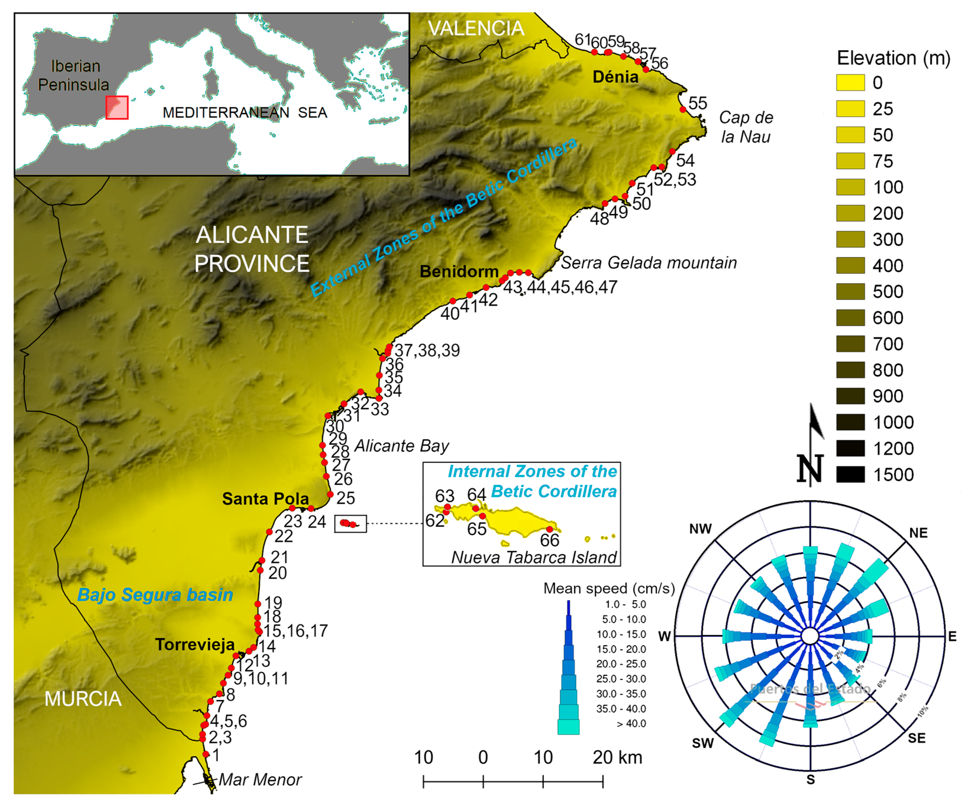
2.1. Study Area
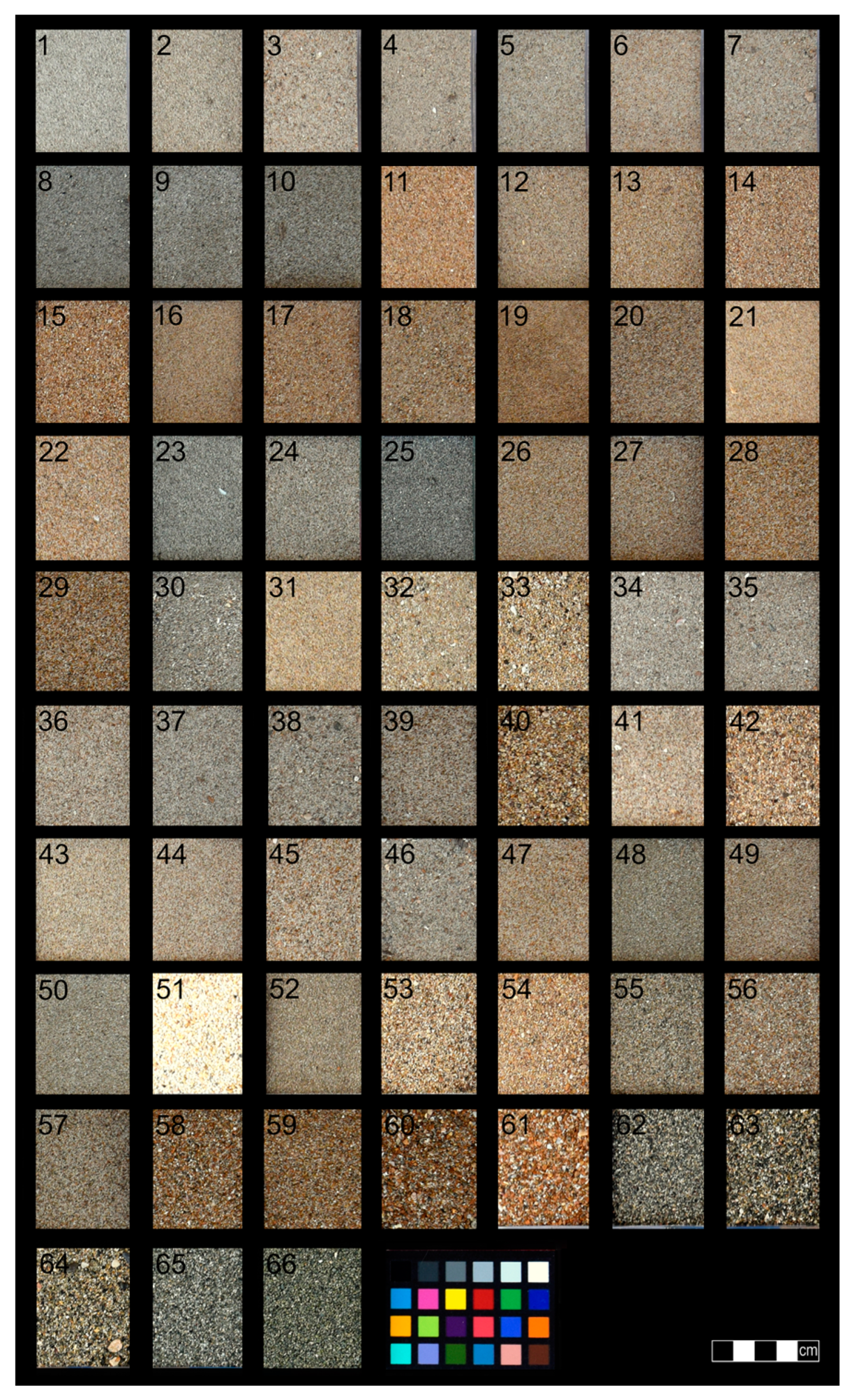
2.2. Sampling Design
2.3. Sand Colour Measurement and Analysis
3. Results and Discussion
3.1. Typology of Beaches
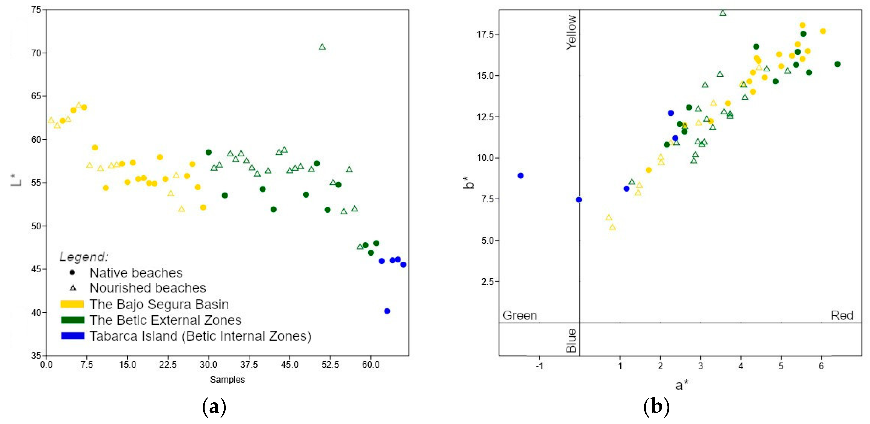
3.2. Sand Colour Analysis
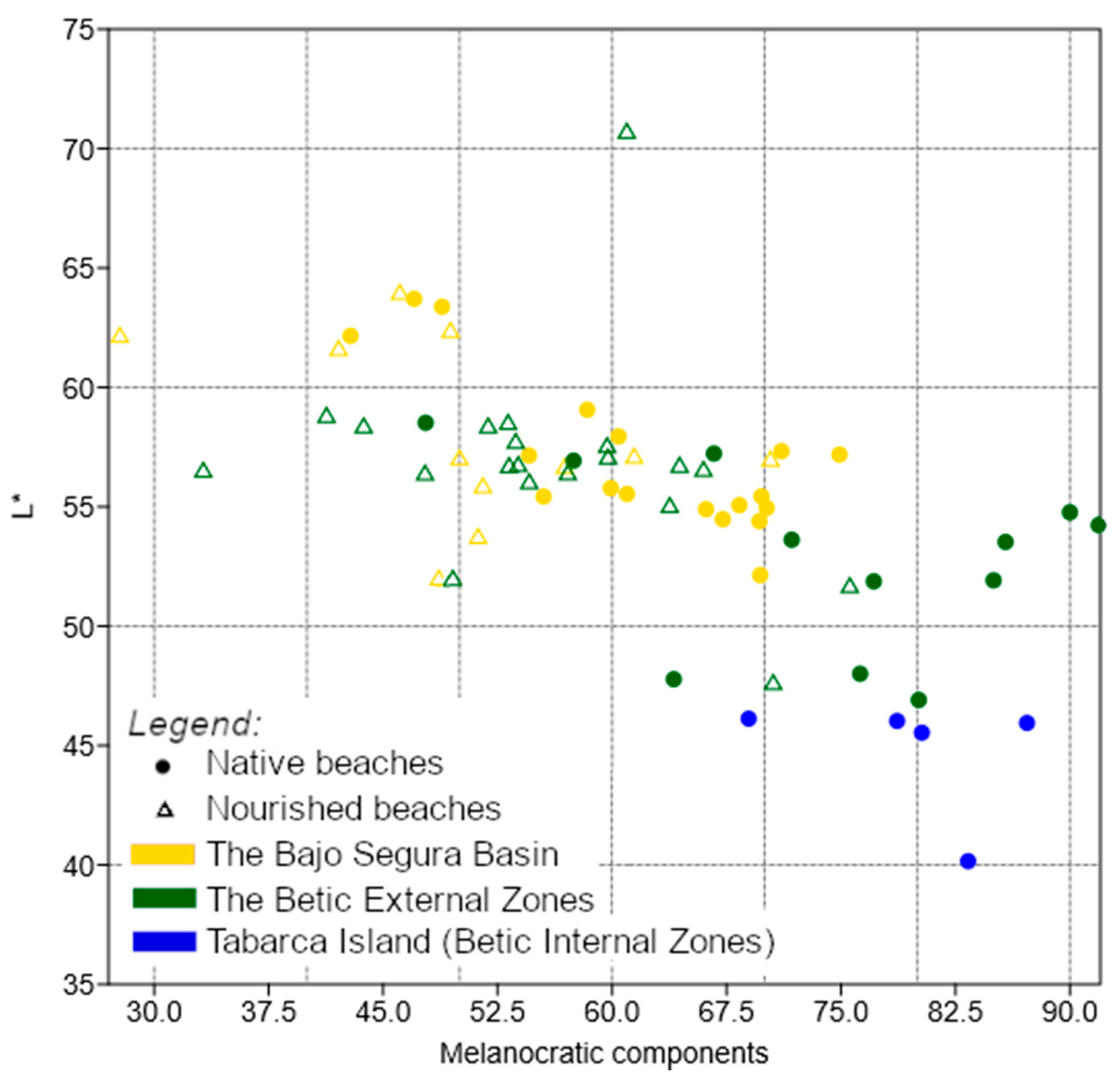
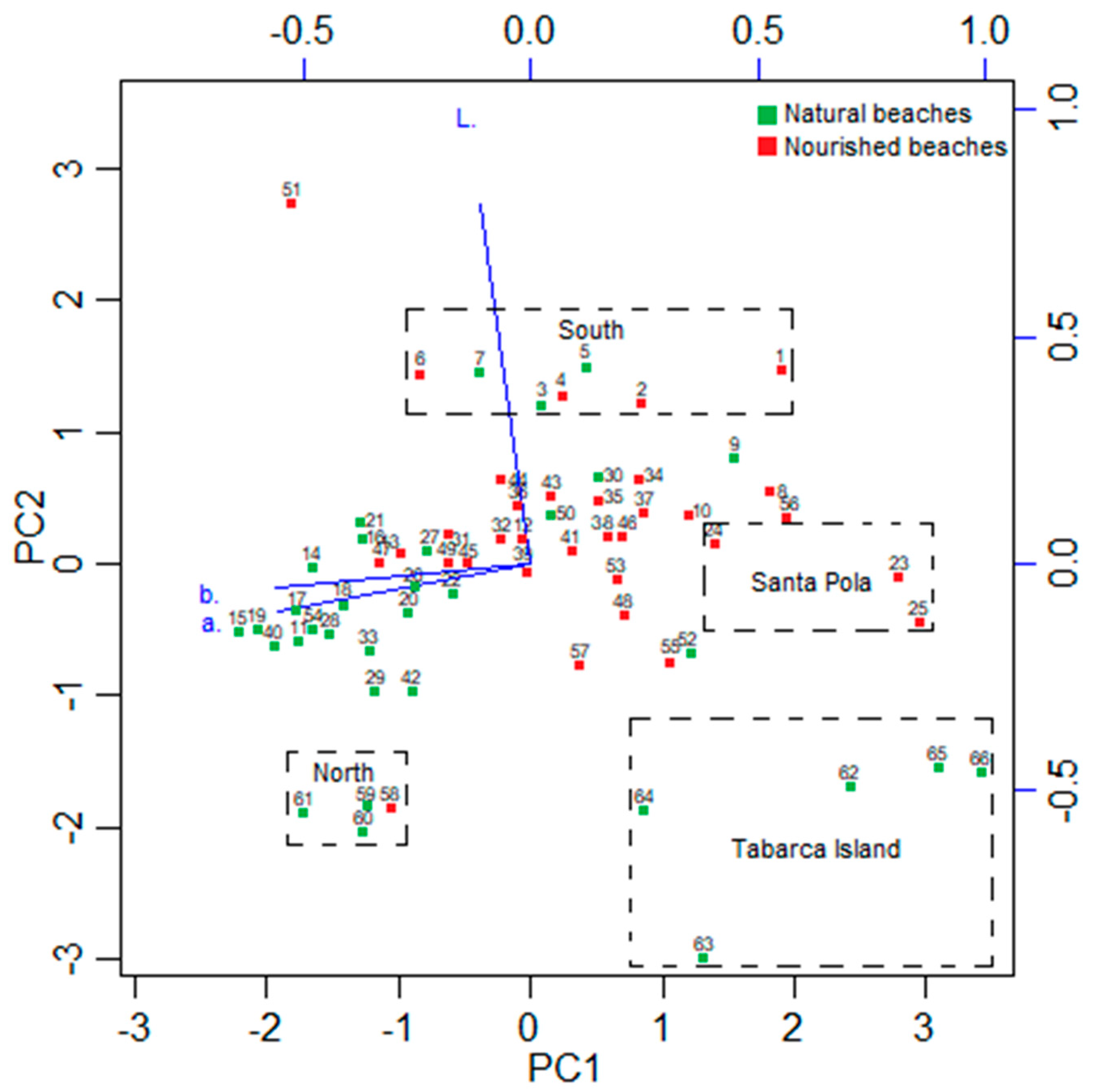
3.2.1. The L* Value
3.2.2. The a* and *b Plane
3.3. Mineralogical Characterization
3.4. Statistical Analysis
3.5. Grain Size Parameters
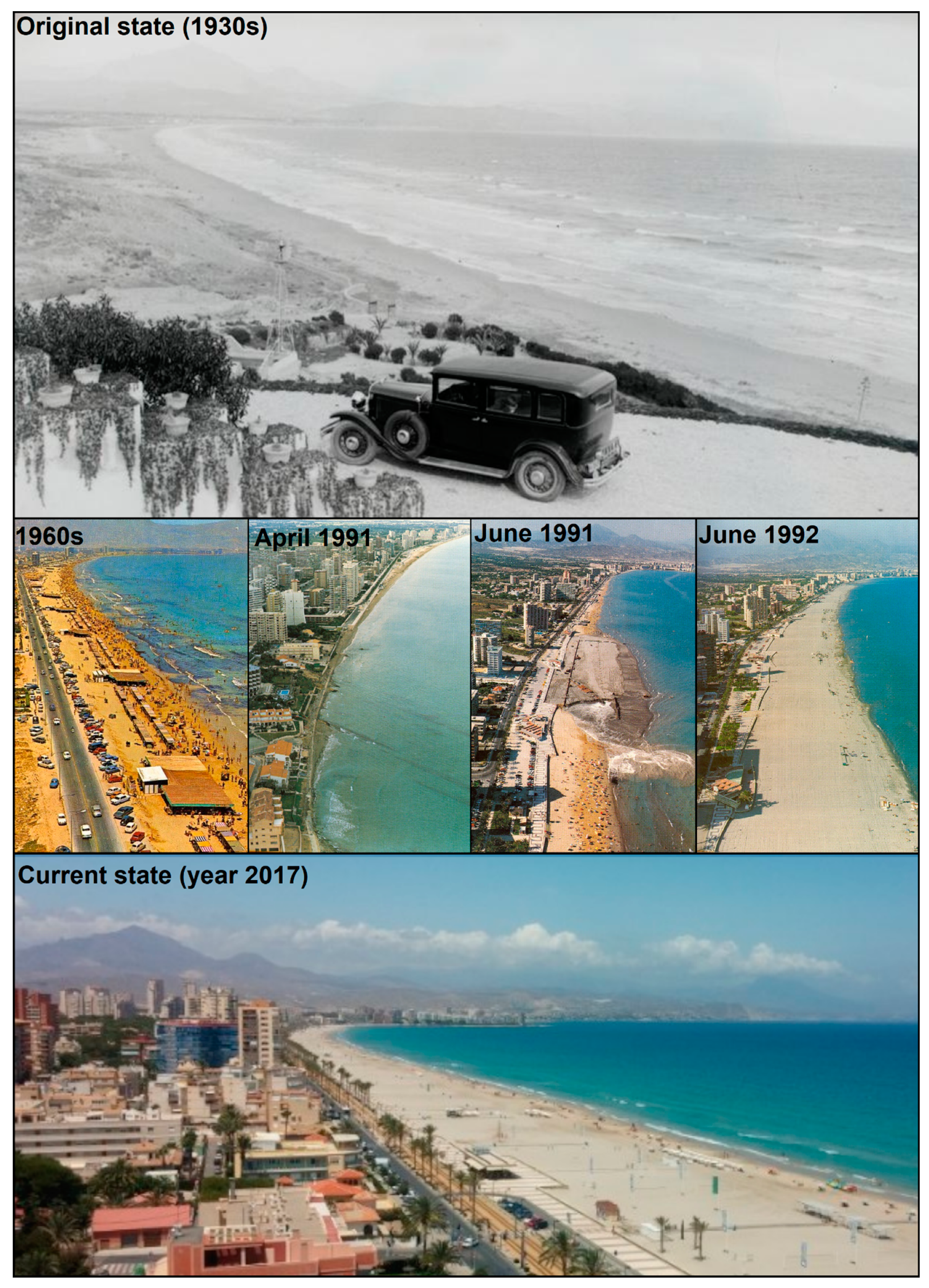
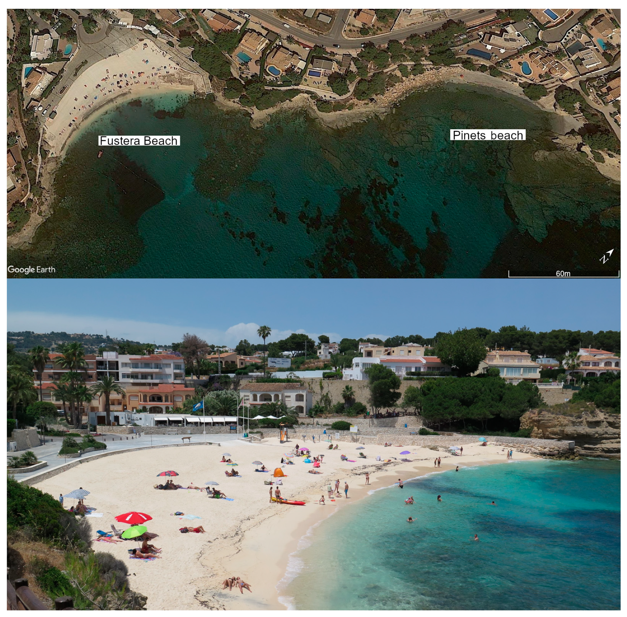
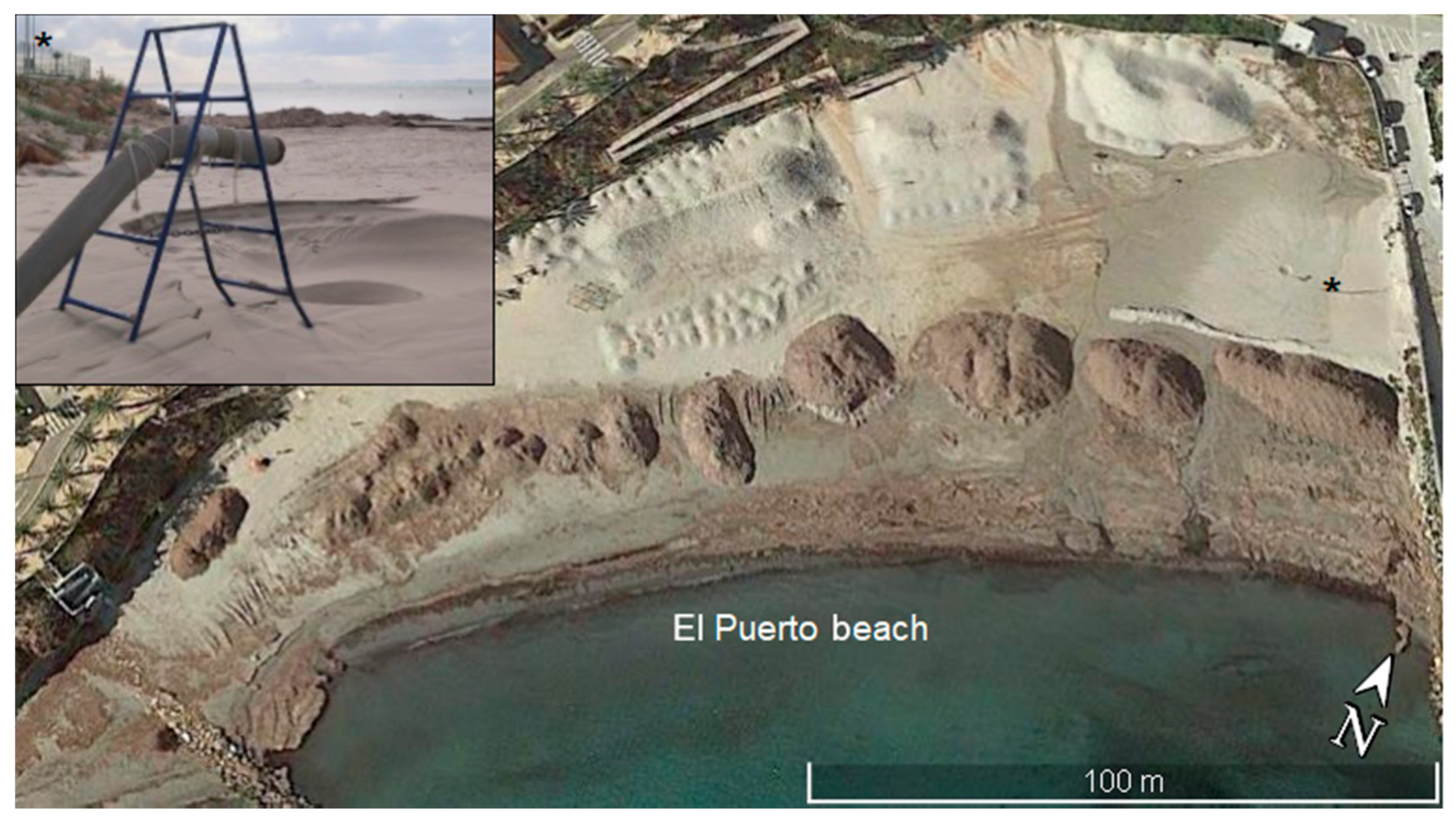
3.6. Colour Modification due to Human Activities
4. Conclusions
Author Contributions
Funding
Acknowledgments
Conflicts of Interest
Appendix A


| No. | Colour Parameters | Mineralogy | Grain Size Parameters (µm) | |||||
|---|---|---|---|---|---|---|---|---|
| L*(D65) | a*(D65) | b*(D65) | Leucocratic Comp. (%) | Melanocratic Comp. (%) | Mean | Mode | Median D50 | |
| 1 | 62.2 | 1.43 | 7.94 | 72.26 | 27.74 | 151.1 | 152.5 | 151.1 |
| 2 | 61.65 | 2.26 | 10.95 | 57.92 | 42.08 | 185.2 | 152.5 | 161.2 |
| 3 | 62.16 | 3.25 | 12.24 | 57.14 | 42.86 | 190.8 | 152.5 | 166.7 |
| 4 | 62.41 | 2.95 | 12.17 | 50.59 | 49.41 | 152.5 | 152.5 | 152.5 |
| 5 | 63.38 | 2.6 | 12 | 51.14 | 48.86 | 153.6 | 152.5 | 153.6 |
| 6 | 64 | 4.03 | 14.52 | 53.91 | 46.09 | 193.2 | 152.5 | 169.8 |
| 7 | 63.71 | 3.68 | 13.32 | 52.97 | 47.03 | 194.7 | 152.5 | 170.6 |
| 8 | 57.06 | 1.48 | 8.37 | 50.00 | 50.00 | 149.2 | 152.5 | 149.2 |
| 9 | 59.06 | 1.71 | 9.27 | 41.63 | 58.37 | 182.9 | 152.5 | 159.3 |
| 10 | 56.7 | 2.01 | 10.08 | 43.10 | 56.90 | 153.8 | 152.5 | 153.8 |
| 11 | 54.4 | 5.66 | 16.49 | 30.35 | 69.65 | 194.3 | 152.5 | 171.0 |
| 12 | 57.02 | 3.32 | 13.36 | 29.62 | 70.38 | 150.9 | 152.5 | 150.9 |
| 13 | 57.14 | 4.45 | 15.51 | 38.56 | 61.44 | 177.8 | 152.5 | 155.7 |
| 14 | 57.19 | 5.53 | 16.01 | 25.10 | 74.90 | 233.8 | 302.5 | 269.0 |
| 15 | 55.07 | 6.04 | 17.7 | 31.66 | 68.34 | 239.5 | 302.5 | 276.3 |
| 16 | 57.33 | 4.39 | 16.07 | 28.90 | 71.10 | 150.1 | 152.5 | 150.1 |
| 17 | 55.44 | 5.41 | 16.9 | 30.21 | 69.79 | 198.7 | 152.5 | 176.0 |
| 18 | 55.54 | 4.95 | 16.29 | 39.02 | 60.98 | 189.6 | 152.5 | 162.3 |
| 19 | 54.95 | 5.53 | 18.06 | 29.87 | 70.13 | 154.5 | 152.5 | 154.5 |
| 20 | 54.9 | 4.59 | 14.89 | 33.84 | 66.16 | 224.7 | 302.5 | 253.3 |
| 21 | 57.95 | 4.44 | 15.9 | 39.57 | 60.43 | 149.7 | 152.5 | 149.7 |
| 22 | 55.43 | 4.3 | 14.02 | 44.49 | 55.51 | 199.9 | 302.5 | 180.0 |
| 23 | 53.78 | 0.72 | 6.41 | 48.78 | 51.22 | 149.3 | 152.5 | 149.3 |
| 24 | 55.9 | 2.02 | 9.76 | 48.47 | 51.53 | 151.3 | 152.5 | 151.3 |
| 25 | 52 | 0.81 | 5.82 | 51.38 | 48.62 | 151.4 | 152.5 | 151.4 |
| 26 | 55.78 | 4.3 | 15.19 | 40.08 | 59.92 | 152.6 | 152.5 | 152.6 |
| 27 | 57.15 | 4.21 | 14.65 | 45.45 | 54.55 | 188.7 | 152.5 | 164.4 |
| 28 | 54.48 | 5.27 | 16.21 | 32.74 | 67.26 | 236.2 | 302.5 | 272.4 |
| 29 | 52.14 | 5 | 15.57 | 30.29 | 69.71 | 296.0 | 302.5 | 296.0 |
| 30 | 58.52 | 2.6 | 11.6 | 52.22 | 47.78 | 181.8 | 152.5 | 157.8 |
| 31 | 56.76 | 3.48 | 15.12 | 35.58 | 64.42 | 174.9 | 152.5 | 155.3 |
| 32 | 57.11 | 3.11 | 14.46 | 40.27 | 59.73 | 232.5 | 152.5 | 258.9 |
| 33 | 53.53 | 4.38 | 16.76 | 14.22 | 85.78 | 469.5 | 605.0 | 537.2 |
| 34 | 58.41 | 2.83 | 9.85 | 48.12 | 51.88 | 193.0 | 152.5 | 166.2 |
| 35 | 57.76 | 3.03 | 10.86 | 46.32 | 53.68 | 187.6 | 152.5 | 159.4 |
| 36 | 58.41 | 3.73 | 12.57 | 56.28 | 43.72 | 234.0 | 302.5 | 269.8 |
| 37 | 57.58 | 2.87 | 10.23 | 40.33 | 59.67 | 199.2 | 152.5 | 177.3 |
| 38 | 56.79 | 3.09 | 11 | 46.15 | 53.85 | 232.7 | 302.5 | 266.0 |
| 39 | 56.07 | 3.73 | 12.72 | 45.43 | 54.57 | 239.4 | 302.5 | 276.6 |
| 40 | 54.26 | 5.55 | 17.54 | 8.08 | 91.92 | 904.3 | 605.0 | 682.0 |
| 41 | 56.43 | 3.3 | 11.88 | 52.26 | 47.74 | 232.2 | 302.5 | 265.3 |
| 42 | 51.92 | 4.86 | 14.65 | 15.00 | 85.00 | 386.1 | 302.5 | 331.9 |
| 43 | 58.55 | 2.94 | 13 | 46.82 | 53.18 | 183.6 | 152.5 | 159.8 |
| 44 | 58.85 | 3.58 | 12.84 | 58.72 | 41.28 | 176.9 | 152.5 | 156.3 |
| 45 | 56.44 | 4.1 | 13.71 | 42.91 | 57.09 | 258.2 | 302.5 | 291.0 |
| 46 | 56.75 | 2.93 | 11.02 | 46.75 | 53.25 | 191.0 | 152.5 | 163.7 |
| 47 | 56.93 | 4.64 | 15.44 | 42.53 | 57.47 | 196.5 | 152.5 | 174.4 |
| 48 | 53.62 | 2.48 | 12.06 | 28.23 | 71.77 | 151.5 | 152.5 | 151.5 |
| 49 | 56.59 | 4.07 | 14.47 | 34.01 | 65.99 | 182.5 | 152.5 | 158.8 |
| 50 | 57.23 | 2.71 | 13.07 | 33.33 | 66.67 | 180.5 | 152.5 | 157.5 |
| 51 | 70.75 | 3.55 | 18.82 | 39.04 | 60.96 | 275.2 | 302.5 | 280.9 |
| 52 | 51.88 | 2.16 | 10.81 | 22.85 | 77.15 | 176.0 | 152.5 | 155.8 |
| 53 | 55.07 | 2.61 | 11.94 | 36.22 | 63.78 | 290.1 | 302.5 | 292.3 |
| 54 | 54.77 | 5.41 | 16.44 | 10.00 | 90.00 | 624.0 | 605.0 | 615.2 |
| 55 | 51.72 | 2.4 | 10.95 | 24.42 | 75.58 | 237.1 | 302.5 | 273.7 |
| 56 | 56.55 | 1.29 | 8.57 | 66.79 | 33.21 | 189.6 | 152.5 | 167.6 |
| 57 | 52.02 | 3.15 | 12.39 | 50.43 | 49.57 | 185.1 | 152.5 | 161.4 |
| 58 | 47.66 | 5.16 | 15.32 | 29.44 | 70.56 | 292.6 | 302.5 | 292.6 |
| 59 | 47.78 | 5.37 | 15.66 | 35.96 | 64.04 | 299.4 | 302.5 | 299.4 |
| 60 | 46.91 | 5.69 | 15.19 | 19.90 | 80.10 | 572.2 | 605.0 | 559.0 |
| 61 | 48.01 | 6.4 | 15.7 | 23.75 | 76.25 | 470.3 | 605.0 | 538.1 |
| 62 | 45.95 | 1.16 | 8.14 | 12.81 | 87.19 | 380.3 | 302.5 | 330.7 |
| 63 | 40.16 | 2.37 | 11.21 | 16.67 | 83.33 | 593.4 | 605.0 | 593.4 |
| 64 | 46.03 | 2.26 | 12.73 | 21.33 | 78.67 | 464.1 | 605.0 | 534.1 |
| 65 | 46.13 | −0.03 | 7.48 | 31.05 | 68.95 | 348.9 | 302.5 | 304.4 |
| 66 | 45.54 | −1.47 | 8.93 | 19.70 | 80.30 | 605.0 | 605.0 | 605.0 |
| L* | a* | b* | Leucocratic Components | Melanocratic Components | |
|---|---|---|---|---|---|
| L* | 1 | 0.058 | 0.119 | 0.624 | −0.624 |
| a* | 1 | 0.890 | −0.302 | 0.302 | |
| b* | 1 | −0.402 | 0.402 | ||
| Leucocratic components | 1 | −1 | |||
| Melanocratic components | 1 |
References
- Pranzini, E.; Vitale, G. Beach Sand Colour: The Need for a Standardised Assessment Procedure. J. Coast. Res. 2011, 61, 66–69. [Google Scholar] [CrossRef]
- Roca, E.; Riera, C.; Villares, M.; Fragell, R.; Junyent, R. A combined assessment of beach occupancy and public perceptions of beach quality: A case study in the Costa Brava, Spain. Ocean. Coast. Manag. 2008, 51, 839–846. [Google Scholar] [CrossRef]
- Pranzini, E.; Simonetti, D.; Vitale, G. Sand colour rating and chromatic compatibility of borrow sediments. J. Coast. Res. 2010, 26, 798–808. [Google Scholar] [CrossRef]
- Ergin, A.; Karaesmen, E.; Micallef, A.; Williams, A.T. A new methodology for evaluating coastal scenery: Fuzzy logic systems. Area 2004, 36, 367–386. [Google Scholar] [CrossRef]
- Rangel-Buitrago, N. Coastal Scenery: Evaluation and Management; Springer: Cham, Switzerland, 2018. [Google Scholar]
- Asensio-Montesinos, F.; Anfuso, G.; Corbí, H. Coastal scenery and litter impacts at Alicante (SE Spain): Management issues. J. Coast. Cons. 2019, 23, 185–201. [Google Scholar] [CrossRef]
- Peterson, C.H.; Bishop, M.J. Assessing the environmental impacts of beach nourishment. Bioscience 2005, 55, 887–896. [Google Scholar] [CrossRef] [Green Version]
- Anfuso, G.; Williams, A.T.; Hernández, J.C.; Pranzini, E. Coastal scenic assessment and tourism management in western Cuba. Tour. Manag. 2014, 42, 307–320. [Google Scholar] [CrossRef]
- Cárdenes, V.; Rubio, A. Measure of the color of beach nourishment sands: A case study from the Belgium coast. Trabajos de Geología 2015, 35, 7–18. [Google Scholar] [CrossRef] [Green Version]
- Pranzini, E. Protection studies at two recreational beaches: Poetto and Cala Gonone beaches, Sardinia, Italy. In Beach Management; Williams, A.T., Micallef, A., Eds.; Earthscan publishers: London, UK, 2009; pp. 287–306. [Google Scholar]
- Houston, J.R. The economic value of beaches-a 2013 update. Shore Beach 2013, 81, 3–11. [Google Scholar]
- Aragonés, L.; López, I.; Villacampa, Y.; Serra, J.C.; Saval, J.M. New methodology for the classification of gravel beaches: Adjusted on Alicante (Spain). J. Coast. Res. 2014, 3, 1023–1034. [Google Scholar] [CrossRef] [Green Version]
- Corbí, H.; Asensio-Montesinos, F.; Ramos-Esplá, A.A. The littoral bottoms of Benidorm Island (western Mediterranean Sea): Eco-sedimentological characterization through benthic foraminifera. Thalassas 2016, 32, 105–115. [Google Scholar] [CrossRef]
- López, I.; López, M.; Aragonés, L.; García-Barba, J.; López, M.P.; Sánchez, I. The erosion of the beaches on the coast of Alicante: Study of the mechanisms of weathering by accelerated laboratory tests. Sci. Total Environ. 2016, 566, 191–204. [Google Scholar] [CrossRef] [PubMed]
- Pagán, J.I.; Aragonés, L.; Tenza-Abril, A.J.; Pallarés, P. The influence of anthropic actions on the evolution of an urban beach: Case study of Marineta Cassiana beach, Spain. Sci. Total Environ. 2016, 559, 242–255. [Google Scholar] [CrossRef] [PubMed]
- López, M.; Baeza-Brotons, F.; López, I.; Tenza-Abril, A.J.; Aragonés, L. Mineralogy and morphology of sand: Key parameters in the durability for its use in artificial beach nourishment. Sci. Total Environ. 2018, 639, 186–194. [Google Scholar] [CrossRef] [PubMed]
- Pardo-Pascual, J.E.; Sanjaume, E. Beaches in Valencian Coast. In The Spanish Coastal Systems; Springer: Cham, Switzerland, 2019; pp. 209–236. [Google Scholar]
- Pranzini, E. Il colore della sabbia: Percezione, caratterizzazione e compatibilità nel ripascimento artificiale delle spiagge. Studi Costieri. 2008, 15, 101–122. [Google Scholar]
- Fernández-Fernández, S.; Bernabeu, A.M.; Rey, D.; Rubio, B.; Vilas, F. Determinación del color como herramienta de detección de contaminación por fuel en playas arenosas. Geogaceta 2011, 50, 165–168. [Google Scholar]
- Bigongiari, N.; Cipriani, L.E.; Pranzini, E.; Renzi, M.; Vitale, G. Assessing shelf aggregate environmental compatibility and suitability for beach nourishment: A case study for Tuscany (Italy). Mar. Pollut. Bull. 2015, 93, 183–193. [Google Scholar] [CrossRef]
- Cárdenes, V.; Pedrosa, E.S. Propuestas de actividad didáctica para el estudio del, tamaño y composición de arenas de playa. Un caso práctico en la costa de Bélgica. Enseñanza de las Ciencias de la Tierra 2015, 23, 315. [Google Scholar]
- Corbí, H.; Martínez-Martínez, J. Interpretando ambientes sedimentarios: Taller de sedimentología con arenas como actividad didáctica de Ciencias de la Tierra. Enseñanza de las Ciencias de la Tierra 2015, 23, 242. [Google Scholar]
- Corbí, H.; Martínez-Martínez, J.; Martin-Rojas, I. Linking Geological and Architectural Heritage in a Singular Geosite: Nueva Tabarca Island (SE Spain). Geoheritage 2019, 11, 703–716. [Google Scholar] [CrossRef]
- Gilabert, E.J. Medida del color; Universidad Politécnica de Valencia: Valencia, Spain, 1992; p. 177. [Google Scholar]
- Comission Internationale de l’Eclairage. Recommendations on Uniform Color Spaces: Color-Difference Equations; Psychometric Color Terms; CIE Publication 15 Bureau Central de la CIE Paris: Paris, France, 1976. [Google Scholar]
- Pranzini, E.; Anfuso, G.; Botero, C.M.; Cabrera, A.; Campos, Y.A.; Martinez, G.C.; Williams, A.T. Sand colour at Cuba and its influence on beach nourishment and management. Ocean. Coast. Manag. 2016, 126, 51–60. [Google Scholar]
- Guedes, A.; Ribeiro, H.; Valentim, B.; Noronha, F. Quantitative colour analysis of beach and dune sediments for forensic applications: A Portuguese example. Forensic Sci. Int. 2009, 190, 42–51. [Google Scholar] [CrossRef] [PubMed]
- Harris, A.C.; Weatherall, I.L. Geographic variation for colour in the sandburrowing beetle Chaerodes trachyscelides White (Coleoptera: Tenebrionidae) on New Zealand beaches analysed using CIELAB L* values. Biol. J. Linn. Soc. 1991, 44, 93–104. [Google Scholar] [CrossRef]
- Tsujimoto, G.; Tamai, M. Analysis of beach sand colour and its application to sedimentation. In Proceedings of the 7th International Conference on Asian and Pacific Coasts (APAC 2013), Bali, Indonesia, 24–26 September 2013; pp. 141–146. [Google Scholar]
- Estévez, A.; Vera, J.A.; Alfaro, P.; Andreu, J.M.; Tent-Manclús, J.E.; Yébenes, A. Geología de la provincia de Alicante. Enseñanza de las Ciencias de la Tierra 2004, 12, 2–15. [Google Scholar]
- Alfaro, P.; Andreu, J.M.; Estévez, A.; Tent-Manclús, J.E.; Yébenes, A. Geología de Alicante; AEPECT—University of Alicante: Alicante, Spain, 2004. [Google Scholar]
- Corbí, H.; Soria, J.M.; Lancis, C.; Giannetti, A.; Tent-Manclús, J.E.; Dinarès-Turell, J. Sedimentological and paleoenvironmental scenario before, during, and after the Messinian Salinity Crisis: The San Miguel de Salinas composite section (western Mediterranean). Mar. Geol. 2016, 379, 246–266. [Google Scholar]
- Corbí, H.; Soria, J.M. Late Miocene–early Pliocene planktonic foraminifer event-stratigraphy of the Bajo Segura basin: A complete record of the western Mediterranean. Mar. Petrol. Geol. 2016, 77, 1010–1027. [Google Scholar]
- Alfaro, P.; Andreu, J.M.; Estévez, A.; Pina, J.A.; Yébenes, A. Itinerarios Geológicos por la Provincia de Alicante; Publicaciones de la Universidad de Alicante: Alicante, Spain, 2008; p. 317. [Google Scholar]
- Martínez-Martínez, J.; Corbí, H.; Martin-Rojas, I.; Baeza-Carratalá, J.F.; Giannetti, A. Stratigraphy, petrophysical characterization and 3D geological modelling of the historical quarry of Nueva Tabarca island (western Mediterranean): Implications on heritage conservation. Eng Geol. 2017, 231, 88–99. [Google Scholar] [CrossRef] [Green Version]
- Díaz Orueta, F.; Lourés Seoane, M.L. La globalización de los mercados inmobiliarios: Su impacto sobre la Costa Blanca. CyTET 2008, XL, 77–92. [Google Scholar]
- Ergin, A.; Williams, A.T.; Micallef, A. Coastal scenery: Appreciation and evaluation. J. Coast. Res. 2006, 22, 958–964. [Google Scholar] [CrossRef]
- Botero, C.; Anfuso, G.; Williams, A.T.; Palacios, A. Perception of coastal scenery along the Caribbean littoral of Colombia. J. Coast. Res. 2013, 65, 1733–1739. [Google Scholar] [CrossRef]
- Williams, A.T.; Rangel-Buitrago, N.G.; Anfuso, G.; Cervantes, O.; Botero, C.M. Litter impacts on scenery and tourism on the Colombian north Caribbean coast. Tour. Manag. 2016, 55, 209–224. [Google Scholar] [CrossRef]
- El Naturalista Digital. Las playas del Parque Regional de los “Arenales” de San Pedro, en regresión por las actuaciones sobre los arribazones que las protegen. Available online: elnaturalistadigital.blogspot.com/2006/07/las-playas-del-parque-regional-de-los.html (accessed on 13 January 2020).
- Diputación Provincial de Alicante. Senderos de la Arena. Guía de Playas de la Provincia de Alicante; Diputación de Alicante, Área de Medio Ambiente: Alicante, Spain, 2010; p. 248. [Google Scholar]
- Gobierno de España. Ministerio para la Transición Ecológica. Guía de Playas. Available online: https://www.miteco.gob.es/es/costas/servicios/guia-playas/ (accessed on 13 January 2020).
- Instituto Geográfico Nacional. Plano del fondeadero de Lugar Nuevo. Dirección Hidrográfica, Cádiz, 1813. Available online: http://www.ign.es/web/catalogo-cartoteca/resources/pdfcards/card009746.pdf (accessed on 13 January 2020).
- Corbí, H.; Riquelme, A.; Megías-Baños, C.; Abellan, A. 3-D morphological change analysis of a beach with seagrass berm using a terrestrial laser scanner. ISPRS Int. Geo-Inf. 2018, 7, 234. [Google Scholar]
- Pagán, J.I.; López, M.; López, I.; Tenza-Abril, A.J.; Aragonés, L. Study of the evolution of gravel beaches nourished with sand. Sci. Total Environ. 2018, 626, 87–95. [Google Scholar]
- Bajoelagua. Bruselas denuncia a España por las regeneraciones de playas en Baleares y Alicante. Available online: www.bajoelagua.com/articulos/noticias-buceo/1385.htm (accessed on 13 January 2020).
- Aragonés, L.; García-Barba, J.; García-Bleda, E.; López, I.; Serra, J.C. Beach nourishment impact on Posidonia oceanica: Case study of Poniente Beach (Benidorm, Spain). Ocean Eng. 2015, 107, 1–12. [Google Scholar] [CrossRef]
- Diario Información. Benidorm desiste de cubrir “el llosar” de Levante con arena. Available online: www.diarioinformacion.com/benidorm/2012/02/05/benidorm-desiste-cubrir-llosar-levante-arena/1219915.html (accessed on 13 January 2020).
- Diario Información. 8.000 toneladas de arena para paliar los efectos del temporal en Cala Fustera de Benissa. Available online: www.diarioinformacion.com/marina-alta/2017/03/21/8000-toneladas-arena-paliar-efectos/1874226.html (accessed on 13 January 2020).
- Chiva, L.; Pagán, J.I.; López, I.; Tenza-Abril, A.J.; Aragonés, L.; Sánchez, I. The effects of sediment used in beach nourishment: Study case El Portet de Moraira beach. Sci. Total Environ. 2018, 628, 64–73. [Google Scholar] [CrossRef] [PubMed] [Green Version]
- Alicante Plaza. Xàbia retira el dique de arena de la playa que se alzó para frenar el temporal. Available online: alicanteplaza.es/Xbiaretiraeldiquedearenadelaplayaquesealzparafrenareltemporal (accessed on 13 January 2020).
- Aberasturi, A.; Acosta, J.; Aguilera, J.C.; Alfaro, P.; Andreu, J.M.; Antón, I.; Zaragozí, A. Geolodía 17. Alicante: Isla de Nueva Tabarca 2017, 7, 43. [Google Scholar]
- Blott, S.J.; Pye, K. GRADISTAT: A grain size distribution and statistics package for the analysis of unconsolidated sediments. Earth Surf. Process. Landf. 2001, 26, 1237–1248. [Google Scholar] [CrossRef]
- Folk, R.L.; Ward, W.C. Brazos River bar: A study in the significance of grain size parameters. J. Sed. Petrol. 1957, 27, 3–26. [Google Scholar] [CrossRef]
- Williams, A.T.; Micallef, A. Beach Management. Principles and Practice; Earthscan: London, UK, 2009; p. 480. [Google Scholar]
- González-Correa, J.M.; Fernández-Torquemada, Y.; Sánchez-Lizaso, J.L. Short-term effect of beach replenishment on a shallow Posidonia oceanica meadow. Mar. Environ. Res. 2009, 68, 143–150. [Google Scholar]
- López-Andrés, L. La Regeneración de las playas de San Juan y Muchavista en 1991. Available online: http://www.alicantevivo.org/2008/06/la-regeneracin-de-las-playas-de-san.html (accessed on 22 November 2019).
- Tenza-Abril, A.J.; Pagán, J.I.; Aragonés, L.; Saval, J.M.; Serra, J.C.; López, I. 60 years of urban development in Denia and its influence on the Marineta Cassiana beach. Int. J. of Sust. Dev. Plan 2017, 12, 678–686. [Google Scholar] [CrossRef] [Green Version]
- Bricio Garberí, L.; Negro Valdecantos, V.; Diez Gonzalez, J.J.; López Gutiérrez, J.S. Diseño funcional y ambiental de diques exentos de baja cota de coronación. Ing. Civ. 2010, 158, 53–61. [Google Scholar]
- Martínez-Medina, A. Arquitectura del boom turístico (1953–1979). In El turismo en Alicante y la Costa Blanca Canelobre 2016, 66, 166–185. [Google Scholar]
- Delgado, J.; Casado, C.L.; Estevez, A.; Giner, J.; Cuenca, A.; Molina, S. Mapping soft soils in the Segura river valley (SE Spain): A case study of microtremors as an exploration tool. J. Appl. Geophys 2000, 45, 19–32. [Google Scholar] [CrossRef]
- Gilabert, E.; Martínez-Verdú, F. Medida de la luz y el color. Tomo 2: Aplicaciones; Valencia: Servicio de Publicaciones de la Universidad Politécnica de Valencia: Valencia, Spain, 2007; p. 251. [Google Scholar]
- Martínez-Martínez, J.; Pola, A.; García-Sánchez, L.; Reyes Agustín, G.; Osorio Ocampo, L.S.; Macías Vázquez, J.L.; Robles-Camacho, J. Building stones used in the architectural heritage of Morelia (México): Quarries location, rock durability and stone compatibility in the monument. Environ. Earth Sci. 2018, 77, 167–182. [Google Scholar] [CrossRef]
- Batalla, R.J. Sediment deficit in rivers caused by dams and instream gravel mining. Are view with examples from NE Spain. Rev C. & G. 2003, 17, 79–91. [Google Scholar]
- Liquete, C.; Canals, M.; Arnau, P.; Urgeles, R.; Durrieu de Madron, X. The impact of humans on strata formation along Mediterranean margins. Oceanography 2004, 17, 70–79. [Google Scholar] [CrossRef] [Green Version]
- Giannetti, A.; Monaco, P.; Falces-Delgado, S.; La Iacona, F.G.; Corbí, H. Taphonomy, ichnology, and palaeoecology to distinguish event beds in varied shallow-water settings (Betic Cordillera, SE Spain). J. Iber Geol. 2019, 45, 47–61. [Google Scholar] [CrossRef]
- Cuevas-González, J.; Díez-Canseco, D.; Alfaro, P.; Andreu, J.M.; Baeza-Carratalá, J.M.; Benavente, D.; Blanco-Quintero, I.; Cañaveras, J.C.; Corbí, H.; Delgado, J.; et al. Geogymkhana-Alicante (Spain): Geoheritage through Education. Geoheritage 2020, (in press). [Google Scholar]
- Ayuntamiento de Alicante. Alicante en los años 30. Exposición en el archivo municipal. Available online: https://www.alicante.es/es/agenda/alicante-anos-30-exposicion-archivo-municipal (accessed on 13 January 2020).
- Pinterest. Playa de San Juan en los años 60, Alicante, España. Available online: https://www.pinterest.es/pin/450782243935888731/?lp=true (accessed on 9 January 2020).
- Biroupeplaja. Available online: http://www.biroupeplaja.ro/plaja-san-juan-din-alicante-spania-villa-royal/ (accessed on 9 January 2020).
- Diario Información. Pilar de la Horadada regenera sus playas con más de 30000m3 de arena. Available online: https://www.diarioinformacion.com/vega-baja/2015/07/07/playas-pilar-han-sido-regeneradas/1653097.html (accessed on 9 January 2020).
- La crónica independiente. Las playas del Pilar han sido regeneradas con más de 30.000 m3 de arena, “el doble que otros años”. Available online: http://lacronicaindependiente.com/2015/07/las-playas-del-pilar-han-sido-regeneradas-con-mas-de-30-000-m3-de-arena-el-doble-que-otros-anos/ (accessed on 9 January 2020).


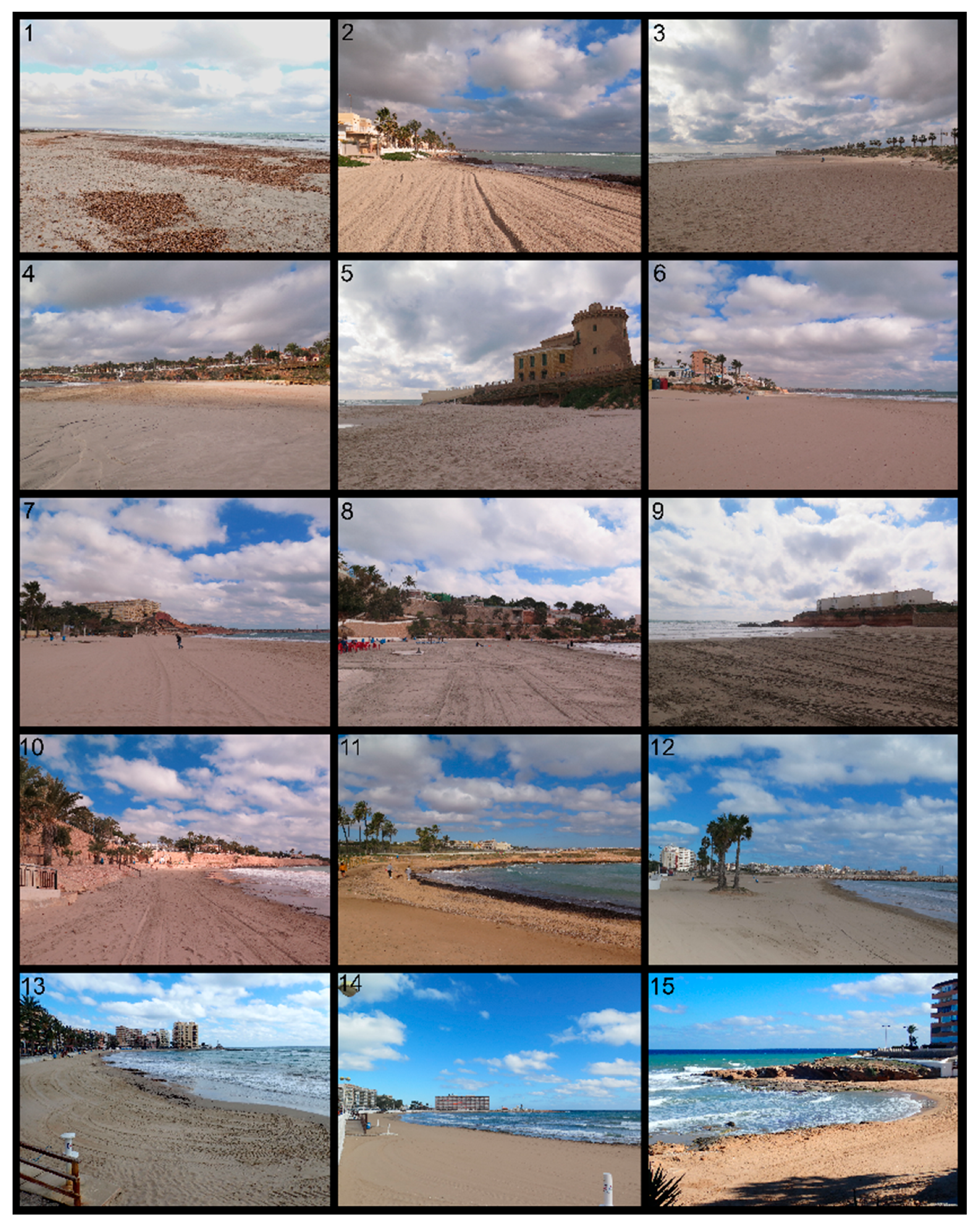
| No. | Beach | Municipality | Typology | Sand Condition | Source |
|---|---|---|---|---|---|
| 1 | Torre Derribada | San Pedro del Pinatar | Rural | Nourished | [40] |
| 2 | El Mojón | Pilar de la Horadada | Village | Nourished | [41]; Environmental services a |
| 3 | Las Higuericas | Pilar de la Horadada | Village | Native | [42] |
| 4 | El Puerto | Pilar de la Horadada | Urban | Nourished | [41]; Environmental services a |
| 5 | El Conde | Pilar de la Horadada | Urban | Native | [42] |
| 6 | Mil Palmeras | Pilar de la Horadada | Urban | Nourished | Environmental services a |
| 7 | La Glea | Orihuela | Village | Native | [42] |
| 8 | Cabo Roig | Orihuela | Urban | Nourished | [41]; Coastscape 1956 b |
| 9 | La Estaca | Orihuela | Urban | Native | [42] |
| 10 | Punta Prima | Orihuela | Urban | Nourished | [41,42] |
| 11 | Cala Ferri | Torrevieja | Rural | Native | [41] |
| 12 | Los Náufragos | Torrevieja | Urban | Nourished | [41]; Coastscape 1956 b |
| 13 | Playa del Cura | Torrevieja | Urban | Nourished | [41] |
| 14 | Los Locos | Torrevieja | Urban | Native | [41] |
| 15 | Cala Cervera | Torrevieja | Urban | Native | [41] |
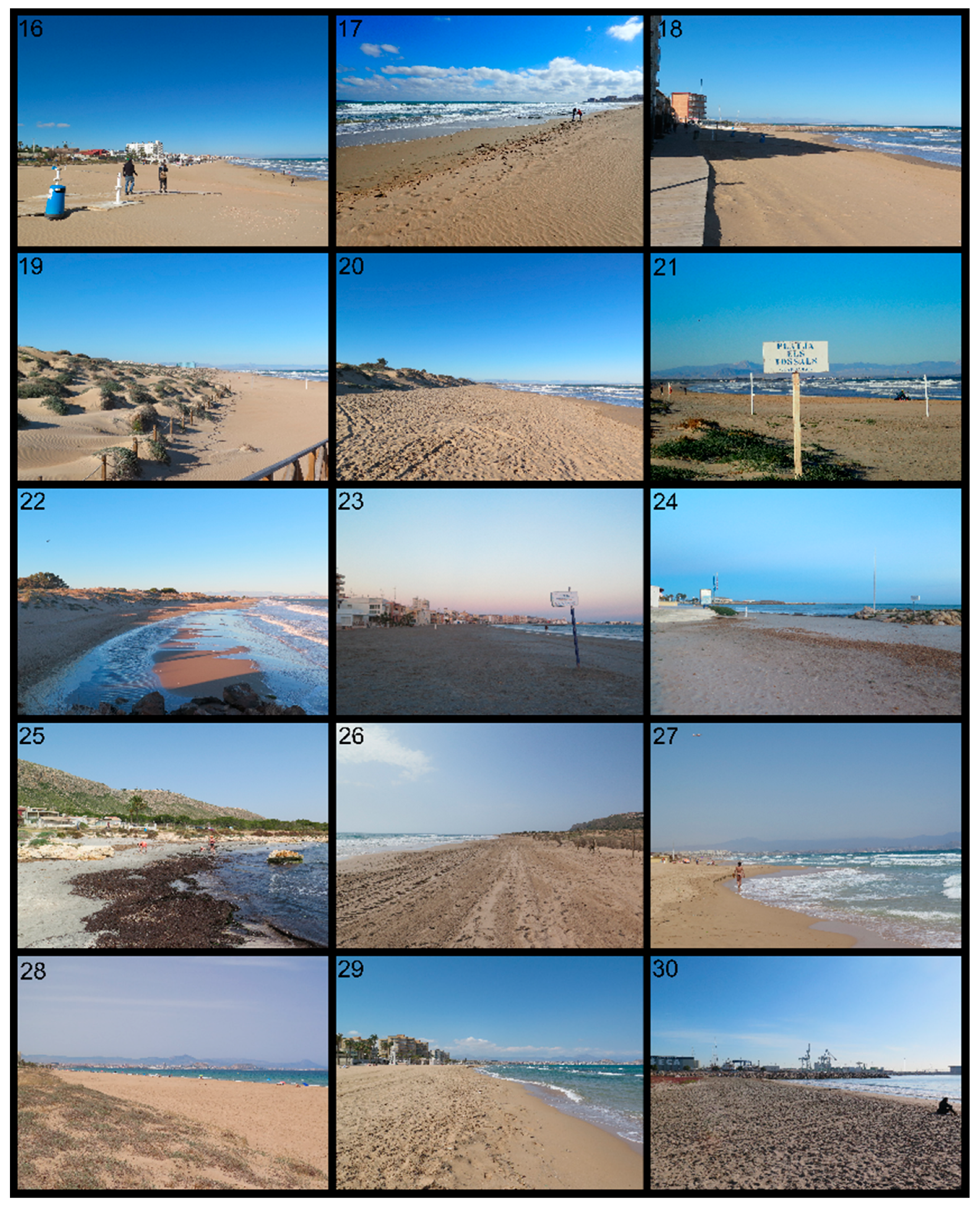
| 16, 17 | La Mata | Torrevieja | Village | Native | [41] |
| 18 | Torrelamata | Torrevieja | Urban | Native | [41] |
| 19 | Les Ortigues | Guardamar del Segura | Remote | Native | [41] |
| 20 | Els Vivers | Guardamar del Segura | Rural | Native | [41] |
| 21 | Els Tossals | Guardamar del Segura | Remote | Native | [41,42] |
| 22 | El Pinet | Elx | Rural | Native | [41,42] |
| 23 | Playa Lisa | Santa Pola | Urban | Nourished | [41] |
| 24 | Bernabeu II | Santa Pola | Urban | Nourished | [41]; Coastscape 1956 b |
| 25 | Calas del Cuartel | Santa Pola | Rural | Nourished | [43,44] |
| 26 | El Carabassí | Elx | Remote | Native | [41,42] |
| 27 | Arenales del Sol | Elx | Urban | Native | [41,42] |
| 28 | El Altet | Elx | Remote | Native | [41,42] |
| 29 | El Saladar | Alicante | Urban | Native | [41,42] |
| 30 | San Gabriel | Alicante | Urban | Native | Coastscape 1956 b |
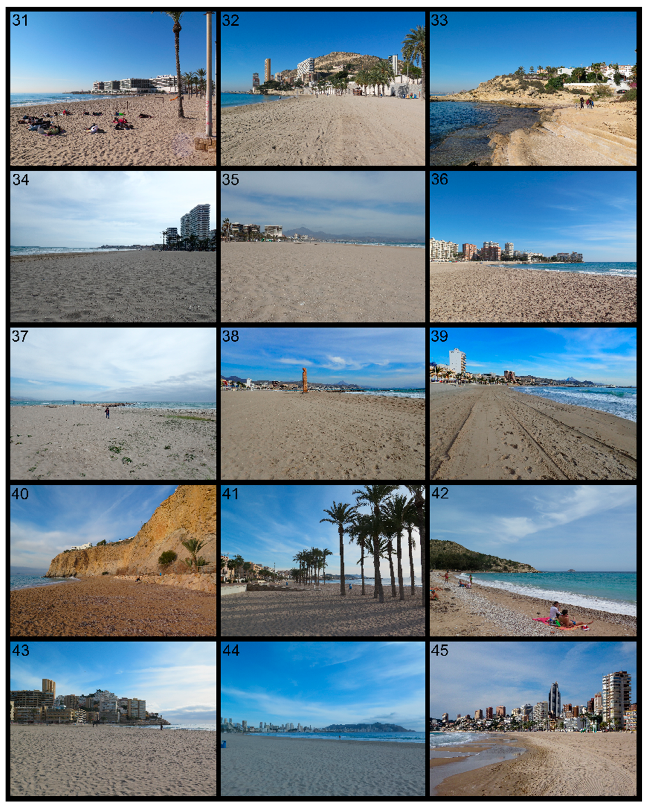
| 31 | El Postiguet | Alicante | Urban | Nourished | [41] |
| 32 | La Albufereta | Alicante | Urban | Nourished | [41,42] |
| 33 | Cala Palmera | Alicante | Rural | Native | [41] |
| 34, 35 | San Juan | Alicante | Urban | Nourished | [41] |
| 36 | Muchavista | El Campello | Urban | Nourished | [41] |
| 37–39 | Carrer La Mar | El Campello | Urban | Nourished | [41,45] |
| 40 | Bon-Nou | La Vila Joiosa | Rural | Native | [41] |
| 41 | Playa Centro | La Vila Joiosa | Urban | Nourished | Coastscape 1956 b; [45] |
| 42 | El Torres | La Vila Joiosa | Rural | Native | [41]; Coastscape 1956 b |
| 43 | Cala Finestrat | Finestrat | Urban | Nourished | [46] |
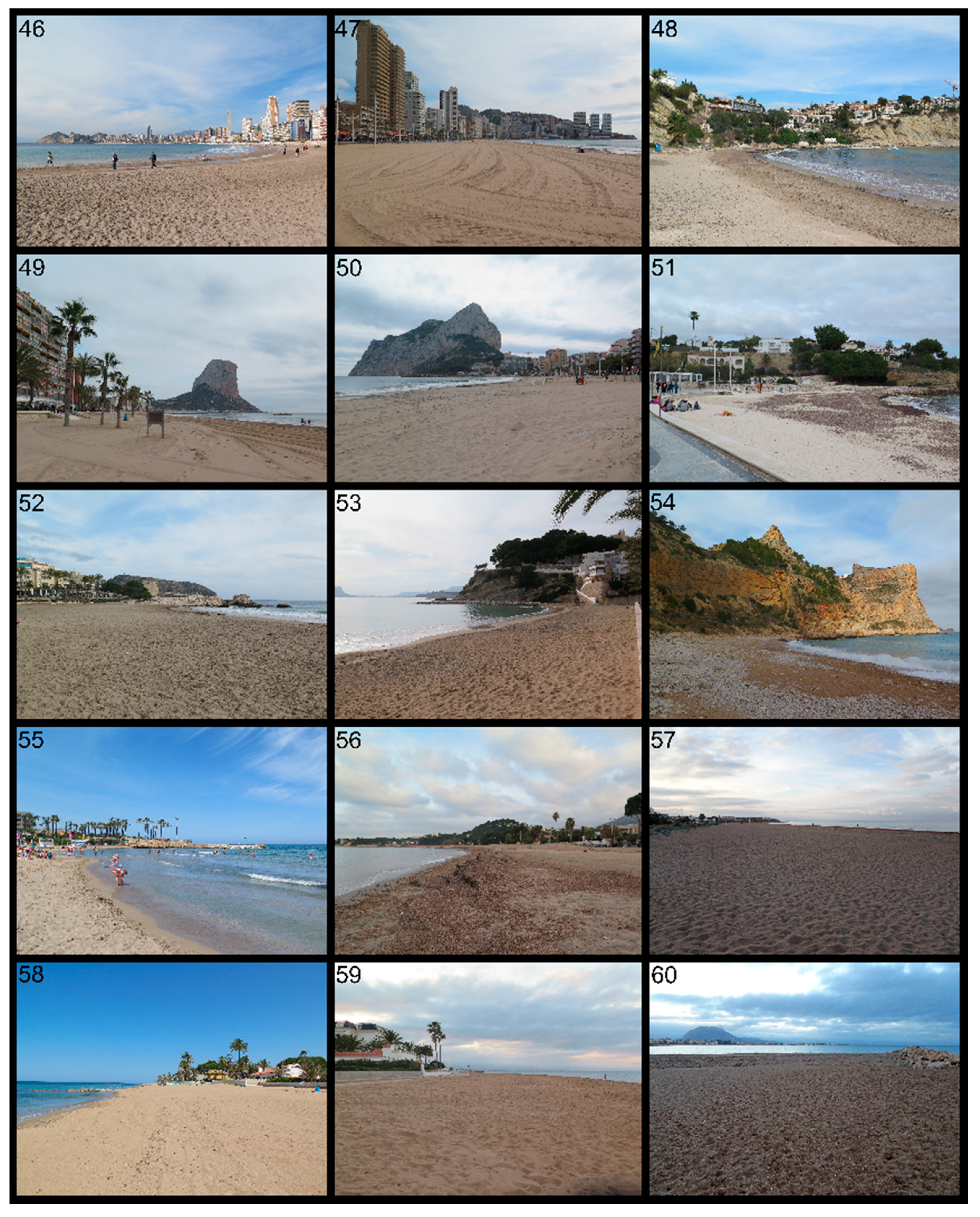
| 44–46 | Ponent | Benidorm | Urban | Nourished | [47] |
| 47 | Llevant | Benidorm | Urban | Nourished | [48] |
| 48 | Port Blanc | Calp | Rural | Native | - |
| 49 | Arenal Bol | Calp | Urban | Nourished | [42] |
| 50 | La Fossa | Calp | Urban | Native | [41] |
| 51 | Cala Fustera | Benissa | Village | Nourished | [49] |
| 52 | L’Ampolla | Teulada | Village | Native | [41] |
| 53 | El Portet | Teulada | Village | Nourished | [50] |
| 54 | El Moraig | Benitatxell | Rural | Native | [34] |
| 55 | L’Arenal | Xàvia | Urban | Nourished | [51] |
| 56 | Marineta Cassiana | Dénia | Village | Nourished | [15,41] |
| 57 | Punta del Raset | Dénia | Village | Nourished | [41,42] |
| 58 | Les Marines | Dénia | Village | Nourished | [42] |
| 59 | Les Bovetes | Dénia | Village | Native | [42] |
| 60 | Molins i Palmeres | Dénia | Village | Native | [42] |
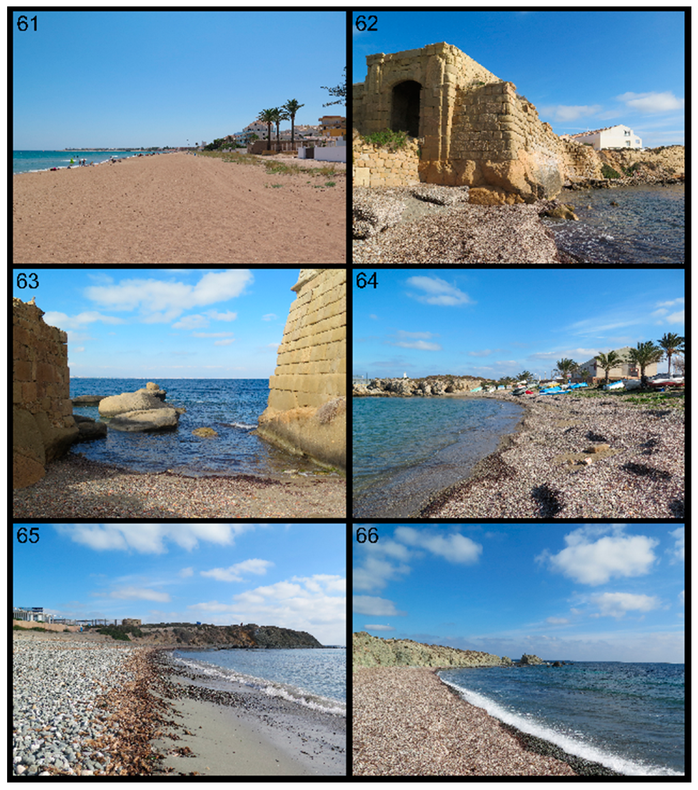
| 61 | Racó de L’Alberca | Dénia | Village | Native | [42] |
| 62 | Porta O (Sud) | Alicante | Rural | Native | [34,52] |
| 63 | Porta O (Nord) | Alicante | Rural | Native | [34,52] |
| 64 | Port Vell | Alicante | Rural | Native | [34,52] |
| 65 | Tabarca | Alicante | Rural | Native | [34,52] |
| 66 | Platja Gran | Alicante | Remote | Native | [34,52] |
| Remote | Rural | Village | Urban | Total | |
|---|---|---|---|---|---|
| Nourished | 0 | 2 | 6 | 24 | 32 |
| Native | 5 | 12 | 7 | 10 | 34 |
| Total | 5 | 14 | 13 | 34 | 66 |
| L* | a* | b* | Leucocratic Components | Melanocratic Components | |
|---|---|---|---|---|---|
| Min. | 40.16 | −1.470 | 5.82 | 8.08 | 27.74 |
| Median | 56.44 | 3.400 | 13.04 | 39.30 | 60.70 |
| Mean | 55.48 | 3.452 | 13.04 | 38.23 | 61.77 |
| Max. | 70.75 | 6.400 | 18.82 | 72.26 | 91.92 |
| Sample | L* | a* | b* | ΔL* | Δa* | Δb* |
|---|---|---|---|---|---|---|
| San Juan II (2019 year.) | 57.76 | 3.03 | 10.86 | 3.85 | 1.15 | 5.84 |
| San Juan (1989 year.) | 61.61 | 4.53 | 16.70 |
© 2020 by the authors. Licensee MDPI, Basel, Switzerland. This article is an open access article distributed under the terms and conditions of the Creative Commons Attribution (CC BY) license (http://creativecommons.org/licenses/by/4.0/).
Share and Cite
Asensio-Montesinos, F.; Pranzini, E.; Martínez-Martínez, J.; Cinelli, I.; Anfuso, G.; Corbí, H. The Origin of Sand and Its Colour on the South-Eastern Coast of Spain: Implications for Erosion Management. Water 2020, 12, 377. https://doi.org/10.3390/w12020377
Asensio-Montesinos F, Pranzini E, Martínez-Martínez J, Cinelli I, Anfuso G, Corbí H. The Origin of Sand and Its Colour on the South-Eastern Coast of Spain: Implications for Erosion Management. Water. 2020; 12(2):377. https://doi.org/10.3390/w12020377
Chicago/Turabian StyleAsensio-Montesinos, Francisco, Enzo Pranzini, Javier Martínez-Martínez, Irene Cinelli, Giorgio Anfuso, and Hugo Corbí. 2020. "The Origin of Sand and Its Colour on the South-Eastern Coast of Spain: Implications for Erosion Management" Water 12, no. 2: 377. https://doi.org/10.3390/w12020377