Article

Water-Exchange Response of Downstream River–Lake System to the Flow Regulation of the Three Gorges Reservoir, China

1
College of Resources and Environmental Science, South-central University for Nationalities, Wuhan 430074, China
2
China Institute of Water Resources and Hydropower Research, Beijing 100038, China
3
College of Hydropower & Information Engineering, Huazhong University of Science & Technology, Wuhan 430074, China
4
Key Laboratory of Water Cycle and Related Land Surface Processes, Institute of Geographic Sciences and Natural Resources Research, Chinese Academy of Sciences, Beijing 100101, China
5
Bureau of hydrology, Changjiang water resources Commission, Wuhan 430010, China
6
Guangzhou Institute of Geography, Guangzhou 510070, China
7
Tianjin Research Institute for Water Transport Engineering, Tianjin 300456, China
*
Author to whom correspondence should be addressed.
Water 2019, 11(11), 2394; https://doi.org/10.3390/w11112394
Submission received: 3 September 2019 / Revised: 17 October 2019 / Accepted: 11 November 2019 / Published: 15 November 2019
(This article belongs to the Special Issue Addressing the Environmental Impacts of Hydropower)

Abstract

:
Hydrological regime changes in the river–lake system and their influences on the ecological environment downstream dams have attracted increasingly more attention all over the world. The Dongting lake downstream of the Three Gorges Dam (TGD) in the Yangtze River has been experiencing a series of hydraulic and hydrological changes over the last decade. The hydrological and ecological influences of the TGD flow regulation on the Dongting river–lake system and its functional mechanism during the impounding periods remain extremely unclear. This study examines the hydrological changes in the Dongting river–lake system based on a 1D/2D coupled hydrodynamic model. In particular, the inflow boundary of the model with and without the TGD was applied with the outflow and inflow of the TGD, respectively, during the same regulation periods. The results show that the diverted flow from the Yangtze River into the Dongting lake and outflow from the lake back to the river drastically decreased during the impounding periods, especially in October. The decreased water exchange between the Yangtze River and the Dongting lake impaired the water residence capacity to some extent in the lake. Stage decrease in the lake area resulted in a significant reduction in the water volume of the Dongting lake with the same time percentage. In addition, the obvious drainage effect in Dongting lake due to the increased stage difference and current speed after the TGD operation was the essential cause of hydrological changes in the lake area. These results provide an improvement in the understanding of impoundment influences on the large river–lake system and give some practical information for ecological environment management in similar river–lake systems.

1. Introduction

Lakes, as one kind of the most important water providers, widely exist on the earth. Most of these lakes connect with some rivers, so the river–lake system is the common form in natural basins [1,2]. A fifth of the world’s surface freshwater was held in the five Great Lakes and their connecting rivers in North America [3]. Other lakes such as Saimaa Lake in Finland, Peace-Athabasca Delta system in Canada, and Tonle Sap Lake in Cambodia, as part of the river–lake system, provide adequate water to their adjoining residents [4,5,6]. Lakes in the river–lake system receive and store plenty of water from storms and floods during flood seasons and release it steadily; this plays a significant role in flood control for the downstream rivers, as well as the nutrient substance and part of sediment deposited in the lake area while the water flows through a lake. Therefore, lakes in a river–lake system provide the necessary elements for plant growth and the important habitats for wildlife [7].
However, with the intensification of anthropogenic activities, the health of the river–lake system also faces many challenges. There are increasingly more pollutant loads in lakes all over the world, owing to the extensive human activities [8,9,10,11,12]. More important, a series of dams in upstream channels drastically changed the hydrological regime of a river–lake system located in the middle and lower part of catchments [13,14,15]. Therefore, significant water-exchange variations occurred in the river–lake system during different reservoir-impounding periods. Consequently, water-resource utilization, waterway maintenance, ecological conservation, and water environmental management in lakes are affected to some extent [16,17,18].
The Yangtze River, as the third longest river, contributed a lot to the integrated utilization of water resources in China [19,20]. Water-resource development based on cascade reservoirs in the Yangtze River basin has achieved great progress over the past 50 years, especially in regard to the construction of the Three Gorges Dam (TGD) [21,22,23]. However, a series of hydrological and hydraulic changes inevitably occurred in the downstream channels [24,25]. Therefore, the Dongting river–lake system, 260 km downstream of the TGD, suffered from severe hydrological variations during the different flow regulation periods. Increasing attention has been attracted to the hydrological changes in the Dongting river–lake system in recent years. Hayashi et al. simulated the daily runoff processes based on an integrated catchment model in the Yangtze River basin and examined the hydraulic effect of the mainstream on the outflow of the Dongting lake; the results showed a good agreement of hydrologic budget between the observed and simulated ones [26,27]. Lai et al. [28] quantified the impoundment effects of the TGD during the dry seasons, based on a coupled model, and came to the conclusion that the extremely low water level that occurred downstream of the TGD principally resulted from the reduced inflow to the Yangtze River basin and the precipitation decrease. Wang et al. recently confirmed Lai et al.’s results again and quantified the influence of human water consumption on the last decadal lake stage decline [29]. These studies significantly contributed to revealing the hydrological changes in the Dongting river–lake system. However, more work should be done to quantify the changes in the outflow volume from the Dongting lake to the Yangtze River channels and its functional mechanism.
The evaluation of hydrological changes in the Dongting river–lake system has been carried out so far from different perspectives based on various kinds of methods. Jiang et al. [30] investigated the flood response to polder restoration in Dongting lake and explored the formation mechanism of frequent flood disasters after the TGD operation, which provided vital insights into the lake ecosystem restoration downstream of dams. Using the measured hydrological data before and after the operation of the TGD, Chang et al. [31] conducted an evaluation of the influences of the TGD during its initial operation periods and quantified the annual average changes in flow and sediment discharge in the river–lake system, which provided a scientific basis for optimizing the operation program of the Three Gorges Reservoir. Sun et al. [32] examined the topographical changes downstream of TGD and analyzed its influences on the hydrological cycle around the Dongting lake basin based on the BP neural networks. The results indicated that the inundation patterns of the lake wetlands have been changing since the TGD operation. In addition, combining the observed field and remote sensing data and hydrodynamic models, Liu et al. [33] found that the TGD resulted in great downstream landscape changes, which significantly contributed to the Dongting shrinkage and its severe drought. Therefore, physically mathematical models were highly effective means to examine the hydrological changes in the complex river–lake system.
Despite several attempts that have been made to reveal the hydrological changes that occurred after the TGD operation, some problems remain unclear regarding the TGD impoundment impact on the Dongting river–lake system and their hydrodynamic mechanism of this system. In particular, whether the lake outflow during the impounding periods is increasing or not has not drawn a definitive conclusion. Current research was mainly focused on the TGD impoundment impact by comparing with hydrological data series and the fluvial processes before and after the TGR operation; little information has been provided about the different influences of the TGD inflow and outflow processes on the downstream river–lake system, let alone the studies on the root cause analysis for the hydrological variations. The research objectives of this paper are to (1) examine the changes in the water exchange with and without the TGD and to evaluate the variation in water retention capacity of the Dongting lake based on a 1D/2D coupled hydrodynamic model; (2) analyze the variations in the lake level and water volume during the impounding periods after the operation of the TGD; and (3) further explore the formation mechanism and its dominant factors of the hydraulic and hydrological changes in the river–lake system, which will be significantly conductive to relieve the adverse influences on the river–lake system.

2. Materials and Methods

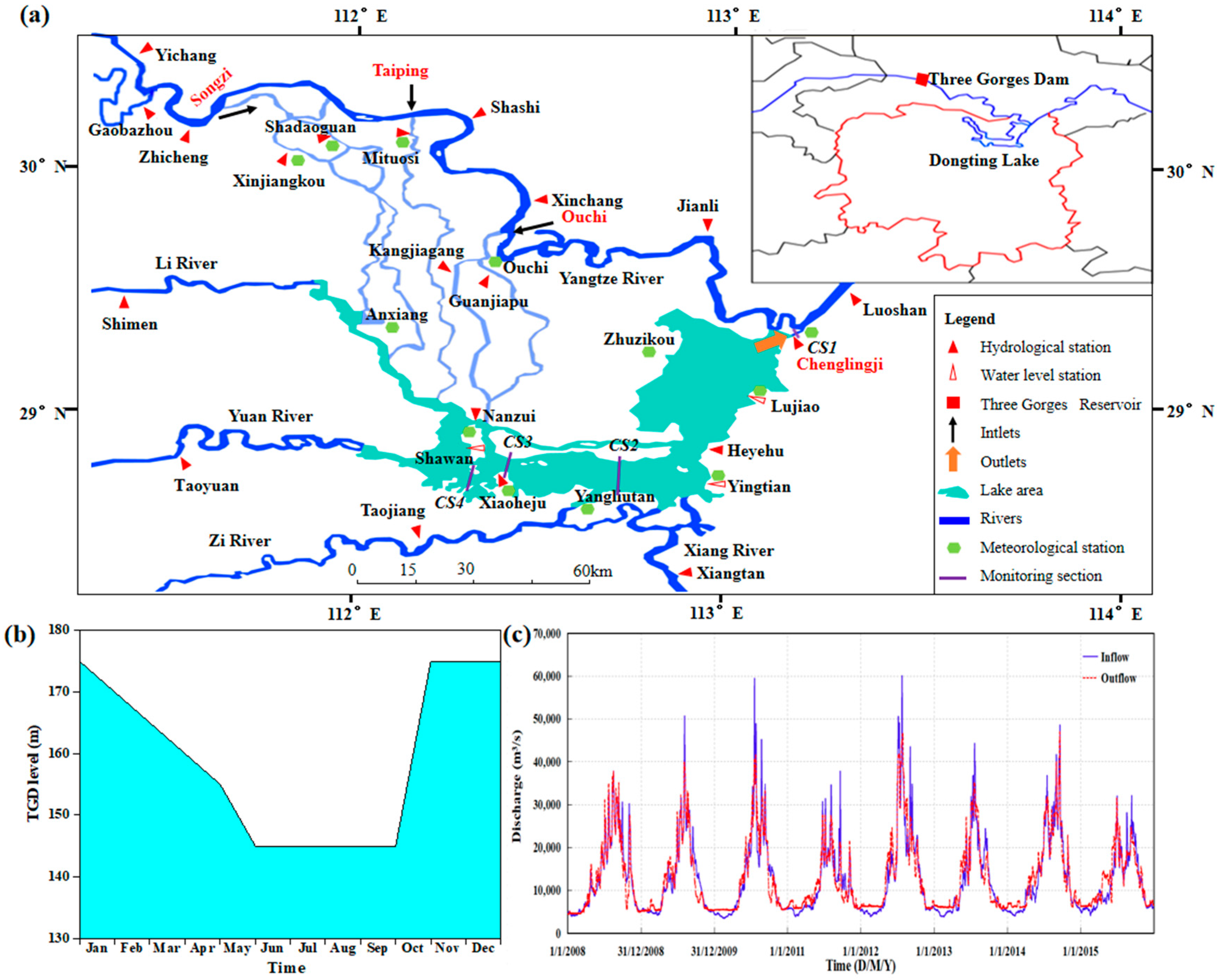
2.1. Study Area and Data

The Yangtze River, located in South Central China, is 6300 km long and ranks as the third longest river on the earth. The TGD in the middle Yangtze River was completed in 2003, and it is the largest dam structure in the world. One of the most important objectives of the TGD was the flood control in the Yangtze river basin. Therefore, significant hydrological changes occurred downstream of the TGD [34]. Dongting lake, situated downstream of the TGD (111°19′–113°34′ E, 27°39′–29°51′ N) with a drainage area of 2579 km2, is the second-largest freshwater lake in China (Figure 1). The Dongting lake was mainly fed by the Yangtze River through three inlets (Ouchi, Taiping, and Songzi) and four tributaries (Zi River, Yuan River, Xiang River, and Li River,). In addition, the lake empties its water through the Chenglingji outlet (Figure 1). The climate of the lake area is characterized by hot summers and relatively mild winters, which belongs to the subtropical monsoon climate. Its annual precipitation ranges from 1100 to 1400 mm, and the wet seasons are from May to October.
According to the operation rules of the TGD, the complete run cycle was divided into four continuous flow regulating periods: (1) flood pre-discharged regulation, emptying the reservoir volume to the downstream during this period; (2) flood regulation, the floods from the upstream were regulated during this period; (3) reservoir impoundment, partial water inflow was stored in the reservoir; and (4) water supplement, the reservoir increased its outflow to the downstream in order to meet irrigation water needs and keep the ecological balance and water depth of the waterways [35]. The above operational procedure is repeated year by year. The reservoir impoundment generally began from September to October, after the main flood seasons. The water-holding capacity test of the TGD was completed in 2008, and then normal flow regulation was carried out. Figure 1 presents the inflow and outflow processes of the TGD from 2008 to 2015.
For a comparative analysis of hydrological and hydrodynamic changes in the Dongting river–lake system, the meteorological and hydrological data (e.g., water level, discharge, precipitation, and evaporation) were collected from the Bureau of Hydrology, Changjiang Water Resources Commission, and the Weather Bureau of China. In addition, the outflow and inflow data of the TGD were collected from the Three Gorges Corporation, China. The meteorological and hydrological data cover the concerned sites in this study area. The detailed locations of the gauging stations are presented in Figure 1. Moreover, the digital elevation model including rivers and lake terrain used in this study was surveyed from 2008 to 2012, which was also provided by the Changjiang Water Resources Commission (see Supplementary Materials).

2.2. 1D/2D Coupled Hydrodynamic Model

A 1D/2D coupled model constructed by Zhang et al. [36] was used to examine the hydrological impact of the TGD on the Dongting river–lake system during the water impoundment periods. The coupled model was set up based on the module of MIKE FLOOD, which is an integrated modeling and analysis platform developed by the Danish Hydraulic Institute (DHI) and extensively applied around the world [37,38,39,40]. The 1D/2D coupled model used in this study covered the Dongting lake and the connected branches in the middle Yangtze River [36]. The river network in the study area was modeled by using the MIKE 11 hydrodynamic module, while the MIKE 21 hydrodynamic module was applied to simulate the lake area. There were 862 cross-sections, and 23,436 grid cells in the 1D and 2D hydrodynamic modules respectively. The MIKE 11 and MIKE 21 hydrodynamic modules are described by the Saint-Venant equations and the 2D shallow-water equations, respectively [41,42]. The standard linkage in the MIKE FLOOD was used in this study to connect the hydrodynamic modules; thus, water exchanges between the modules occurred through the overlapped MIKE 21 grid cells and the MIKE 11 network. Therefore, the hydrodynamic processes of the Dongting river–lake system during the impounding periods were simulated by using the coupled model in this research.
The daily streamflow gauged at the tributary gauging stations (Gaobazhou, Taojiang, Taoyuan, Shimen, and Xiangtan) was specified as the upstream boundary conditions for the coupled model, while the regular inflow and outflow of the TGR were applied as the mainstream boundary conditions. The downstream boundary condition was applied as the rating curve at the Luoshan station. Zhang et al. [36] calibrated and validated the coupled model against the observed data in the study area for the periods of January–December 2008 and January–December 2011, respectively. The coupled model was quantitatively evaluated by using the Nash–Sutcliffe efficiency coefficients (NSE) and the normalized root mean squared error (RMSE); the results show that there is a fairly close agreement between the simulated and observed values at the main stream, tributaries, and the lake area. The NSE value is larger than 0.89 and RMSE is smaller than 0.025 at the river–lake system stations, which indicates that the coupled model has a high simulation accuracy to predict and evaluate the hydrological changes in the study area [36].

2.3. Hydrologic Residence

To eliminate the effects of data random fluctuation on the research results, the gauged stage and water volume data in the lake area were processed by using the moving average method, as follows:
h ( y )   =   1 5 t = 1 5 H ( y , t )
v   ( y )   =   1 5 t = 1 5 V ( y , t )
where h ( t ) and v ( t ) are the data series of moving averaged stage and water volume, respectively, which are the results of a daily averaged sequence of H(y,t) and V(y,t); y and t denote the year and day in the time series.
The fluctuation of stage and water volume in the lake was on account of the flow difference between the lake inflow and outflow. Therefore, the ratio between the volume difference and the inflow volume was used to show the water residence rate as follows:
R r e s i = ( q i n ( t ) q o u t ( t ) ) d t q i n ( t ) d t
where R r e s i is the water residence rate (WRR) in the lake; q i n (t) and q o u t (t) are the daily water inflow and outflow rate of the Dongting lake.
In addition, the residence time is an important variable to present the hydrological changes in the study area, which can be addressed as follows:
T r e s i = t q o u t ( t ) d t q o u t ( t ) d t ,   ( q i n > q o u t )
where T r e s i is the mean residence time (MRT), which is the cumulative time that inflow is larger than the outflow.

2.4. Evaluation of Hydrologic Regime Changes during the Impounding Periods

To accurately quantify the influence of the TGD impoundment on the river–lake system, the following two research scenarios were performed: Scenario 1 (S1), simulating the actual hydrological processes under the TGD regulation during 2008–2011; Scenario 2 (S2), simulating the hydrological processes that without the operation of the TGD during the same periods. For the second scenario (S2), the flow boundary at the Yichang station was replaced by the upstream inflow of the TGD. The other boundary conditions were kept the same as scenario 1. The gauged estuary station data of the tributaries (Xiang River, Zi River, Yuan River, and Li River) were applied as the inflow boundary conditions to the lake area. Several complete scheduling cycles were covered in the selected simulation periods; therefore, the hydraulic and hydrological changes during the different run phases of the TGD can be detected by comparing the two simulation scenarios.

3. Results

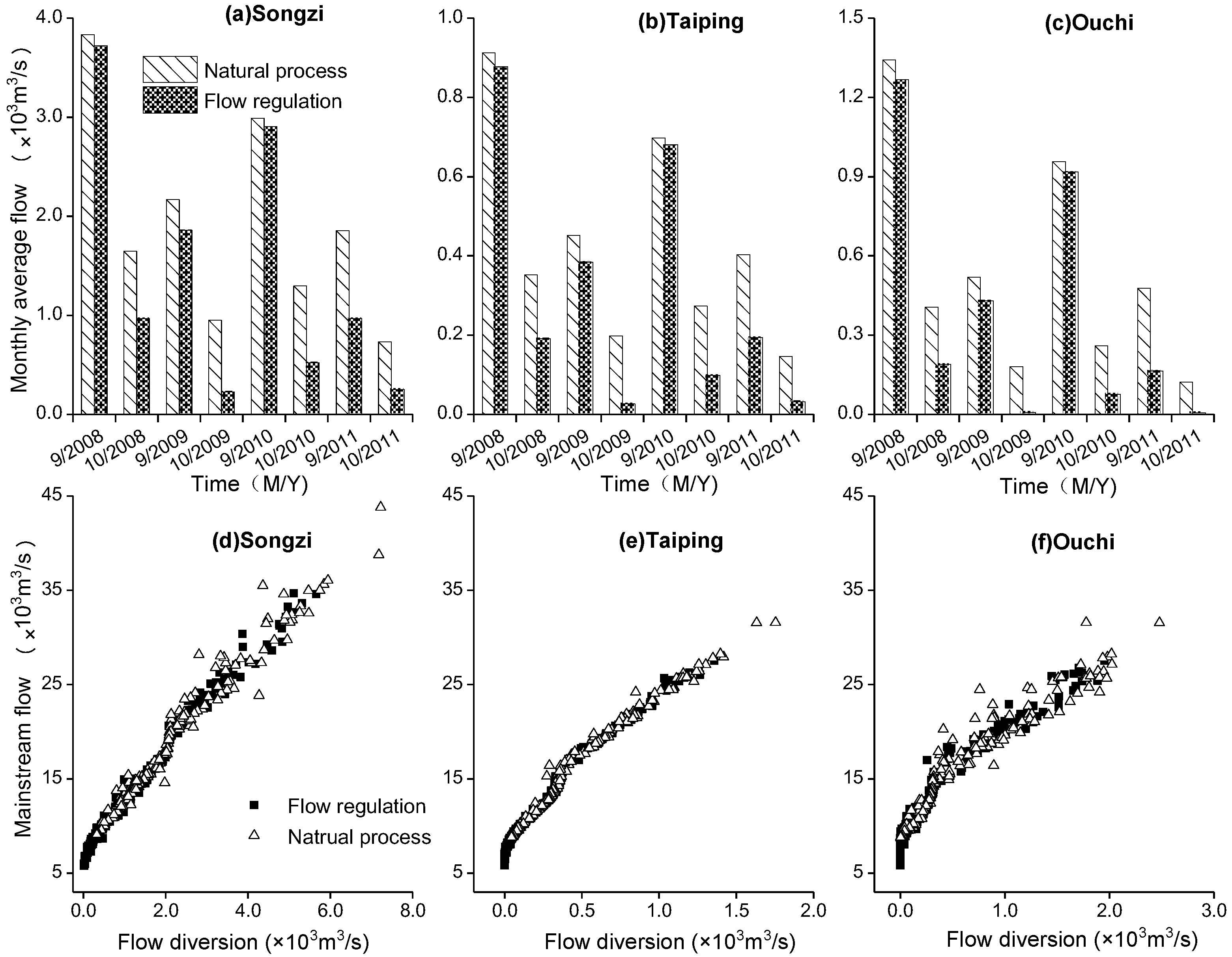
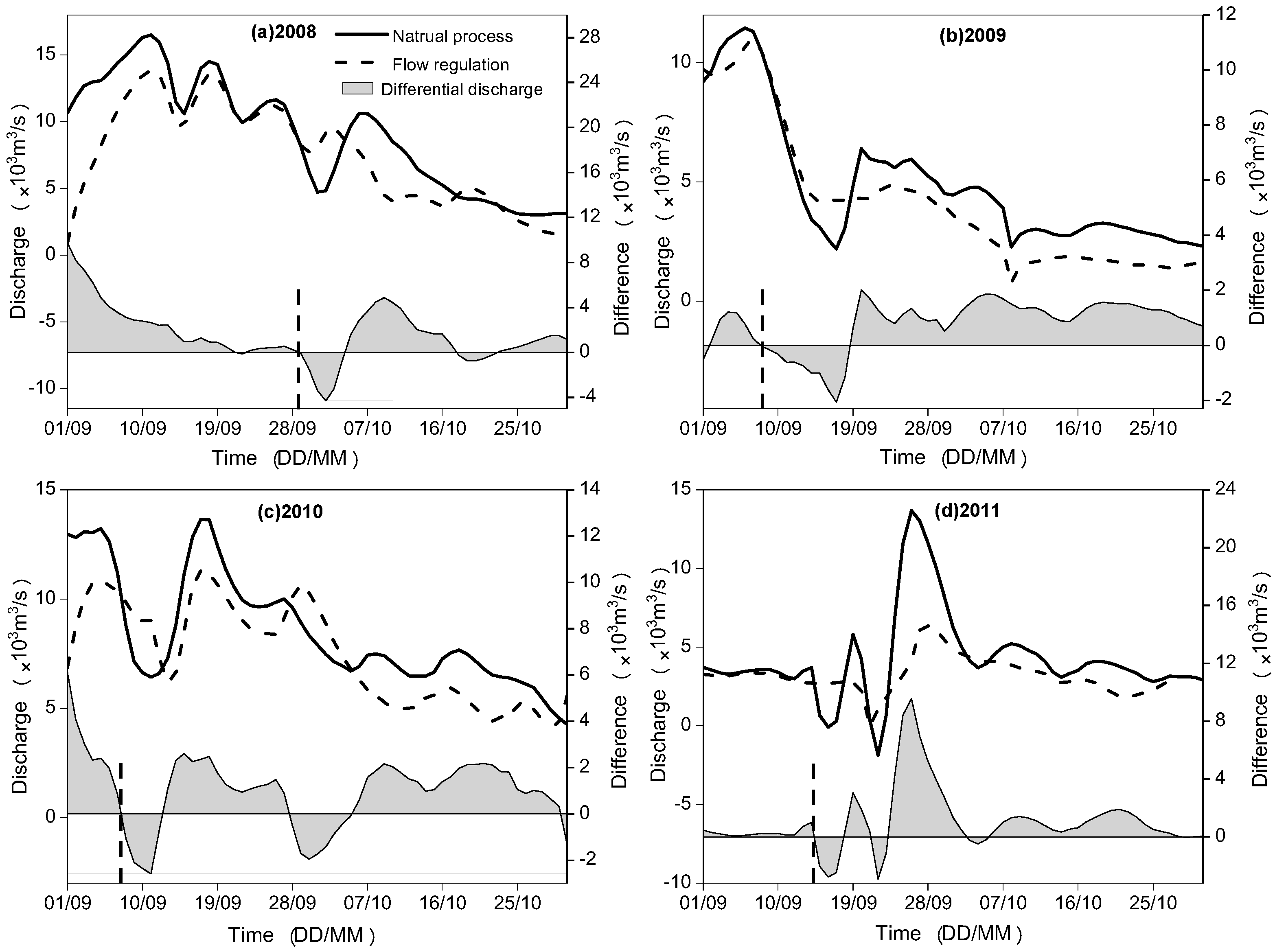
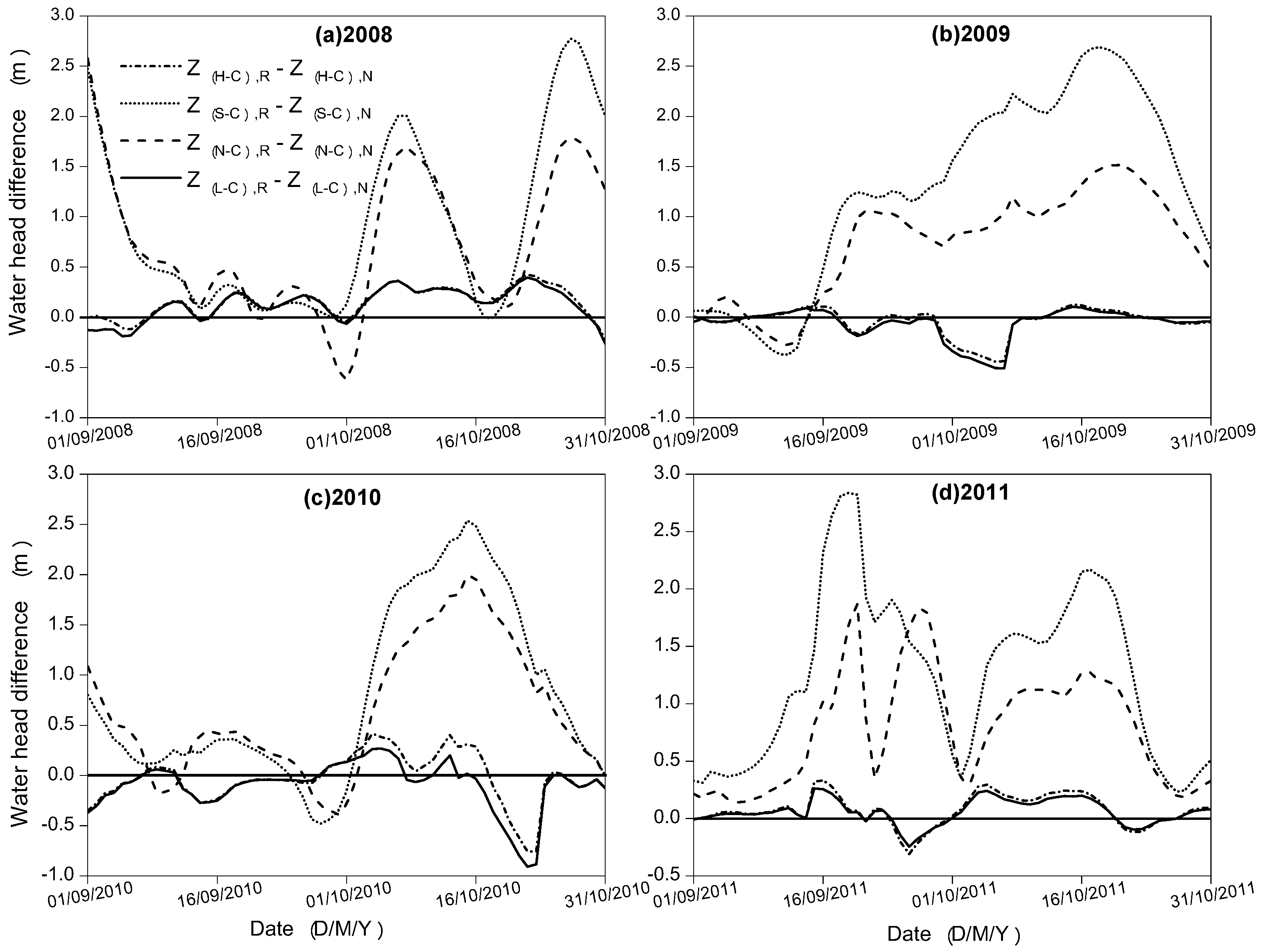
3.1. Water Exchange between the Dongting Lake and the Yangtze River

There were obvious hydrological variations after the TGD was put into operation; as shown in Figure 2, the diverted flow through the Taiping, Songzi, and Ouchi inlets to the tributaries dropped obviously. Compared with the flow changes in September, the flow drop occurred much more seriously during October due to the increasing water impoundment of the TGD. The mean diverted flow through the three inlets was less than 1000 m3/s during October, after the TGD operation. The flow drop was most serious at the Ouchi inlet, which was nearly drying up during the October 2009 and 2011. In addition, there was a high agreement between the mainstream flow and the diverted flow during the impoundment periods at the three inlets of the tributaries with and without the TGD. Consequently, there was an evident flow drop in the mainstream and diverted flow after the TGD operation. When the flow discharge in the mainstream was lower than 4800, 7200, and 6700 m3/s, there would be no flow diversion at the Songzi, Taiping, and Ouchi inlets, respectively (Figure 2).
Figure 3 presents the outflow processes at the Chenglingji outlet during September and October, from 2008 to 2011, with and without the TGD, which indicates that water impoundment of the TGD indeed leads to a series of hydrological changes in the lake outflow. Although there were both a flow increase and a flow decrease after the TGD operation, the flow decrease was more apparent on the whole compared with the processes without the TGD. During the periods of TGD impoundment from September to October in each year from 2008 to 2011, the maximum flow decrease was up to 4860, 2012, 2610, and 9551 m3/s, and the mean flow decrease was about 1610, 790, 1029, and 1035 m3/s than the processes without TGD. Furthermore, the dashed lines in Figure 3 present the beginning day that the TGD impoundment. There was a sharp increase in the lake outflow when the TGD began to store water. But then the outflow reduced sharply because of the water volume decrease in Dongting lake.
In addition, the flow difference between lake inflow and outflow directly caused the water exchange variation in the river–lake system. Therefore, the water volume and its residence time in the lake area unavoidably changed with the water exchange. The water residence rate and mean residence time was calculated via Equations (3) and (4), and the results were presented in Table 1. The water residence rate indicates the water retention capacity of the Dongting lake; as shown in Equation (3), its negative value implies the outflow is larger than the inflow. Although there was an evident decrease in the inflow and outflow from September to October, the water residence rate under the TGD regulation was smaller than the one without TGD, which indicated the water volume gap between the lake inflow from the Yangtze River and the lake outflow to the Yangtze River increased after the TGD operation. The inflow decrease was larger than the outflow decrease after the TGD operation. Consequently, the mean residence time was also reduced due to the decreased water retention capacity. As shown in Table 1, there were about 1–2 days reduced in the water residence time after the TGD operation.

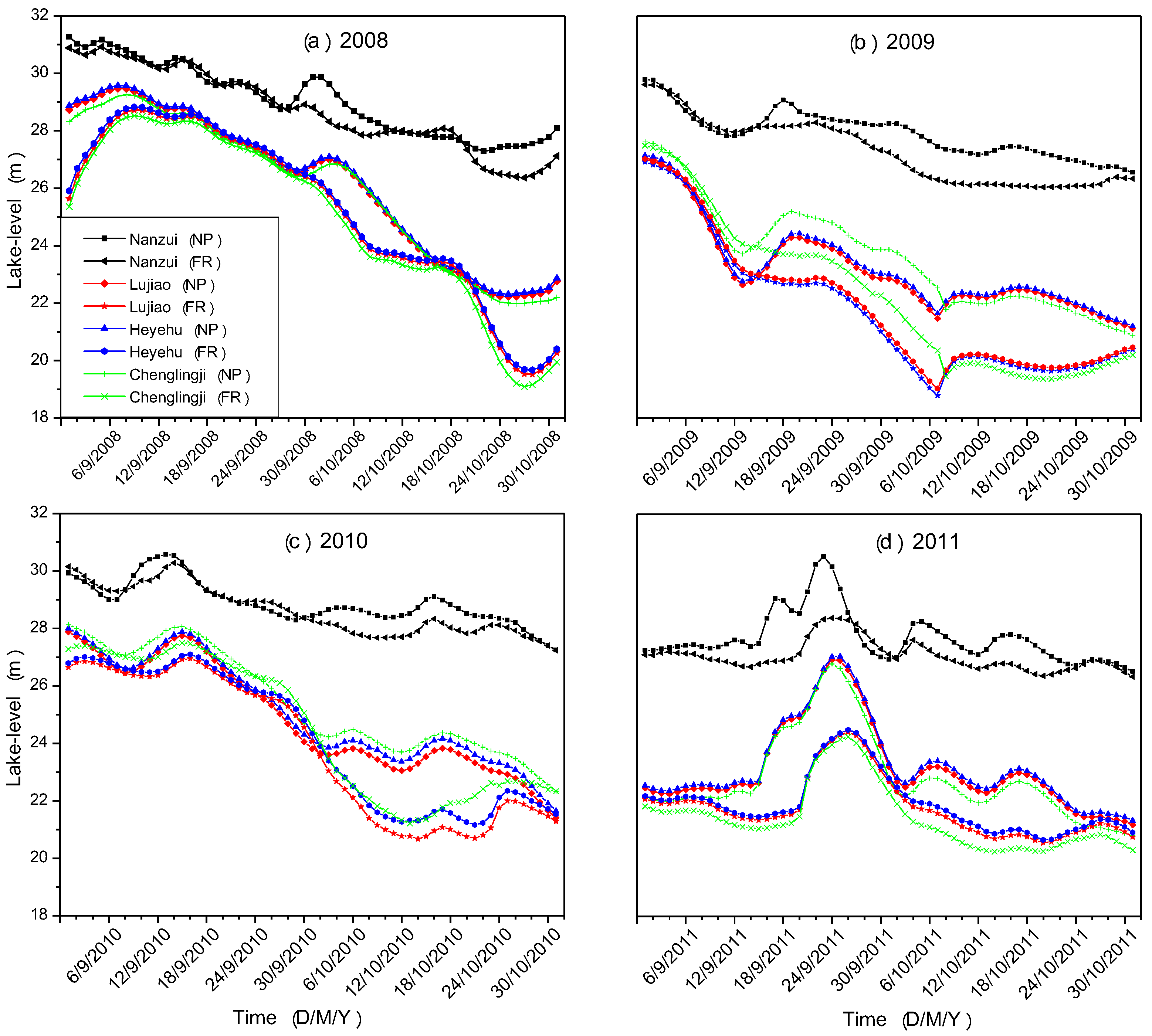
3.2. Changes in the Hydrological Regime of the Dongting Lake

The changes of water exchange between the Dongting lake and the Yangtze River inevitably lead to the variation in the hydrological regime of the Dongting lake. Figure 4 shows the lake-stage changes from September to October, with and without the TGD. The water level decreased apparently at all the gauging stations during the same periods. The stage difference at the Nanzui station was more insignificant than the other lake stations. In addition, there was a similar stage-changing trend at the Heyehu, Lujiao, and Chenglingji stations. Compared with the processes without TGD, the lake level decreased greatly from late September, after the TGD impoundment. The maximum and mean lake level decrease at the Nanzui station was 2.18 and 0.46 m during the impounding periods from 2008 to 2011. Similarly, there was a larger-lake level decrease at the other stations, especially at the Chenglingji station. The maximum lake-level decrease occurred at the Chenglingji station and was up to 3.39 m, and the mean lake-level decrease at the Heyehu, Lujiao, and Chenglingji stations was about 1.17, 1.19, and 1.20 m.
Figure 5 presents the stage-change rate in the lake area. The stage change rate was the daily mean water level variation from September to October. As shown in Figure 5, the stage drop under the TGD flow regulation from September to October was more severe than the one in the processes without TGD. After the TGD operation, the lake level decreased about 0~0.6 m per day, while the stage drop was only 0~0.45 m per day in the processes without TGD. It should be noted that the flood regulation of the TGD before the impoundment periods had also some influences on the stage change rate. The peak-flow reduction during the flood periods (from July to August) drastically decreased the flow diversion to the Dongting lake, which had an influence on the lake-level changes to some extent. For this reason, the stage-change rate in 2011 under the TGD operation was slightly smaller than the one without TGD.
Water exchange in the river–lake system also had a direct impact on the water volume in the lake area. The relationship between the water volume of the Dongting lake and the stage at the Chenglingji outlet from September to October was shown in Figure 6. The Chenglingji outlet is situated at the lowest lake site, and its stage changes greatly depended on the lake volume. Therefore, the relationship shown in Figure 6 showed the volume changes due to the water exchange in the Dongting river–lake system. The water volume decreased more or less after the TGD operation, especially during the impoundment periods in 2011. The decrease in the smallest lake volume during the impounding periods was about 3.61 × 10⁹ m3, 1.47 × 10⁹ m3, 0.93 × 10⁹ m3, and 0.63 × 10⁹ m3 in each year, from 2008 to 2011, which contributed a lot to the severe drop of lowest lake level in the Dongting lake.
The impoundment impact on the water volume of the Dongting lake was not instantaneous but lasted all the impounding periods. As shown in Figure 7, compared with the processes without TGD, there was a significant decrease in the water volume during most time periods under the TGD flow regulation from September to October. The mean water-volume decrease with the time percentage from 50%–80% was about 3.32 × 10⁹ m3, 3.27 × 10⁹ m3, 3.72 × 10⁹ m3, and 2.05 × 10⁹ m3 in each year, from 2008 to 2011. In addition, the water volume with the largest time percentage of the Dongting lake was still smaller than the one during the same periods of processes without TGD, which resulted from the drastic water exchange between the Dongting lake and the Yangtze River. The TGD impoundment not only increased the outflow from the Dongting lake but also seriously decreased the inflow to the lake area.
Flow-field variation inevitably occurred due to the variations in lake level and water volume in the lake area. Figure 8 presents the flow velocity variations at the gauging stations of lake area, with and without the TGD. The changes in the flow velocity did not maintain consistency, because of the complicated hydraulic relation in the great lake area. The mean flow velocity at the Chenglingji, Lujiao, Heyehu stations increased to some extent after the TGD operation, while mean flow velocity reduced at the Shawan and Nanzui stations, to a different degree, with an especially drastic decrease at the Nanzui station. The maximum velocity increase, about 0.067 m/s in 2008, occurred at the Chenglingji outlet of the eastern part of the Dongting lake. There was a high agreement of current speed variation between the Lujiao and Heyehu stations. On the contrary, the maximum velocity decrease at the Nanzui station was about 0.128 m/s in 2009.

4. Discussion

Impoundment of the TGD reduced the outflow to the downstream during its impounding periods, which had a complex influence on the hydraulic interaction between the Yangtze River and the Dongting lake. There was a positive correlation between the mainstream flow and the diverted flow at the three inlets of the Dongting lake (Figure 2). The reduced outflow from the TGD significantly decreased the diverted flow during impounding periods, which contributed a lot to the volume reduction of the lake area. Moreover, there was an evident stage decrease at the Chenglingji lake outlet that resulted from the reduced flow discharge in the Yangtze River. As presented in the Figure 9, the water-head difference increased to a different degree after the TGD was put into operation; there was especially a larger water-head difference between the eastern and western part of the Dongting lake, e.g., the maximum water-head difference was much higher than 1.5 m between the Chenglingji and Nanzui (Shawan). It was the very reason that the outflow from the Chenglingji outlet had a transitory increase at the beginning of TGD impoundment. However, limited to the water volume and the rapid stage reduction in the lake area, the lake outflow significantly decreased subsequently (Figure 3, Figure 5 and Figure 7).
On the other hand, the decrease in the water volume and lake level of Dongting lake also had an impact on the hydrological regime of the Dongting river–lake system. Lacking adequate water supply, the Dongting lake provided much less water to the downstream channels to maintain the water depth of the waterway in the following dry seasons [43]. The increased volume gap between the inflow and outflow of the Dongting lake contributed greatly to the low stage of the lake area. Furthermore, the decrease in the lake level and water volume greatly changed the hydrodynamic conditions in the lake area, which were precisely necessary conditions for the migration and transformation of nutrient content in the lake flow [44]. The abrupt hydrological changes during the impoundment periods were extremely adverse to the stability of the lake ecological environment, e.g., the 1–2 days difference in residence time indicated the time decrease that the lake inflow from the Yangtze River was larger than the lake outflow to the Yangtze River, which means the aquatic environment of the Dongting lake changed acutely within two months impoundment periods. The increased water head between the stations contributed to the increase in the flow velocity and shorting the water cycle duration, which reduced the risk of water eutrophication in the lake area. The water-head difference near the lake outlet resulted in an increase in the hydraulic gradient, which significantly contributed to the velocity increase in the eastern lake area. It is well-known that enough current speed is the necessary hydrodynamic conditions for nutrient transport. Therefore, the ecological environment will be influenced by the velocity variation in the eastern Dongting lake area. In addition, the change of the hydrological regime did not show well consistent among subareas of the lake due to the complicated hydraulic relationship in the river–lake system. Therefore, the influencing mechanism of the reservoir impoundment to the river–lake system should be further researched. It should be noted that this study examined the impoundment impact, but the other influence factors remain unchanged. The inflow and outflow of the TGD, as the flow boundary conditions in the model research, more directly revealed the impoundment impact on the river–lake system. In spite of some results that have been achieved based on the effective analysis in this paper, more research on the influence of other factors is still worth carrying out.

5. Conclusions

Impoundment impact, generally, is one of the most important influence factors to the hydrological regime of the river basin. In this study, a physically coupled hydrodynamic model and extensive hydrological data were combined to quantify the impoundment influences on the Dongting river–lake system. The TGD inflow and outflow, as the upstream flow boundary conditions, were the first attempt to explore the impoundment impact in the large Dongting river–lake system, which provided insights into the changes in the hydrological regime. The results revealed that water volume and lake level in the lake area decreased to a different degree under the flow regulation of the TGD, which resulted from the water-exchange changes in the river–lake system. The water inflow to the Dongting lake drastically decreased in total during the impounding periods of the TGD, which not only resulted in a great reduction in water volume and lake stage in the Dongting lake but also decreased the outflow to the downstream channels.
In addition, compared with the different upstream flow conditions for the coupled hydrodynamic model, the impoundment impact on the hydraulic interaction between the Yangtze River and the Dongting lake during the impounding periods was examined. The results implied that the flow velocity in the eastern part of the Dongting lake increased due to the enlarged water head to the lake outlet. However, the flow velocity decreased in the western lake area due to the drastic inflow reduction from the mainstream and the weak hydraulic relationship between the western and eastern parts of the Dongting lake. It indicated that the hydraulic and hydrological regime in the Dongting river–lake system was complicated, which also had some other influence factors worthy of further investigation.
Moreover, the results indicated that the water residence rate decreased to some extent during the different impounding periods, which implied the water retention capacity of the Dongting lake was impaired. Consequently, the water residence time also decreased during impounding periods. This study focused on the impoundment impact on the hydrological and hydraulic regime changes in the Dongting river–lake system and allowed us to better understand the potential influences of the changes in the water exchange after the TGD operation. Finally, the scientific knowledge derived from this study can provide a reference for the administrative departments to make a scientific and rational decision for water-resource, water–ecological, and environmental management in the similar river–lake systems.

Supplementary Materials

The model input data of the two scenarios investigated in this paper can be accessed through the following websites: http://www.cjh.com.cn and http://sw.hubeiwater.gov.cn.

Author Contributions

J.Z. conducted the modeling, performed the analysis, and drafted the manuscript; T.H. acquired, processed, and analyzed the data. L.C. conceived of and designed the study and interpreted the results; X.L. and L.F. prepared the input data for the simulations. L.Z. provided observational data and helped with the analysis; Y.Y. gave constructive comments on the results in this study. All the authors edited the manuscript.

Acknowledgments

This paper was financially supported by the National Key Research and Development Plan (2016YFC0400901) and the National Natural Science Foundation of China (51509273, 41601006, 51679094, and 51409085).

Conflicts of Interest

The authors declare that they do not have individual or collective conflicts of interest.

References

  1. Daneshvar, A.; Svanfelt, J.; Kronberg, L.; Prévost, M.; Weyhenmeyer, G.A. Seasonal variations in the occurrence and fate of basic and neutral pharmaceuticals in a Swedish river–lake system. Chemosphere 2010, 80, 301–309. [Google Scholar] [CrossRef] [PubMed]
  2. Köhler, J.; Hoeg, S. Phytoplankton selection in a river—Lake system during two decades of changing nutrient supply. In The Trophic Spectrum Revisited. Developments in Hydrobiology; Reynolds, C.S., Dokulil, M., Padisák, J., Eds.; Springer: Dordrecht, The Netherlands, 2000; Volume 150, pp. 13–24. [Google Scholar]
  3. Jackson, R.B.; Carpenter, S.R.; Dahm, C.N.; McKnight, D.M.; Naiman, R.J.; Postel, S.L.; Running, S.W. Water in a changing world. Ecol. Appl. 2001, 11, 1027–1045. [Google Scholar] [CrossRef]
  4. Karels, A.; Niemi, A. Fish community responses to pulp and paper mill effluents at the southern Lake Saimaa, Finland. Environ. Pollut. 2002, 116, 309–317. [Google Scholar] [CrossRef]
  5. Lamberts, D. The Tonle Sap Lake as a productive ecosystem. Int. J. Water Resour. Dev. 2006, 22, 481–495. [Google Scholar] [CrossRef]
  6. Prowse, T.; Beltaos, S.; Gardner, J.; Gibson, J.; Granger, R.; Leconte, R.; Peters, D.; Pietroniro, A.; Romolo, L.; Toth, B. Climate change, flow regulation and land-use effects on the hydrology of the Peace-Athabasca-Slave system; Findings from the Northern Rivers Ecosystem Initiative. Environ. Monit. Assess. 2006, 113, 167–197. [Google Scholar] [CrossRef] [PubMed]
  7. Herdendorf, C.; HBkanson, L.; Jude, D.; Sly, P. A review of the physical and chemical components of the Great Lakes: A basis for classification and inventory of aquatic habitats. In The Development of an Aquatic Habitat Classification System for Lakes; CRC Press: Boca Raton, FL, USA, 2017; pp. 121–172. [Google Scholar]
  8. Rajeshkumar, S.; Liu, Y.; Zhang, X.; Ravikumar, B.; Bai, G.; Li, X. Studies on seasonal pollution of heavy metals in water, sediment, fish and oyster from the Meiliang Bay of Taihu Lake in China. Chemosphere 2018, 191, 626–638. [Google Scholar] [CrossRef] [PubMed]
  9. Chen, L.; Singh, V.P.; Guo, S. Measure of Correlation between River Flows Using the Copula-Entropy Method. J. Hydrol. Eng. 2013, 18, 1591–1606. [Google Scholar] [CrossRef]
  10. Jeppesen, E.; Brucet, S.; Naselli-Flores, L.; Papastergiadou, E.; Stefanidis, K.; Noges, T.; Noges, P.; Attayde, J.L.; Zohary, T.; Coppens, J. Ecological impacts of global warming and water abstraction on lakes and reservoirs due to changes in water level and related changes in salinity. Hydrobiologia 2015, 750, 201–227. [Google Scholar] [CrossRef]
  11. Chen, L.; Singh, V.P.; Huang, K. Bayesian Technique for the Selection of Probability Distributions for Frequency Analyses of Hydrometeorological Extremes. Entropy 2018, 20, 117. [Google Scholar] [CrossRef]
  12. Xie, C.; Huang, X.; Mu, H.; Yin, W. Impacts of land-use changes on the lakes across the Yangtze floodplain in China. Environ. Sci. Technol. 2017, 51, 3669–3677. [Google Scholar] [CrossRef]
  13. Pokhrel, Y.; Burbano, M.; Roush, J.; Kang, H.; Sridhar, V.; Hyndman, D.W. A Review of the Integrated Effects of Changing Climate, Land Use, and Dams on Mekong River Hydrology. Water 2018, 10, 266. [Google Scholar] [CrossRef]
  14. Chen, L.; Singh, V.P.; Xiong, F. An Entropy-Based Generalized Gamma Distribution for Flood Frequency Analysis. Entropy 2017, 19, 239. [Google Scholar] [CrossRef]
  15. Grabowska, M.; Mazur-Marzec, H. The effect of cyanobacterial blooms in the Siemianówka Dam Reservoir on the phytoplankton structure in the Narew River. Oceanol. Hydrobiol. Stud. 2011, 40, 19–26. [Google Scholar] [CrossRef]
  16. Buytaert, W.; Zulkafli, Z.; Grainger, S.; Acosta, L.; Alemie, T.C.; Bastiaensen, J.; De Bièvre, B.; Bhusal, J.; Clark, J.; Dewulf, A. Citizen science in hydrology and water resources: Opportunities for knowledge generation, ecosystem service management, and sustainable development. Front. Earth Sci. 2014, 2, 1–21. [Google Scholar] [CrossRef]
  17. Jafari, N. Ecological and socio-economic utilization of water hyacinth (Eichhornia crassipes Mart Solms). J. Appl. Sci. Environ. Manag. 2010, 14, 43–49. [Google Scholar] [CrossRef]
  18. Chowdhury, N.T. Water management in Bangladesh: An analytical review. Water Policy 2010, 12, 32–51. [Google Scholar] [CrossRef]
  19. Bao, C.; Fang, C. Water resources flows related to urbanization in China: Challenges and perspectives for water management and urban development. Water Resour. Manag. 2012, 26, 531–552. [Google Scholar] [CrossRef]
  20. Chen, L.; Singh, V.P.; Guo, S.; Zhou, J.; Zhang, J.; Liu, P. An objective method for partitioning the entire flood season into multiple sub-seasons. J. Hydrol. 2015, 528, 621–630. [Google Scholar] [CrossRef]
  21. Strehmel, A.; Schmalz, B.; Fohrer, N. Evaluation of land use, land management and soil conservation strategies to reduce non-point source pollution loads in the three gorges region, China. Environ. Manag. 2016, 58, 906–921. [Google Scholar] [CrossRef]
  22. Zhang, J.; Sun, M.; Deng, Z.; Lu, J.; Wang, D.; Chen, L.; Liu, X. Runoff and Sediment Response to Cascade Hydropower Exploitation in the Middle and Lower Han River, China. Math. Probl. Eng. 2017, 2017, 8785236. [Google Scholar] [CrossRef]
  23. Dai, L.; Zhou, J.; Chen, L.; Huang, K.; Wang, Q.; Zha, G. Flood-risk analysis based on a stochastic differential equation method. J. Flood Risk Manag. 2019, 12 (Suppl. 1), e12515. [Google Scholar] [CrossRef]
  24. Zhang, R.; Zhang, S.; Xu, W.; Wang, H. Flow regime of the three outlets on the south bank of Jingjiang River, China: An impact assessment of the Three Gorges Reservoir for 2003–2010. Stoch. Environ. Res. Risk Assess. 2015, 29, 2047–2060. [Google Scholar] [CrossRef]
  25. Chen, L.; Qiu, H.; Zhang, J.; Singh, V.P.; Zhou, J.; Huang, K. Copula-based method for stochastic daily streamflow simulation considering lag-2 autocorrelation. J. Hydrol. 2019, 578, 1–9. [Google Scholar] [CrossRef]
  26. Hayashi, S.; Murakami, S.; Xu, K.; Watanabe, M.; Xu, B. Daily runoff simulation by an integrated catchment model in the middle and lower regions of the Changjiang basin, China. J. Hydrol. Eng. 2008, 13, 846–862. [Google Scholar] [CrossRef]
  27. Zhou, Q.; Chen, L.; Singh, V.P.; Zhou, J.; Chen, X.; Xiong, L. Rainfall-runoff simulation in karst dominated areas based on a coupled conceptual hydrological model. J. Hydrol. 2019, 573, 524–533. [Google Scholar] [CrossRef]
  28. Lai, X.; Jiang, J.; Yang, G.; Lu, X. Should the Three Gorges Dam be blamed for the extremely low water levels in the middle–lower Yangtze River? Hydrol. Processes 2014, 28, 150–160. [Google Scholar] [CrossRef]
  29. Wang, J.; Sheng, Y.; Wada, Y. Little impact of the Three Gorges Dam on recent decadal lake decline across China’s Yangtze Plain. Water Resour. Res. 2017, 53, 3854–3877. [Google Scholar] [CrossRef]
  30. Jiang, J.; Lai, X.; Huang, Q. The characteristics of flood responses to the restoration of polders on Dongting Lake, China. Hydrol. Sci. J. 2007, 52, 671–685. [Google Scholar]
  31. Chang, J.; Li, J.; Lu, D.; Zhu, X.; Lu, C.; Zhou, Y.; Deng, C. The hydrological effect between Jingjiang River and Dongting Lake during the initial period of Three Gorges Project operation. J. Geogr. Sci. 2010, 20, 771–786. [Google Scholar] [CrossRef]
  32. Sun, Z.D.; Huang, Q.; Opp, C.; Hennig, T.; Marold, U. Impacts and Implications of Major Changes Caused by the Three Gorges Dam in the Middle Reaches of the Yangtze River, China. Water Resour. Manag. 2012, 26, 3367–3378. [Google Scholar] [CrossRef]
  33. Liu, Y.B.; Wu, G.P.; Guo, R.F.; Wan, R.R. Changing landscapes by damming: The Three Gorges Dam causes downstream lake shrinkage and severe droughts. Landsc. Ecol. 2016, 31, 1883–1890. [Google Scholar] [CrossRef]
  34. Feng, L.; Hu, C.M.; Chen, X.L.; Zhao, X. Dramatic Inundation Changes of China’s Two Largest Freshwater Lakes Linked to the Three Gorges Dam. Environ. Sci. Technol. 2013, 47, 9628–9634. [Google Scholar] [CrossRef] [PubMed]
  35. Liu, X.; Chen, L.; Zhu, Y.; Singh, V.P.; Qu, G.; Guo, X. Multi-objective reservoir operation during flood season considering spillway optimization. J. Hydrol. 2017, 552, 554–563. [Google Scholar] [CrossRef]
  36. Zhang, J.; Feng, L.; Chen, L.; Wang, D.; Dai, M.; Xu, W.; Yan, T. Water compensation and its implication of the Three Gorges Reservoir for the river-lake system in the middle Yangtze River, China. Water 2018, 10, 1011. [Google Scholar] [CrossRef] [Green Version]
  37. Patro, S.; Chatterjee, C.; Mohanty, S.; Singh, R.; Raghuwanshi, N. Flood inundation modeling using MIKE FLOOD and remote sensing data. J. Indian Soc. Remote Sens. 2009, 37, 107–118. [Google Scholar] [CrossRef]
  38. Vanderkimpen, P.; Melger, E.; Peeters, P. Flood modeling for risk evaluation: A MIKE FLOOD vs. SOBEK 1D/2D benchmark study. In Flood Risk Management: Research and Practice; Samuels, P., Huntington, S., Allsop, W., Harrop, J., Eds.; Taylor & Francis Group: London, UK, 2008; pp. 77–84. [Google Scholar]
  39. Kadam, P.; Sen, D. Flood inundation simulation in Ajoy River using MIKE-FLOOD. ISH J. Hydraul. Eng. 2012, 18, 129–141. [Google Scholar] [CrossRef]
  40. Danish Hydraulic Institute (DHI). Hydrodynamic Module, User Guide; DHI Water & Environment: Horsholm, Demark, 2012. [Google Scholar]
  41. Danish Hydraulic Institute (DHI). MIKE 11 Flow Model: Hydrodynamic Module User Guide; DHI Water and Environment: Horsholm, Denmark, 2012. [Google Scholar]
  42. Danish Hydraulic Institute (DHI). MIKE 21 Flow Model: Hydrodynamic Module User Guide; DHI Water and Environment: Horsholm, Denmark, 2012. [Google Scholar]
  43. Lai, X.; Jiang, J.; Liang, Q.; Huang, Q. Large-scale hydrodynamic modeling of the middle Yangtze River Basin with complex river–lake interactions. J. Hydrol. 2013, 492, 228–243. [Google Scholar] [CrossRef]
  44. Qian, Y.; Liang, X.; Chen, Y.; Lou, L.; Cui, X.; Tang, J.; Li, P.; Cao, R. Significance of biological effects on phosphorus transformation processes at the water–sediment interface under different environmental conditions. Ecol. Eng. 2011, 37, 816–825. [Google Scholar] [CrossRef]
Figure 1. The physical location of the Dongting river–lake system: (a) sketch map with the information of gauging stations; (b) regular scheduling chart of the Three Gorges Dam (TGD); (c) the hydrograph of the inflow and outflow of the TGD from 2008 to 2015.
Water 11 02394 g001
Figure 2. Monthly diverted flow through the three inlets in September and October, from 2008 to 2011, and the relationship between the mainstream flow and the diverted flow. Natural processes indicate the hydrological processes are the ones that without the TGD influences, while the regulation represents the hydrological processes that are under the TGD flow regulation. (a) Monthly average diverted flow through the Songzi outlet with and without the TGD, (b) Monthly average diverted flow through the Taiping outlet with and without the TGD, (c) Monthly average diverted flow through the Ouchi outlet with and without the TGD, (d) Relationship between the diverted flow and the mainstream flow at the Songzi outlet, (e) Relationship between the diverted flow and the mainstream flow at the Taiping outlet, (f) Relationship between the diverted flow and the mainstream flow at the Ouchi outlet.
Water 11 02394 g002
Figure 3. Hydrograph at the Chenglingji outlet during the impoundment periods from 2008 to 2011, and the flow difference with and without the TGD. The positive flow difference denotes the outflow without TGD was larger than the one under the flow regulation of TGD and vice versa.
Water 11 02394 g003
Figure 4. Lake-level changes from September to October, with and without the TGD. Continuous lines represent hydrological processes without the TGD; dashed lines denote the TGD regulated flow processes.
Water 11 02394 g004
Figure 5. Rate of stage change in the Dongting lake area from September to October with and without the TGD.
Water 11 02394 g005
Figure 6. Relationship between water volume of the Dongting lake and stage at the Chenglingji outlet.
Water 11 02394 g006
Figure 7. Volume duration curves from September to October, with and without the TGD.
Water 11 02394 g007
Figure 8. Flow-velocity variations at the gauging stations of the lake area, with and without the TGD.
Water 11 02394 g008
Figure 9. Water-head difference between the stations, with and without the TGD. The water-head difference was the value that the water head between the stations without the TGD subtracted from the water head between the stations with the TGD. ZH-C, R, ZS-C, R, ZN-C, R, and ZL-C, R denote the water head between one of the stations (Heyehu, Shawan, Nanzui, and Lujiao) and the Chenglingji station, respectively, under the flow regulation, and the ZH-C, N, ZS-C, N, ZN-C, N, and ZL-C, N present the water head between one of the stations (Heyehu, Shawan, Nanzui, and Lujiao) and the Chenglingji station, respectively, without the TGD.
Water 11 02394 g009
Table 1. Computing results of the water residence rate and mean residence time in the Dongting lake with and without the TGD.
TimeWithout TGDTGD
WRRMRT (Day)WRRMRT (Day)
2008−0.23418−0.24217
2009−0.28512−0.35110
2010−0.19116−0.19815
2011−0.03825−0.0523
Note: WRR denotes the water residence rate; MRT denotes the mean residence time, day.

